Victorian Resources Online (archived)
EGW105
Location: Beloka
Australian Soil Classification: Red DERMOSOL
Map Unit: Beloka
Previous Site Name: EG105
General Landscape Description: Undulating low hills
Site Description: Mid to upper slope
Land Use: Grazing on annual pasture
Native Vegetation: Montane riparian woodland
Geology: Colluvium and alluvium derived from Palaeozoic sediments
Soil Profile Morphology:
Surface Soil
| A11 | 0 – 5 cm | Dark brown (7.5YR3/2); silty loam; weak polyhedral structure; gradual change to: | 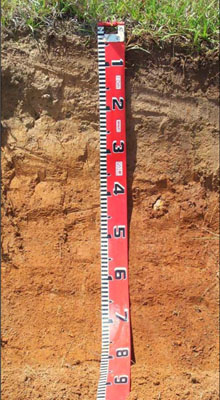 |
| A12 | 5 – 25 cm | Yellowish brown (10YR5/4); fine sandy clay loam; weak polyhedral structure; clear change to: | |
| Subsoil | |||
| B1 | 25 – 45 cm | Strong brown (7.5YR4/6); silty clay; moderate prismatic structure; gradual change to: | |
| B2 | 45 – 75 cm+ | Yellowish red (5YR4/6); silty light to medium clay; moderate prismatic structure. |
Comments:
This soil profile is very similar in appearance to EG203 and is expected to behave similarly.
Soil Profile Described By: David Rees and Grant Boyle, 2000.