Victorian Resources Online (archived)
EGW108
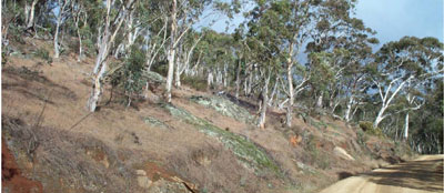
Location: Omeo South
Australian Soil Classification: Eutrophic, Mottled-Subnatric, Brown SODOSOL
Map Unit: Pendergast
Previous Site Name: EG108
General Landscape Description: Undulating low hills
Site Description: Convex lower slope, 2 % slope to North
Land Use: Grazing on annual pasture
Native Vegetation: Montane grassy woodland
Geology: Palaeozoic granite
Insert on side Pendergast C3 profile on right hand side
Soil Profile Morphology:
| Surface soil | 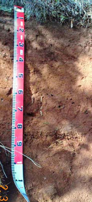 | ||
| A11 | 0 – 20 cm | Dark reddish grey (5YR4/2); sandy loam; moderate polyhedral structure; weak consistence moist; slight (2 – 10%) amounts of fine gravel (2 – 6 mm); gradual change to: | |
| Subsoil | |||
| B1 | 20 – 40 cm | Reddish brown (5YR4/4), sandy clay loam; moderate prismatic structure; firm moderately moist; slight (2 – 10%) amounts of fine gravel (2 – 6 mm); pH 6.3; gradual change to: | |
| B2 | 40 – 70+ cm | Reddish brown (2.5YR4/4); sandy light clay ; moderate prismatic structure; firm moderately moist; moderate (20 – 50%) amounts of fine gravel (2 – 6 mm); pH 6.3. |
Key Profile Features:
- The soil has reddish colours throughout, indicating excellent internal drainage.
Chemical and Physical Analysis:
Horizon | Horizon Depth (cm) | pH (water) | pH (CaCl2) | EC dS/m | Exchangeable Acididty meq/100g | Exchangeable Cations | Coarse Sand (0.2-2.0 mm) % | Fine Sand (0.02-0.2 mm) % | Silt (0.002-0.02 mm) % | Clay (<0.002 mm) % | Field Capacity % w/w | Wilting Point % w/w | |||
Ca | Mg | K | Na | ||||||||||||
meq/100g | |||||||||||||||
B1 | 20-40 | 6.3 | 5.6 | 0.05 | 5.1 | 4.3 | 1.1 | 0.27 | 0.06 | 29 | 34 | 19 | 18 | 24.2 | 7.2 |
B2 | 40-70 | 6.3 | 5.6 | 0.05 | 6.1 | 4.3 | 2.1 | 0.43 | 0.1 | 24 | 28 | 14 | 33 | 25.4 | 10.2 |
Comment
- This soil is amongst the less gravelly soils on this map unit.
Profile Described By: I.P. Little and W.T. Ward, 1977.