Victorian Resources Online (archived)
EGW71
Location: Omeo
Australian Soil Classification: Yellow SODOSOL
Map Unit: Omeo (Component 1)
Previous Site Name: EG71
General Landscape Description: Undulating low hills
Site description: Hill-slope, gradient unspecified
Land Use: Grazing on annual pasture
Native Vegetation: Grassy woodland
Geology: Palaeozoic granite
Soil Profile Morphology:
| Surface soil | 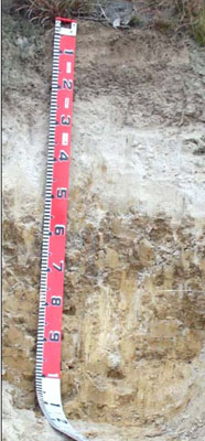 | ||
| A1 | 0 – 25/30 cm | Very dark greyish brown (10YR3/2); sandy loam (light and high in organic matter); weak polyhedral structure; common (10 – 20%) fine (2 – 6 mm) gravel; clear wavy change to: | |
| A2 | 25/30 – 50/55 cm | Very pale brown (10YR7/3) conspicuously bleached (10YR8/2d); loamy sand; massive; strong consistence dry; slight (2 – 10%) fine (2 – 6 mm) gravel; clear wavy change to: | |
| Subsoil | |||
| B21 | 50/55 – 100 cm | Yellowish brown (10YR5/4); medium heavy clay; coarse prismatic structure parting to angular blocky structure; strong consistence dry; slight (2 – 10%) fine (2 – 6 mm) gravel. |
Profile Described By: I.P. Little and W.T. Ward, 1977.