Victorian Resources Online (archived)
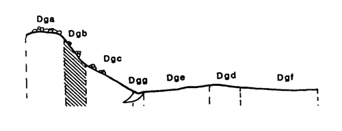
Marong map unit Dgb
Back to: A Land Capability Study of the Rural City of Marong
| Map Unit: | Devonian granodiorite, steep slope | Map Unit Symbol: | Dgb |
| % of Study Area: | 0.2 |
General Description:
The steep slopes in the granodiorite are only a minor component of the Rural City. They are generally rocky and located adjacent to rocky crests on the rolling hills. The soils are very similar to those on the rocky crest; shallow, uniform coarse sands with dark brown sandy loam top soils. Pockets of deeper uniform sands and duplex soils can occur between outcropping tors.
Site characteristics:
| Parent material age: | Devonian | Depth seasonal watertable: | >10 m |
| Lithology: | Granodiorite | Potential recharge to groundwater: | Very High |
| Landform Pattern: | Rolling low hills | Flooding risk: | Nil |
| Element: | Slope | Drainage: | Rapidly drained |
| Slope common: | 33% | Depth to hardrock: | 0.6 m |
| Slope range: | 32 - 35% | ||
| Rock outcrop: | 10 - 20% |
Major vegetation: Long-leaf Box, Yellow Box, Grey Box, Blackwood, Buloke, Black Wattle, Wallaby Grass.
Present land use: Partially cleared, grazing
| Land degradation: | Water erosion | Wind erosion | Salting | Acidification | |
Sheet/rill | Gully | ||||
| Susceptibility | High | Low | Moderate | Low | Low |
| Incidence | Moderate | Very low | Low | Low | Low |
Soil profile characteristics:
| Permeability (measured - average, range): | 20080, 12923 - 29583 mm/day |
| Permeability (estimated): | - |
| Available water capacity: | 96 mm H2O |
| Linear shrinkage (B horizon): | Low (estimate) |
Soil profile description:
| A | 0 - 20 cm | Dark red brown (5YR3/2) sandy loam, apedal, sandy fabric, loose consistence, high organic matter, pH 5.5. Clear transition to |
| C | 20 - 60 cm | Dull red brown (5YR4/4) clayey sand, apedal, sandy fabric, loose consistence, many quartz fragments, pH 5.4. Gradual transition to |
| 60+ cm | Rock |
Soil classification:
| Factual Key (Northcote): | Uc 1.23 (major) Dy 3.11 (minor) |
| Australian Soil Classification: | Arenic, Rudosol; shallow, thin, loamy, non-gravelly |
| Unified Soil Group: | SM |
Interpretation of soil analyses*
Horizon | pH | Gravel % | E.C. (salts) | Nutrient Status | P | K | Al | Organic Matter | Dispersibility |
| A | 5.5** | 21.2 | VL | L | D | S | T | H | L |
| C | 5.4** | 29.0 | VL | VL | D | S | T | L | L |
Land capability assessment
Land Use | Class | Major limiting feature(s)/ landuse |
| Agriculture (CTS values) | C3T5S4 | Steep slope |
| Effluent disposal (septic tanks) | 5 | Steep slope, excessive permeability – risk of polluting groundwater |
| Farm dams (earthen) | 5 | Steep slope, shallow depth to hardrock, very low suitability of subsoil, excessive permeability. |
| Building foundations - slab | 5 | Steep slope |
| Building foundations - stumps/footings | 4 | Steep slope, high risk of slope failure |
| Secondary roads | 5 | Steep slope |
| Urban residential | 5 | Urban residential 5 Secondary roads, building foundations (slab) |
| Rural residential | 5 | Farm dams, effluent disposal, secondary roads, building foundations (slab) |
The high resolution PDF file provided on this page can be viewed using the free Adobe PDF reader, this software can be installed for free from the Adobe website (external link).
A Land Capability Study of the Rural City of Marong - map unit Dgb - (PDF - 37.3 KB)