Victorian Resources Online (archived)
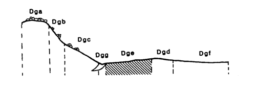
Marong map unit Dge
Back to: A Land Capability Study of the Rural City of Marong
| Map Unit: | Devonian granodiorite, gentle slope | Map Unit Symbol: | Dge |
| % of Study Area: | 4.6 |
General Description:
The gently undulating non-rocky slopes are a major component of the granodiorite land system. The soil types are similar to those found on gentle crests; yellow duplex with brown sandy loam top soils, hardsetting bleached A2 horizons and mottled heavy clay subsoils underlain by a siliceous hardpan. Some minor drainage lines have not been delineated as their soils are not significantly different, only wetter. Outcropping tors occur occasionally and are surrounded by uniform sands.
Site characteristics:
| Parent material age: | Devonian | Depth seasonal watertable: | > 2 m |
| Lithology: | Granodiorite | Potential recharge to groundwater: | Low |
| Landform Pattern: | Undulating low hills | Flooding risk: | Nil |
| Element: | Slope | Drainage: | Well drained |
| Slope common: | 6% | Depth to hardrock: | 1.0 m (variable) |
| Slope range: | 3 - 10% | ||
| Rock outcrop: | <2% |
Major vegetation: Grey Box, Long-leaf Box, Yellow Box, Yellow Gum, Lightwood, Wallaby Grass, Rye Grass, Onion Grass
Present land use: Grazing - mainly sheep (major), residential (minor)
| Land degradation: | Water erosion | Wind erosion | Salting | Acidification | |
Sheet/rill | Gully | ||||
| Susceptibility | Moderate | High | High | Low | Low |
| Incidence | Low | Moderate | Low | Low | Low |
Soil profile characteristics:
| Permeability (measured - average, range): | 7, 3 - 12 mm/day |
| Permeability (estimated): | |
| Available water capacity: | 146 mm H2O |
| Linear shrinkage (B horizon): | 14.2 % |
Soil profile description:
| A1 | 0-9 cm | Greyish yellow brown (10YR4/2) sandy loam, weak structure, angular blocky peds 10-20 mm, rough fabric, very weak consistence, high organic matter, pH 5.0. Clear transition to |
| A21 | 9-23 cm | Dull yellow orange (10YR6/3) sandy loam, bleached (7.5YR8/4) when dry, weak structure, subangular blocky peds 10-20 mm, rough fabric, very weak consistence, pH 5.3. Clear transition to |
| A22 | 23-38 cm | Dull yellow orange (10YR7/3) sandy loam, bleached when dry, apedal, sandy fabric, loose consistence, granitic fragments are common, pH 5.7. Clear transition to |
| B2 | 38-76 cm | Greyish yellow brown (10YR6/2) heavy day, many distinct medium sized red mottles, weak structure, subangular blocky peds 20-50 mm, smooth fabric, very firm consistence, pH 5.6. Clear transition to |
| B3 | 76-100 cm | Greyish brown (7.5Y5/2) light clay, many faint red coarse mottles, moderate structure, angular blocky peds 10-20 mm, smooth fabric, moderately firm consistence, many coarse granitic fragments, pH 5.1 |
| C | 100 cm | Hardpan |
Soil classification:
| Factual Key (Northcote): | Dy 3.41 (major) Dy 2.41 (minor) |
| Australian Soil Classification: | Bleached-Sodic, Mesotrophic, Grey, Chromosol; moderate, thick, loamy, non-gravelly |
| Unified Soil Group: | CH |
Interpretation of soil analyses*
Horizon | pH | Gravel % | E.C. (salts) | Nutrient Status | P | K | Al | Organic Matter | Dispersibility |
| A1 | 5.0** | 3.1 | VH | VL | D | S | H | L | L |
| A21 | 5.3 | 7.3 | M | VL | D | D | L | L | L |
| A22 | 5.7 | 15.1 | H | H | D | D | S | L | L |
| B2 | 5.6** | 6.3 | H | H | D | S | S | VL | H |
| B3 | 5.1 | 14.4 | H | H | D | S | S | VL | H |
Land capability assessment
Land Use | Class | Major limiting feature(s)/ landuse |
| Agriculture (CTS values) | C3T3S4 | Highly susceptible to wind and gully erosion, shallow depth to hardpan, high electrical conductivity in subsoil |
| Effluent disposal (septic tanks) | 5 | Very slow permeability |
| Farm dams (earthen) | 4 | Shallow depth to hardpan, low suitability of subsoil, highly dispersible subsoil |
| Building foundations - slabs | 3 | Gentle slope |
| Building foundations - stumps/footings | 3 | Moderate linear shrinkage |
| Secondary roads | 4 | Highly dispersible subsoil |
| Urban residential | 4 | Secondary roads |
| Rural residential | 5 | Effluent disposal |
The high resolution PDF file provided on this page can be viewed using the free Adobe PDF reader, this software can be installed for free from the Adobe website (external link).
A Land Capability Study of the Rural City of Marong - map unit Dge - (PDF - 38.8 KB)