Victorian Resources Online (archived)
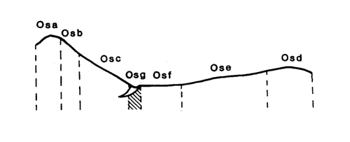
Marong Map unit Osg
Back to: A Land Capability Study of the Rural City of Marong
| Map Unit: | Ordovician sediments, drainage depression | Map Unit Symbol: | Osg |
| % of Study Area: | 3.2 |
General Description:
Drainage lines are numerous throughout the sedimentary hills. Those that are mapped may be slightly exaggerated in width, while very small drainage lines have not been mapped. As with all drainage units, the soils are variable. The dominant soil type is yellow duplex with hardsetting dark brown loam top soils, bleached horizons and mottled, yellowish clay subsoils. Occasionally the texture difference throughout the profile is gradational. In minor drainage lines the clay subsoils can be slightly redder.
Site characteristics:
| Parent material age: | Ordovician | Depth seasonal watertable: | 2 - 5 m |
| Lithology: | Sediments | Potential recharge to groundwater: | Low |
| Landform Pattern: | Rolling hills - undulating low hills | Flooding risk: | High |
| Element: | Drainage depression | Drainage: | Poorly drained |
| Slope common: | 2% | Depth to hardrock: | 1.1 m |
| Slope range: | 1 - 3% | ||
| Rock outcrop: | 0% |
Major vegetation: Grey Box, Red Ironbark, Yellow Box, Golden Wattle, Hedge Wattle, Black-anther Flax-lily, Wallaby Grass
Present land use: Native forest
| Land degradation: | Water erosion | Wind erosion | Salting | Acidification | |
Sheet/rill | Gully | ||||
| Susceptibility | Low | High | Low | Moderate | Moderate |
| Incidence | Low | Moderate | Nil | Moderate | Low |
Soil profile characteristics:
| Permeability (measured - average, range): | 66, 10 - 130 mm/day |
| Permeability (estimated): | - |
| Available water capacity: | 164 mm H2O |
| Linear shrinkage (B horizon): | 8.3 % |
Soil profile description:
| A1 | 0-9 cm | Hardsetting dark brown (7.5YR3/4) fine sandy loam, weak structure, subangular blocky peds 5 -10 mm, rough fabric, very weak consistence, less than 2% angular medium sized sedimentary fragments, pH 5.0. Clear transition to |
| A2 | 9-32 cm | Dull yellowish brown (10YR5/3) fine sandy loam, bleached (10YR7/2) when dry, hardsetting, common faint medium sized yellow and orange mottles, weak structure, subangular blocky peds 10 -20 mm, smooth fabric, moderately weak consistence, less than 2% organic segregations, a few angular medium sized sedimentary fragments, pH 5.4. Clear transition to |
| B21 | 32-54 cm | Greyish yellow brown (10YR6/2) light clay, common medium sized distinct yellowish brown mottles, moderate structure, angular blocky peds 5 -10 mm, smooth fabric, moderately weak consistence, pH 6.1. Clear transition to |
| B22 | 54-80 cm | Greyish yellow brown (10YR5/2) light clay, many medium sized distinct bright yellowish brown mottles, moderate structure, angular blocky peds 5-10 mm, smooth fabric, very firm consistence, less than 2% angular medium sized sedimentary fragments, pH 6.2. Abrupt transition to |
| B23 | 80-111 cm | Bright brown (7.5YR5/6) light sandy clay loam, massive, earthy fabric, moderately firm consistence, many angular medium sized metamorphic gravel fragments, pH 6.8. Clear transition to |
| C | 111 cm | Rock |
Soil classification:
| Factual Key (Northcote): | Dy3.42 (major) Dy3.43, Dr2.43, Gn3.92/3, Gn3.02/3 (minor) |
| Australian Soil Classification: | Bleached - Mottled, Magnesic, Grey, Chromosol; deep, thick, loamy, non-gravelly |
| Unified Soil Group: | CL |
Interpretation of soil analyses*
Horizon | pH | Gravel % | E.C. (salts) | Nutrient Status | P | K | Al | Organic Matter | Dispersibility |
| A1 | 5.0** | 3.0 | VL | D | S | S | S | H | L |
| A2 | 5.4** | 3.0 | VL | D | S | S | S | M | L |
| B21 | 6.1 | 0.7 | VL | D | S | S | S | L | H |
| B22 | 6.2 | 4.3 | VL | D | S | S | S | VL | H |
| B23 | 6.8 | 21.9 | VL | D | S | S | S | VL | M |
Land capability assessment
Land Use | Class | Major limiting feature(s)/ landuse |
| Agriculture (CTS values) | C3T2S4 | Highly susceptible to gully erosion |
| Effluent disposal (septic tanks) | 5 | Poorly drained, high risk of flooding |
| Farm dams (earthen) | 4 | Shallow depth to hardrock, low suitability of subsoil, high dispersible subsoil |
| Building foundations - slab | 5 | Poor drainage, high risk of flooding |
| Building foundations - stumps/footings | 5 | Poor drainage, high risk of flooding |
| Secondary roads | 5 | Poor drainage, high risk of flooding |
| Urban residential | 5 | Secondary roads, building foundations |
| Rural residential | 5 | Effluent disposal, secondary roads, building foundations |
The high resolution PDF file provided on this page can be viewed using the free Adobe PDF reader, this software can be installed for free from the Adobe website (external link).
A Land Capability Study of the Rural City of Marong - map unit Osg - (PDF - 38 KB)