Victorian Resources Online (archived)
Marong map unit Qbr
Back to: A Land Capability Study of the Rural City of Marong
| Map Unit: | Quaternary basalt, very gentle slope, rocky | Map Unit Symbol: | Qbr |
| % of Study Area: | 2.7 |
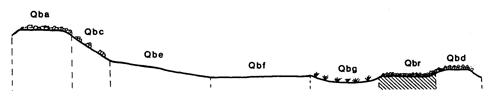
General Description:
These very gentle slopes with greater than 40% rock outcrop occur at random on the basaltic plain. The associated soils are reddish brown clay loam which vary in depth but are commonly very shallow. Red duplex and gradational soils that occur on the non rocky very gentle slopes sometimes occur in deep pockets between the rocks. The rocks are occasionally cleared to allow cultivation.
Site characteristics:
| Parent material age: | Quaternary | Depth seasonal watertable: | > 5 m |
| Lithology: | Basalt | Potential recharge to groundwater: | Very high |
| Landform Pattern: | Lava plain | Flooding risk: | Nil |
| Element: | Slope | Drainage: | Rapidly drained |
| Slope common: | 2 % | Depth to hardrock: | 0.2 m |
| Slope range: | 0-3 % | ||
| Rock outcrop: | 40-50% |
Major vegetation: Yellow Box, Grey Box, Long-leaf Box, Buloke, Lightwood, Kangaroo Grass, Wallaby Grass, Capeweed
Present land use: Grazing - sheep
| Land degradation: | Water erosion | Wind erosion | Salting | Acidification | |
Sheet/rill | Gully | ||||
| Susceptibility | Moderate | Very low | Low | Low | Low |
| Incidence | Low | Nil | Low | Nil | Low |
Soil profile characteristics:
| Permeability (measured - average, range): | 2070, 1161 - 3091 mm/day |
| Permeability (estimated): | - |
| Available water capacity: | 38 mm H2O |
| Linear shrinkage (B horizon): | N.A. (Low - estimated) |
Soil profile description:
| A | 0 -12 cm | Dark reddish brown (5YR3/3) clay loam, weak structure, subangular blocky peds 2-5 mm, smooth fabric, moderately firm consistence, a few coarse basalt fragments, moderate organic matter content, pH 6.0. Clear transition to |
| C | 12 + cm | Rock |
Soil classification:
| Factual Key (Northcote): | Um6.43 (major), Dr2.13 (minor) |
| Australian Soil Classification: | Lithic, Leptic, Rudosol; shallow, medium, clay loamy, non-gravelly |
| Unified Soil Group: | CL |
Interpretation of soil analyses*
Horizon | pH | Gravel % | E.C. (salts) | Nutrient Status | P | K | Al | Organic Matter | Dispersibility |
| A | 6.0 | 6.3 | VL | L | D | S | S | M | L |
Land capability assessment
Land Use | Class | Major limiting feature(s)/ landuse |
| Agriculture (CTS values) | C3T2S5 | Shallow depth to hardrock, very low available water capacity, high gravel/stone/boulder content |
| Effluent disposal (septic tanks) | 5 | Shallow depth to hardrock, very rapid permeability – risk of polluting groundwater |
| Farm dams (earthen) | 5 | Shallow depth to hardrock, very low suitability of subsoil, very rapid permeability |
| Building foundations - slab | 5 | Shallow depth to hardrock |
| Building foundations - stumps/footings | 5 | Shallow depth to hardrock |
| Secondary roads | 5 | Shallow depth to hardrock |
| Urban residential | 5 | Secondary roads, building foundations |
| Rural residential | 5 | Farm dams, effluent disposal, secondary roads, building foundations |
The high resolution PDF file provided on this page can be viewed using the free Adobe PDF reader, this software can be installed for free from the Adobe website (external link).
A Land Capability Study of the Rural City of Marong - map unit Qbr - (PDF - 37.7 KB)