Victorian Resources Online (archived)
Marong map unit Tfe1
Back to: A Land Capability Study of the Rural City of Marong
| Map Unit: | Tertiary fan, gentle slope, 1 | Map Unit Symbol: | Tfe1 |
| % of Study Area: | 0.2 |
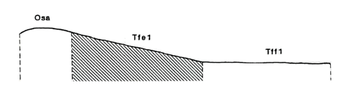
General Description:
These gentle fans were derived from Ordovician sediments and overlie the western margin of the granodiorite. The associated soils are deep red duplex with hardsetting loam top soils and red heavy clay subsoils which become brown and mottled with depth. The soils are well structured and calcium carbonate nodules occur deep in the profile.
Site characteristics:
| Parent material age: | Ordovician | Depth seasonal watertable: | > 2 m |
| Lithology: | Sediments | Potential recharge to groundwater: | Low |
| Landform Pattern: | Undulating rises | Flooding risk: | Nil |
| Element: | Slope | Drainage: | Well drained |
| Slope common: | 8% | Depth to hardrock: | > 1.6 m |
| Slope range: | 3 - 10% | ||
| Rock outcrop: | < 2 m |
Present land use: Grazing (major), cropping, native forest (minor)
| Land degradation: | Water erosion | Wind erosion | Salting | Acidification | |
Sheet/rill | Gully | ||||
| Susceptibility | High | High | Low | Low | Moderate |
| Incidence | Moderate | Low | Low | Low | Low |
Soil profile characteristics:
| Permeability (measured - average, range): | 5, 3-8 mm/day |
| Permeability (estimated): | |
| Available water capacity: | 265 mm H2O |
| Linear shrinkage (B horizon): | 14.6 % |
Soil profile description:
| A1 | 0-15 cm | Dark reddish brown (5YR3/2) hardsetting loam, moderate structure, subangular blocky peds 5-10 mm, smooth fabric, moderately firm consistence, a few fine rounded ferruginous gravel fragments, pH 5.8 Clear transition to |
| B21 | 15-58 cm | Dull reddish brown (5YR4/4) heavy clay, moderate structure, subangular blocky peds 10-20 mm, smooth fabric, moderately firm consistence, less than 2% rounded fine ferruginous gravel fragments, pH 8.0. Gradual transition to |
| B22 | 58-74 cm | Dull reddish brown (5YR4/4) heavy clay, moderate structure, subangular blocky peds 10-20 mm, smooth fabric, moderately firm consistence, less than 2% rounded fine ferruginous gravel fragments, pH 9.0. Clear transition to |
| B23 | 74-121 cm | Dull brown (7.5YR5/4) medium clay, a few medium faint reddish brown mottles, strong structure, angular blocky peds 10-20 mm, smooth fabric, very firm consistence, common moderately calcareous nodules, less than 2% fine rounded ferruginous gravel fragments, pH 9.2. Clear transition to |
| B24 | 121-157+ cm | Dull orange (7.5YR6/4) medium clay, common medium faint reddish brown mottles, strong structure, angular blocky peds 5-10 mm, smooth fabric, very firm consistence, common highly calcareous nodules, a few fine rounded ferruginous gravel fragments, pH 9.6 |
Soil classification:
| Factual Key (Northcote): | Dr 2.13 |
| Australian Soil Classification: | Calcic, Hypernatric, Red, Sodosol; very deep, medium, silty, non-gravelly |
| Unified Soil Group: | CH |
Interpretation of soil analyses*
Horizon | pH | Gravel % | E.C. (salts) | Nutrient Status | P | K | Al | Organic Matter | Dispersibility |
| A1 | 5.8 | 22.7 | VL | L | D | S | T | T | M |
| B21 | 8.0 | 5.6 | M | H | D | S | S | S | VH |
| B22 | 9.0 | 8.3 | H | H | D | S | S | S | L |
| B23 | 9.2 | 14.0 | H | H | D | S | S | S | H |
| B24 | 9.6 | 7.6 | H | H | D | S | S | S | H |
Land capability assessment
Land Use | Class | Major limiting feature(s)/ landuse |
| Agriculture (CTS values) | C3T3S4 | Highly susceptible to sheet/rill and gully erosion, high electrical conductivity in subsoil |
| Effluent disposal (septic tanks) | 5 | Very slow permeability |
| Farm dams (earthen) | 5 | Very dispersible subsoil |
| Building foundations - slab | 3 | Moderate slope |
| Building foundations - stumps/footings | 3 | Moderate linear shrinkage |
| Secondary roads | 5 | Very dispersible subsoil |
| Urban residential | 5 | Secondary roads |
| Rural residential | 5 | Farm dams, effluent disposal, secondary roads |
The high resolution PDF file provided on this page can be viewed using the free Adobe PDF reader, this software can be installed for free from the Adobe website (external link).
A Land Capability Study of the Rural City of Marong - map unit Tfe1 - (PDF - 213 KB)