Victorian Resources Online (archived)
Land Systems
| Back to Bet Bet Creek Catchment Homepage | Land Inventory of the Loddon River Catchment |
The Land Systems method involves an ecological approach - integrating environmental features often mapped singly, eg. rainfall, geology, topography, soils and indigenous vegetation. Patterns occur, governed by climate, geology and landform, which interact over time to influence the distribution of soils and vegetation. A Land System is therefore a complex mapping unit that contains a pattern of land components each of which has little variation in climate, lithology (rock type), landform, soil and indigenous vegetation. The land component can therefore be regarded as a unit of management
for broad-scale uses such as dryland farming or forestry.
Land System surveys have generally resulted in maps at 1:100 000 to 1:250 000 scale being produced. Many of these published studies describe (but do not map) the individual components of each Land System.
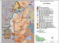 Bet Bet Land Systems | This map shows Land Systems that were mapped by Noel Schoknecht as part of the Land Inventory of the Catchment of the Loddon River Catchment. This study was published by the former Department of Conservation, Forests and Lands in 1988. The map legend can be clicked on to reveal information about each of the Land Systems shown. |