Victorian Resources Online (archived)
LP114a
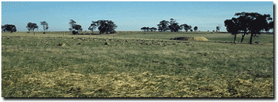
Location: Natte Yallock
Aust. Soil Class.: Hypocalcic, Subnatric, Brown SODOSOL
General Site Description: Undulating plain near small tributary of Bet Bet Creek.
Geology: Basalt (Quaternary)
 Site LP114 Soil Landscape |
Soil Profile Morphology:
| Surface Soil | 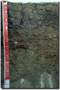 Site LP114 Soil Profile | ||
| A1 | 0-5 cm | Dark yellowish brown (10YR3/4); fine sandy clay loam; moderate fine blocky structure; very firm consistence (dry); pH 5.7; abrupt change to: | |
| Subsoil | |||
| B21 | 5-30 cm | Dark brown (7.5YR4/4); medium heavy clay; moderate coarse blocky structure, parting to moderate medium sized blocky structure; strong consistence (dry); pH 7.3; abrupt change to: | |
| B22 | 30-80 cm | Yellowish brown (10YR5/4); medium heavy clay; strong consistence (moderately moist); few (<2%) hard carbonate nodules; occasional basalt cobbles (up to 200 mm diameter); highly calcareous; pH 9.1; clear change to: | |
| B23 | 80-90 cm | Greyish brown (10YR5/2); medium clay; firm consistence (moderately moist); highly calcareous; pH 9.3; sharp change to: | |
| B24 | 90 + cm | Weathered Basalt . | |
- Strong texture contrast between a shallow surface (A) horizon and the upper subsoil (B21) horizon.
- Contains carbonate nodules within the subsoil.
- Weathered basalt at 90 cm.
pH | Salinity Rating | |||
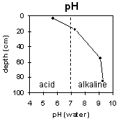
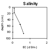
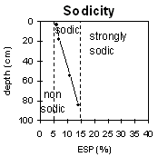
Surface (A1 horizon) | Strongly acid | Very low | Marginally Sodic | None 1 |
Subsoil (B21 horizon) | Slightly alkaline | Low | Sodic | Slight2 |
Deeper subsoil (at 150-200 cm) | Very strongly alkaline | Low | Sodic | None 2 |
 |  |  | 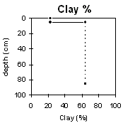 |
Horizon | Horizon Depth | pH (water) | pH CaCl2 | EC dS/m | NaCl % | Exchangeable Cations | Ex Al mg/kg | Ex Ac meq/100g | Field pF2.5 | Wilting Point pF4.2 | Coarse Sand (0.2-2.0mm) | Fine Sand (0.02-0.2mm) | Silt (0.002-0.02mm) | Clay (<0.002mm) | |||
Ca | Mg | K | Na | ||||||||||||||
meq/100g | |||||||||||||||||
A1 | 0-5 | 5 | 4 | 3 | 1 | 0.5 | 31.8 | 11.2 | 5 | 48 | 18 | 23 | |||||
B21 | 5-30 | 7.3 | 6.1 | 0.09 | 14 | 14 | 1.7 | 2 | 51.9 | 28.3 | 2 | 18 | 10 | 64 | |||
B22 | 30-80 | 9.1 | 8.2 | 0.43 | 0.06 | 28 | 20 | 1.3 | 6.1 | 53.6 | 26.5 | ||||||
B23 | 80-90 | 9.3 | 8.4 | 0.64 | 0.05 | 28 | 21 | 1.1 | 8.2 | ||||||||
Whole Profile
- Management strategies for all soils should aim to increase organic matter levels in the surface soil; minimise the degradation of soil aggregates and porosity; promote the development of stable biopores; improve the calcium status of the cation complex (when sodium is a significant part – i.e. sodic) and break up any hardpans. Less frequent tillage, using less aggressive implements, and working the soil at optimum moisture contents can all assist in maintaining soil aggregation and porosity as well as reducing the breakdown of organic matter.
- Plant available water capacity (PAWC) is estimated to be moderate (estimated at 130 mm). This is based on available laboratory data and assumes an effective rooting depth of 90 cm. Values of exchangeable magnesium are greater than 35% throughout the soil profile (up to 44% with depth). Such levels in some soils may induce potassium deficiency (Baker and Eldershaw, 1993).
- The level of the organic carbon indicates that the organic matter of the surface soil is low. Organic matter is important for reducing slaking and enhancing soil aggregation, fertility and water holding capacity. Organic matter levels will build up under pasture but will decline if cultivation takes place. Practices such as residue retention, minimum tillage and including pasture rotations should be utilised if cropping occurs.
- The surface horizons are slightly dispersive after remoulding. This indicates that the surface soil may disperse when worked in a moist condition even though it may not disperse in its natural state. The action of rain impact on the soil surface may also cause dispersion. By maintaining some pasture or stubble cover this may be prevented. Tillage or over-stocking on moist to wet soils should be avoided.
- The problems associated with the subsoil horizons in this profile will also affect the surface as any tillage of the shallow (5 cm) surface soil will probably disturb the subsoil.
- The dense and coarsely structured subsoil is sodic and dispersive (and has a low calcium:magnesium ratio). This will result in restricted root and water movement in the subsoil. Water is likely to build up on the top of the subsoil after heavy rains causing waterlogging of the more porous surface horizons.
References:
Baker, D.E. and Eldershaw, V.J. (1993). Interpreting Soil Analysis for Agricultural Land Use in Queensland. Project Report Series. Queensland, Department of Primary Industries.