Victorian Resources Online (archived)
Site LP62
Back to Bet Bet Creek Catchment Homepage
Group: Lexton Landcare Group
Australian Soil Classification: Bleached-Ferric; Eutrophic (nearly Magnesic), Brown CHROMOSOL
General Landscape Description: Located on the ridge of a gently undulating rise (slope 3%). This site is near the boundary of the volcanic plain and Ordovician sedimentary country (foreground of photo).
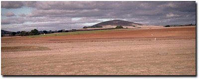 Site LP62 Landscape |
Soil Profile Morphology:
| Surface Soil | 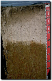 Site LP62 Profile | ||
| A11 | 0-10 cm | Dark brown (7.5YR4/2); fine sandy loam; weakly structured; firm consistence moist; pH 4.8; abrupt change to: | |
| A12 | 10-15 cm | Dark brown (10YR4/3); fine sandy loam; massive; weak consistence moist; pH 5; sharp change to: | |
| A2 | 15-55 cm | Pale brown (10YR6/3) conspicuously bleached (7.5YR7/2d); very fine sandy loam; massive; firm consistence dry; contains many (50%) ferro-manganiferous concretions (2-5 mm size) and very few (<2%) quartz coarse fragments (2 cm size); pH 5.3; sharp change to: | |
| Subsoil | |||
| B21 | 55-85 cm | Yellowish brown (10YR5/4) with yellowish red (5YR4/6) mottles; heavy clay; strong fine prismatic structure; strong consistence dry; pH 5.8; gradual change to: | |
| B22 | 85+ cm | Yellowish brown (10YR5/6) with dark red (2.5YR3/6) and a grey (10YR5/1) mottles; medium clay; strong fine prismatic, parting to strong medium blocky structure (shiny-faced peds); very firm consistence moist; pH 5.6. | |
Key Profile Features:
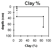
- Very strong texture contrast between surface (A) horizons (9% clay) and subsoil (B21) horizon (85% clay).
- Conspicuously bleached A2 horizon.
pH | Salinity Rating | |||
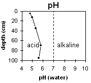
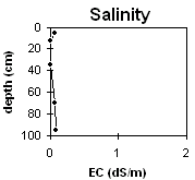
Surface (A1 horizon) | very strongly acid | very low | _ | none1 |
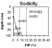
Subsoil (B21 horizon) | moderately acid | very low | non-sodic | none |
Deeper subsoil (at 1 m) | moderately acid | very low | Marginally sodic | none |
 |  |  |  |
Horizon | Horizon Depth | pH (water) | pH CaCl2 | EC dS/m | NaCl % | Exchangeable Cations | Ex Al mg/kg | Ex Ac meq/100g | Field pF2.5 | Wilting Point pF4.2 | Coarse Sand (0.2-2.0mm) | Fine Sand (0.02-0.2mm) | Silt (0.002-0.02mm) | Clay (<0.002mm) | |||
Ca | Mg | K | Na | ||||||||||||||
meq/100g | |||||||||||||||||
A11 | 0-10 | 4.8 | 4 | 0.07 | 0.5 | 0.2 | 0.2 | 0.1 | 81 | 19.1 | 5.1 | 4 | 66 | 20 | 9 | ||
A12 | 10-15 | 5 | 4.1 | 0 | 0.4 | 0.2 | 0.2 | 0 | 59 | 16.7 | 4.3 | ||||||
A2 | 15-55 | 5.3 | 4.4 | 0 | 0.4 | 0.1 | 0.1 | 0.1 | 33 | 18 | 3.8 | 6 | 66 | 23 | 9 | ||
B21 | 58-85 | 5.8 | 5 | 0.07 | 2.4 | 11 | 0.4 | 0.6 | 43 | 31.7 | 1 | 8 | 6 | 85 | |||
B22 | 85+ | 5.6 | 4.7 | 0.08 | 0.9 | 8.3 | 0.2 | 0.8 | |||||||||
Management Considerations:
Whole Profile
- Plant available water capacity (PAWC) is relatively low to moderate (estimated at 105mm). This is based on available laboratory data and assumes an effective rooting depth of 80 cm.
- The very strongly acid surface soil indicates that aluminium and manganese toxicity may occur. The exchangeable aluminium level measured in the laboratory (81 ug/g) is highest at this site. Such levels may affect the growth of aluminium sensitive species such as lucerne, phalaris and medics. Raising the pH level of the surface soil will help reduce the toxicity. A lime test (at the paddock level) may be appropriate to determine how much lime is needed to raise the pH. Deficiencies in molybdenum, calcium magnesium and potassium may also restrict plant growth. Lime can be used to increase soil pH but it should be noted that a pH/aluminium test is best performed from samples taken across the paddock and bulked together. Other factors also need to be considered before lime is recommended (eg. pasture species grown, method of application, local trial responses, soil surface structure and likely cost/benefit).
- The surface soil is hardsetting and has a very high fine sand (66%) and silt (20%) content. When cultivated in a dry condition, these soils will become "powdery" and subsequent rain may form a surface crust. Cultivation of these soils when wet may result in a surface sealing and exacerbation of the hardsetting surface condition on drying. Moderate dispersion occurs after remoulding which indicates that structural degradation will occur if over cultivated in a very moist to wet condition. Maintaining adequate organic matter levels is important to assist in reducing structural degradation (e.g. compaction) on such soils. Practices such as minimum tillage, stubble retention and pasture rotation should be encouraged if cropping occurs.
- The surface soil has a very low inherent fertility (based on the sum of the exchangeable cations). Organic carbon levels are also low. Improving organic matter levels will assist in enhancing soil fertility as well as the water holding capacity of the A1 horizon.
- The deep bleached A2 horizon has a very low nutrient status and is strongly acid. However, exchangeable aluminium values have declined to a level that is not likely to affect most plants.
- The upper subsoil is non-sodic and does not disperse. This indicates that subsoil drainage will not be seriously restricted by sodicity. However, the high proportion of exchangeable magnesium could lead to structural conditions that restrict root and water movement. The presence of a conspicuously bleached subsurface (A2) horizon above the subsoil indicates that periodic waterlogging may occur.
- The calcium:magnesium ratio is very low in the subsoil (<0.2). This indicates that nutrient imbalances may exist (e.g. calcium and potassium deficiency) in the subsoil.