Victorian Resources Online (archived)
Archived content — This page contains material from the Victorian Resources Online (VRO) website. It is no longer maintained and is provided for reference only. This content is hosted by CeRDI and is not endorsed by Agriculture Victoria.
Sitemap
Elevation
|
This Elevation map provides a broadscale overview of the relief across the region. The Digital Elevation Model (DEM) was derived from 1:25 000 topographic data, including contours, spot heights, hydrology (stream enforced) and shore boundaries using ANUDEM software. The interpolation of topographic data is to a 20 m x 20 m grid, which has been resampled to 100 m cell size for display on this website.
| 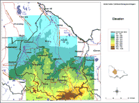
Elevation North Central Region |