Victorian Resources Online (archived)
LP10
| Group: Middle Creek Landcare Group | Australian Soil Classification: Vertic (and Calcic), Subnatric, Grey SODOSOL |
| Northcote Factual Key:Dy 2.13 | Great Soil Group: no suitable group |
| General Landscape Description: Crater floor of volcanic cone at Mt. Duntulm. | |
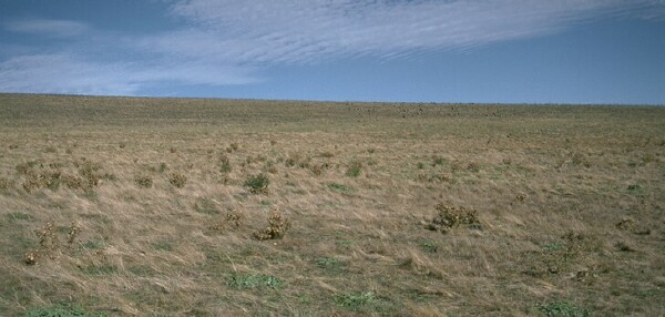 LP10 Landscape |
Soil Profile Morphology
Surface Soil
| A1 | 0-10 cm | Dark greyish brown (10YR3/2); heavy clay loam; moderate coarse blocky structure; strong consistence dry; contains a few (2-10%) vesicular pumice fragments; pH 6.3; sharp and wavy change to: | 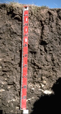 LP10 Profile |
| Subsoil | |||
| B21 | 10-50 cm | Dark greyish brown (10YR4/2); heavy clay; moderate coarse prismatic, breaking down to strong coarse blocky structure; very strong consistence dry; pH 7.4; gradual and wavy change to: | |
| B22k | 50-120 cm | Greyish brown (10YR5/2); heavy clay; strong medium to coarse blocky structure; firm consistence moist; contains a few (2-10%) soft carbonate nodules; pH 9.0; sharp change to: | |
| B23 | 120-180 cm | Light brownish grey (10YR6/2) and brownish yellow (10YR6/6) mottles; heavy clay; strong coarse lenticular, breaking down to finer lenticular structure; contains a few (2-10%) carbonate nodules and soft carbonate;0pH 8.8; sharp change to: | |
| B3 | 180+ cm | Very dark grey (10YR3/1); medium heavy clay; strong lenticular structure (with smooth faced peds); pH 8.7. | |
Key Profile Features
- Strong textural contrast between surface A horizon (31% clay) and subsoil B horizon (57% clay).
- Sodic subsoil.
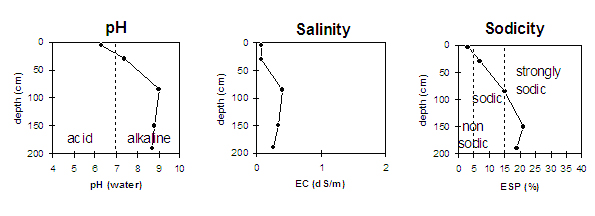
Key Profile Characteristics
pH | Salinity Rating | |||
Surface (A1 horizon) | slightly acid | very low | non-sodic | water-stable1 |
Subsoil (B21 horizon) | slightly alkaline | very low | sodic | slight-moderate |
Deeper subsoil (at 1 m) | strongly alkaline | low | strongly sodic | _ |
| 1 Slight to moderate dispersion occurs after remoulding. | ||||
 |
Horizon | Horizon Depth | pH (water) | pH CaCl2 | EC 1:5 | NaCl | Exchangeable Cations | |||
Ca | Mg | K | Na | ||||||
meq/100g | |||||||||
A1 | 0-10 | 6.3 | 5.4 | 0.08 | 7.6 | 4.2 | 1.2 | 0.3 | |
B21 | 10-50 | 7.4 | 6.2 | 0.08 | 13 | 11.8 | 1.5 | 2 | |
B22k | 50-120 | 9 | 8.2 | 0.4 | <0.05 | 15 | 21.4 | 1.3 | 6.6 |
B23 | 120-180 | 8.8 | 8.1 | 0.34 | <0.05 | 13.5 | 24 | 1.4 | 10.1 |
B3 | 180+ | 8.7 | 7.8 | 0.26 | <0.05 | 10.6 | 17.8 | 1 | 6.8 |
Horizon | Horizon Depth | Ex Al mg/kg | Ex Ac meq/100g | Field pF2.5 | Wilting Point pF4.2 | Coarse Sand (0.2-2.0mm) | Fine Sand (0.02-0.2mm) | Silt (0.002-0.02mm) | Clay (<0.002mm) |
A1 | 0-10 | 32.1 | 19.1 | 7 | 30 | 28 | 31 | ||
B21 | 10-50 | 44.3 | 32.7 | 4 | 18 | 19 | 57 | ||
B22k | 50-120 | ||||||||
B23 | 120-180 | ||||||||
B3 | 180+ |
Management Considerations:
Surface (A) Horizon
- The surface horizon has a moderate overall nutrient status. Organic carbon and total nitrogen levels are reasonable.
- Although non-sodic, the subsoil may disperse when cultivated or overstocked in a moist to wet condition (as is evidenced by moderate dispersion occurring after remoulding). This could lead to some structural degradation (eg. surface sealing) occurring.
Subsoil (B) Horizons
- The coarsely structured subsoil is sodic (becoming strongly sodic with increasing depth) which will restrict root and water movement throughout. The presence of rusty root channel mottling in the surface horizon suggests that water movement is restricted.
- The deeper subsoil (from 50 cm) becomes strongly alkaline which may limit the availability of certain plant nutrients (e.g. phosphorous, iron, manganese and zinc).
- The deep subsoil is vertic (i.e. exhibits a significant degree of shrinking and swelling on wetting and drying) which would have implications for building foundations etc.
Profile described b:y John Martin and Mark Imhof (21/4/94)