Victorian Resources Online (archived)
LP12
| Group: Middle Creek Landcare Group | Australian Soil Classification: Endocalcareous, Epipedal, Black VERTOSOL |
| Northcote Factual Key: Ug 5.12 | Great Soil Group: black earth |
| General Landscape Description: Midslope of the eastern bank of Middle Creek. This soil has developed on alluvium derived from basalt. This alluvium overlies a number of basalt layers. A thin soil horizon (at 130-135cm depth) has developed between two separate flows. | |
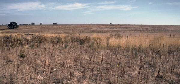 Lp12 Landscape |
Soil Profile Morphology
Surface Soil
| A1 | 0-10 cm | Dark greyish brown (10YR4/2); medium heavy clay; surface cracking; strong coarse blocky structure; strong consistence dry; contains a few (5%) quartz gravels; pH 6.5; sharp and smooth change to: | 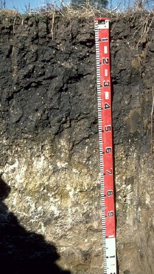 Lp12 Profile |
| Subsoil | |||
| B21 | 10-55 cm | Very dark grey (10YR3/1); heavy clay; strong very coarse blocky, parting to strong medium to coarse blocky structure; very strong consistence dry; many (15-20%) rounded quartz fragments; pH 7.8: | |
| B3k | 55-90 cm | Light brownish grey (2.5Y6/2); heavy clay; moderate coarse prismatic, parting to strong coarse blocky structure; very strong consistence dry; contains many (>20%) amount soft carbonates and some dark (manganese) segregations as well as many quartz fragments; pH 9.0; irregular and sharp change to: | |
| C | 90-130 cm | Weathered and non-weathered olivine basalt: | |
| 2B2 | 130-135 cm | Light brownish grey (2.5Y6/2); heavy clay; strong coarse polyhedral structure; very strong consistence dry | |
| 2C | 135+ cm | Weathered olivine basalt. | |
Key Profile Features
- Clay texture throughout profile.
- Surface cracking.
Key Profile Characteristics
pH | Salinity Rating | |||
Surface (A1 horizon) | slightly acid | very low | non-sodic | none |
Subsoil (B21 horizon) | slightly alkaline | very low | non-sodic | none |
Deeper subsoil (at 75 cm) | strongly alkaline | very low | sodic | _ |
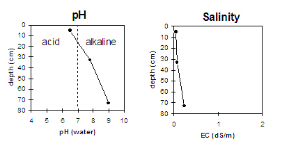 |
Horizon | Horizon Depth | pH (water) | pH CaCl2 | EC 1:5 | NaCl | Exchangeable Cations | |||
Ca | Mg | K | Na | ||||||
meq/100g | |||||||||
A1 | 0-10 | 6.5 | 5.4 | 0.05 | 13.8 | 7.2 | 0.8 | 0.2 | |
B21 | 10-55 | 7.8 | 6.7 | 0.07 | 20.4 | 14.6 | 0.8 | 1.4 | |
B3k | 55-90 | 9 | 8.1 | 0.24 | 13.5 | 16.8 | 0.6 | 1.5 | |
Horizon | Horizon Depth | Ex Al mg/kg | Ex Ac meq/100g | Field pF2.5 | Wilting Point pF4.2 | Coarse Sand (0.2-2.0mm) | Fine Sand (0.02-0.2mm) | Silt (0.002-0.02mm) | Clay (<0.002mm) |
A1 | 0-10 | 32.8 | 21.2 | 7 | 29 | 18 | 43 | ||
B21 | 10-55 | 43.5 | 30.2 | ||||||
B3k | 55-90 |
Management Considerations:
Surface (A) horizon
- Moderate gravel content near surface may interfere with cultivation.
- The clay surface horizon has a high overall nutrient status. Organic carbon and total nitrogen levels are reasonable.
- The surface will be slowly permeable.
- The relatively high wilting point (21%) indicates that plants will not be able to fully utilise light rains falling on relatively dry soils as there will be insufficient moisture to wet the soil above the wilting point. This may result in moisture stress to plants in a dry spring.
- Excessive cultivation, trafficking or overstocking of cracking clay soils when moist to wet, can result in compaction below the soil surface and result in structural decline. Such soils are best cultivated when they are dry (ie. drier than the plastic limit) throughout the cultivation depth.
Subsoil (B) horizons
- The subsoil has a very high overall nutrient status.
- The upper subsoil is non-sodic but is coarsely structured which will restrict movement of finer roots down the profile.
- The deeper subsoil (from 55 cm depth) is strongly alkaline which may limit the availability of certain plant nutrients (eg. phosphorous, iron, manganese and zinc). The deeper subsoil is also sodic which may result in restricted root and water movement below 55 cm depth.
Notes
- Profile described by John Martin and Mark Imhof (22/4/94)