Victorian Resources Online (archived)
LP13
| Group: Middle Creek Landcare Group | Australian Soil Classification: Vertic (and Hypocalcic), Subnatric, Black SODOSOL; intermixed with Yellow SODOSOL |
| Northcote Factual Key:Dd 2.13 and Dy 3.43 | Great Soil Group: solodic |
| General Landscape Description: Midslope of a rise on a gently undulating volcanic plain. In its original state it is likely that this country displayed gilgai microrelief (ie. "crabholey country") which has since been levelled out by cultivation. | |
Soil Profile Morphology
Surface Soil
| A1 | 0-15 cm | Dark yellowish brown (10YR4/4); fine sandy clay loam; hardsetting surface condition; weakly structured; very firm consistence dry; contains very few (2%) iron nodules and some rusty root channel mottling; pH 5.4; sharp and smooth change to: | 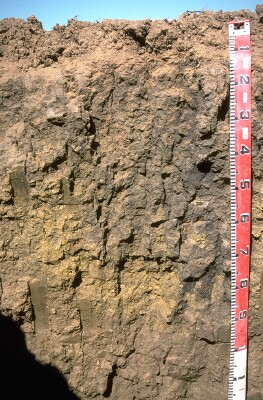 LP13 Profile |
| Subsoil | |||
| B2 | 15-70 cm | Very dark greyish brown (10YR3/2) with faint brownish yellow (10YR6/8) mottles; heavy clay; moderate coarse prismatic structure (with smooth faced peds); strong consistence moist; contains a few (2-10%) dark (manganese) nodules; pH 8.0; irregular change to: | |
| B31 | 70-90 cm | Olive grey (5Y5/2) with brownish yellow (10YR6/8) mottles; heavy clay; moderate coarse prismatic, parting to strong coarse blocky structure; very strong consistence dry; contains a slight (2-10%) amount of fine iron nodules; pH 8.6; irregular change to: | |
| B32 | 90+ cm | Dark yellowish brown (10YR4/4) with yellowish brown (10YR5/6) diffusely mottles; heavy clay; strong coarse prismatic structure; very strong consistence moist; contains a few (2-10%) hard carbonates as well as iron nodules; pH 8.9. | |
| Note: An irregular and discontinuous bleached A2 depression (similar to SITE 11) occurs at this site. | |||
Key Profile Features
- Strong texture contrast between surface and subsoil horizons.
- Sodic subsoil.
- Discontinuous bleached A2 horizon.
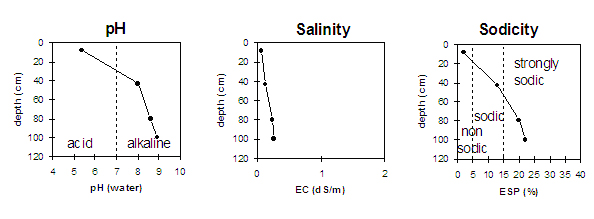
Key Profile Characteristics
pH | Salinity Rating | |||
Surface (A1 horizon) | strongly acid | very low | non-sodic | none |
Subsoil (B2 horizon) | moderately alkaline | very low | sodic | strong |
Deeper subsoil (at 1 m) | strongly alkaline | very low | strongly sodic | moderate |
 |
Horizon | Horizon Depth | pH (water) | pH CaCl2 | EC 1:5 | NaCl | Exchangeable Cations | |||
Ca | Mg | K | Na | ||||||
meq/100g | |||||||||
A1 | 0-15 | 5.4 | 4.6 | 0.06 | 4.6 | 1.5 | 1.1 | 0.1 | |
B2 | 15-70 | 8 | 6.8 | 0.13 | 8.8 | 11.2 | 0.8 | 3.1 | |
B31 | 70-90 | 8.6 | 7.5 | 0.24 | 10 | 13.6 | 0.7 | 6+.2 | |
B32 | 90+ | 8.9 | 7.9 | 0.26 | 8.7 | 13.1 | 6.4 | ||
Horizon | Horizon Depth | Ex Al mg/kg | Ex Ac meq/100g | Field pF2.5 | Wilting Point pF4.2 | Coarse Sand (0.2-2.0mm) | Fine Sand (0.02-0.2mm) | Silt (0.002-0.02mm) | Clay (<0.002mm) |
A1 | 0-15 | 32 | 29.3 | 14.1 | |||||
B2 | 15-70 | 38.5 | 25.3 | ||||||
B31 | 70-90 | ||||||||
B32 | 90+ |
Management Considerations:
Surface (A) horizon
- Aluminium toxicity can occur in strongly acid surface soils. The exchangeable aluminium value measured in the laboratory was not as high as for SITE 11 but could potentially affect the growth of highly sensitive species (eg. lucerne and phosphorus). However, exchangeable manganese was relatively high and may affect some species. A lime test (sampled at the paddock level) may be appropriate to determine whether lime is needed to raise pH levels.
- Overall nutrient status of the surface soil is low, but levels of organic carbon and total nitrogen are reasonable.
- The water holding capacity of the surface horizon is relatively high. However, plant available water capacity is limited by the shallow A horizon above the sodic subsoil.
- As with SITE 11, the depth to the subsoil will vary across the paddock. This could result in variations in crop yield.
Subsoil (B) Horizons
- Water and root movement is likely to be restricted by the sodic subsoil (which disperses strongly). The deleterious effect of sodium on the soils structure is likely to be reinforced by the high levels of exchangeable magnesium in relation to calcium (Ca:Mg 0.78) in the B21 horizon. The irregular occurrence of a bleached A2 horizon and presence of rusty root channel mottling in the surface soil indicates that waterlogging problems occur and that, like the site at Fred Seers (SITE 11), this area originally displayed gilgai microrelief (ie. "crabholey") which has since been levelled out by cultivation.
- At depth the subsoil horizon becomes strongly alkaline which may limit availability of certain plant nutrients (eg. phosphorous, iron, manganese and zinc).
Notes
- Profile described by Mark Imhof (22/4/94)