Victorian Resources Online (archived)
LP38
| Property: State Forest | Australian Soil Classification: Acidic-Sodic, Eutrophic (nearly Magnesic), Red DERMOSOL |
| Northcote Factual Key: Um 2.21 | Geology: Cambrian marine sediments (shale, quartz). |
| General Landscape Description: Upper slope of hillslope in State Forest. Vegetation includes Ironbark (Eucalyptus sideroxylon), Grey Box (E. microcarpa) and Golden Wattle (Acacia pycnantha). This site is located approximately 3 km south-west of St Arnaud. | |
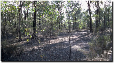 Site LP38 Landscape |
Soil Profile Morphology
Surface Soil
| A1 | 0-5 cm | Brown (7.5YR4/4); sandy clay loam; weakly structured; hardsetting surface condition; firm consistence dry; contains many (25%) siltstone fragments and a few (5%) quartz fragments; pH 5.1; clear change to: | 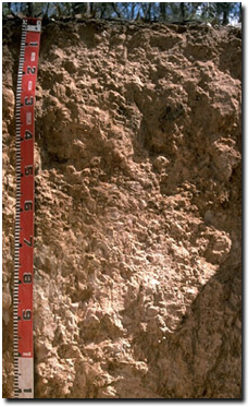 Site LP38 Profile |
| A2 | 5-25 cm | Yellowish red (5YR5/6) conspicuously bleached; light fine sandy clay loam; structureless; strong consistence dry; contains a common (15%) amount of siltstone and few (10%) quartz gravels; strong consistence dry; pH 4.9; clear and wavy change to: | |
| Subsoil | |||
| B21 | 25-45 cm | Yellowish red (5YR5/6); fine sandy clay loam; weak medium blocky structure; very strong consistence dry; contains few (10%) siltstone and very few (1%) quartz fragments; pH 5.3; wavy change to: | |
| B22 | 45-55 cm | Yellowish red (5YR5/6); fine sandy clay loam; moderate medium blocky structure; strong consistence dry; pH 6.0; wavy change to: | |
| C | 55 cm + | Weathering siltstone material; contains a 1 cm thick layer of yellowish red clay at 65 cm depth. | |
Key Profile Features
- Lack of strong texture contrast between surface (A) horizons and subsoil (B) horizons.
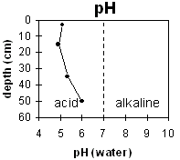
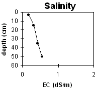
pH | Salinity Rating | |||
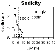
Surface (A1 horizon) | strongly acid | very low | non-sodic | none |
Subsoil (25-45 horizon) | strongly acid | low-medium | non-sodic | moderate |
Deeper subsoil (45-55 cm) | moderately acid | medium | sodic | strong |
 |  |  | |
Horizon | Horizon Depth | pH (water) | pH CaCl2 | EC 1:5 | NaCl | Exchangeable Cations | |||
Ca | Mg | K | Na | ||||||
Meq/100g | |||||||||
A1 | 0-5 | 5.1 | 4.3 | 0.17 | 1.1 | 1.4 | 0.7 | 0.3 | |
A2 | 5-25 | 4.9 | 4.3 | 0.31 | 0.3 | 1.9 | 0.4 | 0.2 | |
B21 | 25-45 | 5.3 | 4.7 | 0.43 | 1 | 3.4 | 0.3 | 0.4 | |
B22 | 45-55 | 6 | 5.4 | 0.55 | 0.1 | 3.7 | 0.3 | 0.7 | |
C | 55 | ||||||||
Horizon | Horizon Depth | Ex Al mg/kg | Ex Ac meq/100g | Field pF2.5 | Wilting Point pF4.2 | Coarse Sand (0.2-2.0mm) | Fine Sand (0.02-0.2mm) | Silt (0.002-0.02mm) | Clay (<0.002mm) |
A1 | 0-5 | 66 | 15.8 | 27.1 | 11.5 | ||||
A2 | 5-25 | 51 | 7.6 | 22.5 | 10.2 | ||||
B21 | 25-45 | 11 | 5.8 | 26.6 | 11.9 | 3.1 | 32 | 43 | 23 |
B22 | 45-55 | 3.3 | 34.6 | 37.5 | 24.5 | ||||
C | 55 |
Management Considerations:
Surface (A) Horizons
- The surface soil is strongly acid. Aluminium becomes more soluble in soils at low pH levels. The level of exchangeable aluminium measured in the laboratory for this pit site I s reasonably high (i.e. > 50 ug/g) may restrict the growth of highly aluminium sensitive species.
- Deficiencies in the trace element molybdenum (Mo) are likely to occur in strongly acid soil. Soil adsorption of Mo increases as pH decreases, leading to reduced availability to plants. Deficiencies in other nutrients (e.g. potassium, phosphorus and calcium) may also occur.
- The surface horizons have a very low inherent fertility (based on the sum of the basic exchangeable cations).
- The subsoil also has a low inherent fertility (based on the sum of the exchangeable basic cations).
- The subsoil has a high percentage of exchangeable magnesium in relation to other cations. Nutrient imbalances may occur as a result (e.g. calcium deficiency).
- Profile described by Mark Imhof, Paul Rampant and Karen De Plater (21/3/95).