Victorian Resources Online (archived)
LP39
| Mapsheet: ST. ARNAUD | Aust. Soil Class.: Acidic, Mesotrophic, Red DERMOSOL (shallow profile) |
| Northcote Factual Key: Um 2.21 | Geology: Metamorphosed Cambrian-Ordovician marine sediments (schist). |
| General Landscape Description: Upper slope of a rounded hill near Carapooee. Original vegetation included Red Stringybark (Eucalyptus macrorhyncha), Grey Box (E. microcarpa) and Spreading Wattle (Acacia genistofolia). | |
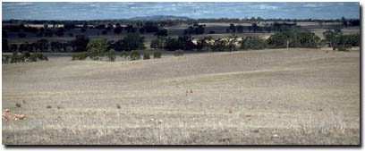 Soil Site LP 39 Landscape |
Soil Profile Morphology
Surface Soil
| A1 | 0-10 cm | Dark reddish brown (5YR3/3); fine sandy loam; hardsetting surface condition; moderate coarse granular structure; firm consistence dry; contains a few (10%) shale fragments and very few (1%) quartz fragments; pH 5.7; clear and wavy change to: | 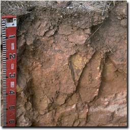 Soil Site LP39 Profile |
| Subsoil | |||
| B21 | 10-30 cm | Red (2.5YR5/8); fine sandy clay loam; weak coarse blocky structure; strong consistence dry; contains a few (10%) shale fragments (3-5 mm size); pH 5.3; clear and wavy change to: | |
| B22 | 30-40 cm | Reddish yellow (5YR6/8); fine sandy clay loam; moderate medium blocky structure; very firm consistence dry; pH 5.0; wavy change to: | |
| C | 40 cm + | Weathered rock. | |
Key Profile Features
- Lack of strong texture contrast between surface (A) and subsoil (B) horizons.
- Shallow soil profile depth.
pH | Salinity Rating | |||
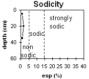
Surface (A1 horizon) | moderately acid | very low | non-sodic | none |
Subsoil (10 - 30 cm) | strongly acid | very low | non-sodic | slight1 |
Deeper subsoil (30 - 40 cm) | strongly acid | very low | non-sodic | none |
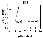 | 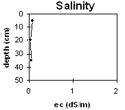 |  | |
Horizon | Horizon Depth | pH (water) | pH CaCl2 | EC 1:5 | NaCl | Exchangeable Cations | |||
Ca | Mg | K | Na | ||||||
Meq/100g | |||||||||
A1 | 0-10 | 5.7 | 4.7 | 0.08 | 2.4 | 1.3 | 0.4 | 0.1 | |
B21 | 10-430 | 5.3 | 4.4 | <0.05 | 0.6 | 0.7 | 0.2 | 0.1 | |
B22 | 30-40 | 5 | 4.2 | 0.05 | 0.4 | 0.7 | 0.2 | 0.1 | |
C | 40 | ||||||||
Horizon | Horizon Depth | Ex Al mg/kg | Ex Ac meq/100g | Field pF2.5 | Wilting Point pF4.2 | Coarse Sand (0.2-2.0mm) | Fine Sand (0.02-0.2mm) | Silt (0.002-0.02mm) | Clay (<0.002mm) |
A1 | 0-10 | 26.5 | 11.7 | ||||||
B21 | 10-430 | 38 | 3.8 | 24.2 | 14.2 | 7.7 | 46.7 | 23.5 | 23 |
B22 | 30-40 | 96 | 6 | 25.4 | 14.2 | ||||
C | 40 |
Whole Profile
- Plant available water capacity (PAWC) will be low due to the shallow effective rooting depth. Plants are likely to suffer moisture stress during dry periods.
- The surface soil has a low inherent fertility (based on the sum of the exchangeable basic cations).
- The surface soil is relatively shallow and should be protected from sheet erosion by maintaining adequate surface cover. Organic carbon levels are reasonable at this site. Organic matter is important for enhancing soil fertility, water holding capacity and aggregate stability.
- The surface soil is moderately acid which indicates that aluminium toxicity should not be a problem. Ideally, however, a pH/aluminium test is best performed on a bulked sample taken from across the paddock. Lime may have been used on this paddock.
- The subsoil is strongly acid. As a result exchangeable aluminium levels are reasonably high – which may affect sensitive species (e.g. lucerne, phalaris).
- The inherent fertility of the subsoil is very low (based on the sum of the exchangeable basic cations).
- Profile described by Mark Imhof, Paul Rampant and Karen De Plater (21/3/95)