Victorian Resources Online (archived)
LP40
| Mapsheet: ST. ARNAUD | Aust. Soil Geology: Tertiary (Miocene) period river gravel deposits.Class.: Ferric, Eutrophic, Red CHROMOSOL |
| Northcote Factual Key: Dr 2.22 | Geology: Tertiary (Miocene) period river gravel deposits. |
| General Landscape Description: Midslope of rise. Original vegetation included Grey Box (Eucalyptus microcarpa). This site is located approximately 4 km east of Kooreh. | |
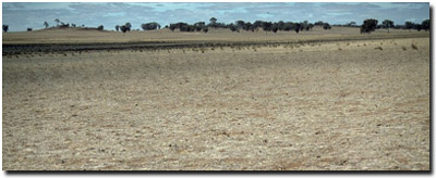 Soil Site LP 40 Landscape |
Soil Profile Morphology
Surface Soil
| A11 | 0-10 cm | Dark reddish brown (5YR3/4); heavy sandy loam; hardsetting surface condition when dry; weak medium blocky structure; firm consistence dry; ironstone nodules common (15%) with a few (5%) quartz fragments; pH 5.5; clear and wavy change to: | 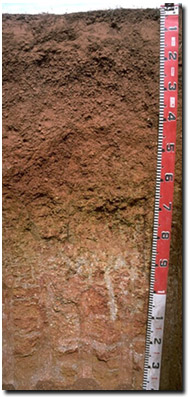 Soil Site LP40 Profile |
| A12 | 10-40 cm | Dark red (2.5YR3/6); clayey (coarse) sand; firm to very firm consistence dry; contains very many (60%) quartz fragments and ironstone nodules are common (20%); pH 6.2; clear and wavy change to: | |
| Subsoil | |||
| B21 | 40-55 cm | Dark red (2.5YR4/8); medium clay; strong fine-medium polyhedral structure; strong consistence dry; contains few (5%) quartz fragments and few (5%) ferruginous nodules; pH 7.0; clear change to: | |
| B22 | 55-80 cm | Brownish yellow (10YR6/8) with red (2.5YR4/8) mottles; medium clay; strong medium polyhedral structure; very firm consistence dry; pH 7.3; clear change to: | |
| C | 80 cm + | Rounded quartz gravels (variably cemented). | |
Key Profile Features
- Strong texture contrast between surface (A) horizons and subsoil (B21) horizons.
- High ironstone gravel content in surface horizons. These are likely to be residual deposits from Tertiary period lateritization.
pH | Salinity Rating | |||
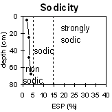
Surface (A1 horizon) | strongly acid | very low | non-sodic | none |
Subsoil (40 - 55 cm) | neutral | very low | non-sodic | none |
Deeper subsoil (55 - 80 cm) | slightly alkaline | very low | non-sodic | none |
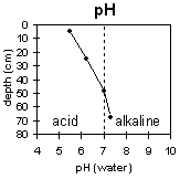 | 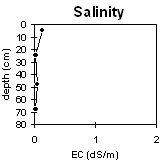 |  | |
Horizon | Horizon Depth | pH (water) | pH CaCl2 | EC 1:5 | NaCl | Exchangeable Cations | |||
Ca | Mg | K | Na | ||||||
Meq/100g | |||||||||
A11 | 0-10 | 5.5 | 4.8 | 0.12 | 3.5 | 0.9 | 1 | <0.1 | |
A12 | 10-40 | 6.2 | 5.2 | <0.05 | 2.9 | 1 | 0.5 | 0.1 | |
B21 | 40-5 | 7 | 6.1 | 0.05 | 6.2 | 3.3 | 0.4 | 0.3 | |
B22 | 55-80 | 7.3 | 6.3 | <0.05 | 6.3 | 4.5 | 0.2 | 0.4 | |
Horizon | Horizon Depth | Ex Al mg/kg | Ex Ac meq/100g | Field pF2.5 | Wilting Point pF4.2 | Coarse Sand (0.2-2.0mm) | Fine Sand (0.02-0.2mm) | Silt (0.002-0.02mm) | Clay (<0.002mm) |
A11 | 0-10 | 15 | 7.9 | ||||||
A12 | 10-40 | 10.3 | 6.3 | ||||||
B21 | 40-5 | 25.7 | 19.3 | ||||||
B22 | 55-80 |
Management Considerations:
Surface (A) Horizons
- Organic matter is important for maintaining surface soil aggregations and preventing slaking. Organic matter levels will build up under pasture but will decline if cultivation takes place. Practices such as residue retention, minimum tillage and including pasture rotations should be utilised if cropping occurs.
- Quartz and ironstone gravel content in surface horizons reduce water availability to shallow rooted species. It may also affect root growth of crop or pasture species with tap roots.
- The surface horizon is strongly acid. This may cause some nutrient deficiencies. A soil pH/aluminium test sampled from across the paddock may, however, be more appropriate to determine if lime is needed to raise soil pH. Other factors need to be considered though before lime is recommended (e.g. type of pasture species grown, method of application, local trial responses, soil surface structure and likely cost/benefit).
- The soil below 10 cm depth becomes only slightly acid which is a good result.
- The subsoil is well structured and non-sodic (and has a calcium:magnesium ratio >1). It should be relatively well draining and provide limited restrictions to root growth. Deeper root growth is likely to be restricted by the compacted gravel layer at 80 cm depth.
- No waterlogging at this site.
- Patches of heavier black clay soil occur in the lower parts of the property.
Profile described by Mark Imhof, Paul Rampant and Karen De Plater (22/3/95).