Victorian Resources Online (archived)
LP41
| Mapsheet: ST. ARNAUD | Aust. Soil Class.: Eutrophic, Hypernatric, Red SODOSOL |
| Northcote Factual Key: Dy 2.42 | Great Soil Group: no suitable group |
| General Landscape Description: Lower midslope of north-south ridge near Fenton's Creek. Original vegetation included Grey Box (Eucalyptus microcarpa), Yellow Gum (E. leucoxylon) and Gold Dust Wattle (Acacia acinacea). | |
| Geology: Lower Ordovician sediments (sandstone and mudstone). | |
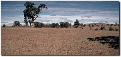 Soil Site LP 41 Landscape |
Soil Profile Morphology
Surface Soil
| A1 | 0-10 cm | Dark brown (7.5YR3/4); fine sandy loam; hardsetting surface condition when dry; weak medium granular structure; very firm consistence dry; pH 5.4; clear change to: | 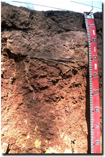 Soil Site LP41 Profile |
| A12 | 10-20 cm | Reddish brown (5YR4/4) conspicuously bleached; fine sandy clay loam; weakly structured; strong consistence dry; contains a few (5%) quartz fragments (5-10 mm size) in pockets; pH 6.3; sharp change to: | |
| Subsoil | |||
| B21 | 20-70 cm | Yellowish red (5YR5/8) medium heavy clay; strong coarse blocky, parting to moderate fine-medium blocky structure; very strong consistence dry; pH 7.3; wavy change to: | |
| C | 70 cm + | Weathered rock. | |
Key Profile Features
- Strong texture contrast between surface (A) horizons and subsoil (B) horizons.
pH | Salinity Rating | |||
Surface (A1 horizon) | strongly acid | low | non-sodic | none |
Subsurface (10 - 20 cm) | slightly acid | very low | non-sodic | none1 |
Subsoil (20 - 70 cm) | slightly alkaline | medium-high | strongly sodic | complete |
 |  |  | |
Horizon | Horizon Depth | pH (water) | pH CaCl2 | EC 1:5 | NaCl | Exchangeable Cations | |||
Ca | Mg | K | Na | ||||||
Meq/100g | |||||||||
A1 | 0-10 | 5.4 | 4.6 | 0.19 | 2.7 | 2 | 0.5 | 0.2 | |
A2 | 10-20 | 6.3 | 5.1 | 0.09 | 1 | 1.8 | 0.3 | 0.3 | |
B21 | 20-70 | 7.3 | 6.5 | 0.68 | 1.6 | 7.1 | 0.9 | 3.5 | |
C | 70 | ||||||||
Horizon | Horizon Depth | Ex Al mg/kg | Ex Ac meq/100g | Field pF2.5 | Wilting Point pF4.2 | Coarse Sand (0.2-2.0mm) | Fine Sand (0.02-0.2mm) | Silt (0.002-0.02mm) | Clay (<0.002mm) |
A1 | 0-10 | 12 | 10.4 | 19.2 | 9.2 | ||||
A2 | 10-20 | 13.7 | 4.3 | ||||||
B21 | 20-70 | 27.8 | 16.8 | ||||||
C | 70 |
Management Considerations:
Surface (A) Horizons
- The surface soil is strongly acid which may restrict the growth of some plants. A pH/aluminium test carried out on sample collected across the paddock could be carried out to determine if lime is needed to raise soil pH. Other factors need to be considered, however, before lime is recommended (e.g. species grown, method of application, local trial responses, likely cost-benefit).
- Maintaining surface cover is important on sloping land in order to restrict loss of surface soil by sheet erosion. It is also important to build up organic matter levels in the surface soil so as to improve soil fertility, aggregate stability and water holding capacity.
- Molybdenum (Mo) deficiency can occur in strongly acid surface soils. Lime applications will make molybdenum more available to plants. Molybdenum is normally applied with Mo enriched superphosphate.
- The bleached subsurface (A2) horizon indicates that periodic waterlogging occurs on top of the slowly permeable subsoil. This horizon is likely to become 'spewy' as a result.
- Exchangeable magnesium is high in the surface horizons. This may result in some nutrient imbalances (e.g. potassium deficiency).
- The conspicuously bleached subsurface (A2) horizon indicates that periodic waterlogging occurs on top of the poorly permeable subsoil after heavy rains. Lateral movement of water downslope along top of reasonably impermeable subsoil.
- The subsurface (A2) horizon disperses strongly after remoulding. It could potentially develop into a hardpan if cultivated in a moist to wet condition.
- The subsoil is strongly sodic and dispersive (and has a low calcium:magnesium ratio) which will result in restricted root and water movement in the subsoil. Water is likely to build up on the top of the subsoil after heavy rains causing waterlogging of the subsurface horizon.
- The high level of exchangeable sodium in the subsoil may also result in nutrient imbalances and may even have a toxic effect on some plants.
- The dispersive subsoil will be highly erodible if surface soil is removed. Maintaining a protective cover of surface soil and vegetation is important, especially on sloping land. Also, sodic soils present constraints for dam construction which need to be managed.
- The level of soluble salts increases to levels in the subsoil that may restrict the growth of deeper-rooted salt sensitive species.
- Erosion problems on this soil.
- Surface becomes ‘boggy’ after heavy rains.
Profile described by Mark Imhof, Paul Rampant and Karen De Plater (22/3/95).