Victorian Resources Online (archived)
LP42
| Mapsheet: ST. ARNAUD | Aust. Soil Class.: Vertic (and Hypocalcic), Mesonatric, Brown SODOSOL |
| Northcote Factual Key: Dy 3.43 | Great Soil Group: solodized solonetz |
| General Landscape Description: Lower slope of rise near Reedy Creek. Original vegetation included Grey Box (E. microcarpa) and River Red Gum (E. camaldulensis). | |
| Geology: Tertiary (Miocene) deposits. [Note: soil below 110 cm depth is part of an older landsurface]. | |
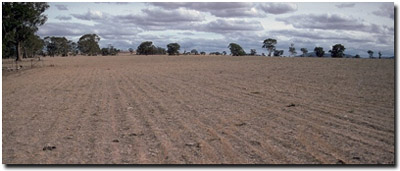 Soil Site LP 42 Landscape |
Soil Profile Morphology
Surface Soil
| A1 | 0-10 cm | Brown (7.5YR4/4); sandy loam; very firm consistence dry; pH 5.6: | 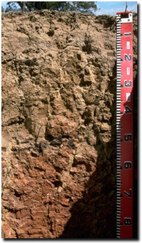 Soil Site LP42 Profile |
| A2 | 10-15 cm | Yellowish brown (10YR4/4) conspicuously bleached; fine sandy loam; structureless; strong consistence dry; contains a few (10%) ferruginous nodules (3-8 mm size) and a few (5%) quartz fragments (3-8 mm size); tends to form a hard capping above underlying columnar structure; pH 5.9; sharp change to: | |
| Subsoil | |||
| B21 | 15-50 cm | Yellowish brown (10YR5/6) with yellowish red (5YR4/6) diffuse mottles; light medium clay; strong very coarse columnar, parting to weak coarse blocky structure; rigid consistence dry; pH 7.1: | |
| B22 | 50-110 cm | Yellowish red (5YR5/8); light clay; moderate very coarse blocky structure; slickensides present; very strong consistence dry; pH 8.6: | |
| B3 | 110 cm + | Dark red (2.5YR4/6) and light grey (5YR7/1); light clay; moderate medium prismatic, parting down to moderate coarse blocky structure; strong consistence dry; contains a few (5%) quartz fragments (up to 10 cm size); pH 6.2. | |
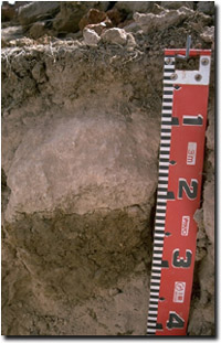 Columnar structure in upper | Key Profile Features
|
Key Profile Characteristics
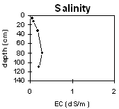
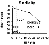
pH | Salinity Rating | |||
Surface (A1 horizon) | moderately acid | very low | non-sodic | none |
Subsurface (10 - 20 cm) | slightly alkaline | very low | strongly sodic | complete |
Subsoil (20 - 70 cm) | slightly acid | very low | strongly sodic | complete |
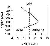 |  |  | |
Horizon | Horizon Depth | pH (water) | pH CaCl2 | EC 1:5 | NaCl | Exchangeable Cations | |||
Ca | Mg | K | Na | ||||||
Meq/100g | |||||||||
A1 | 0-10 | 5.6 | 4.4 | 0.1 | 2.3 | 2.2 | 0.3 | 0.1 | |
A2 | 10-15 | 5.9 | 4.5 | <0.05 | 0.7 | 1.2 | 0.1 | 0.4 | |
B21 | 15-50 | 7.1 | 4.7 | <0.05 | 3.7 | 8.6 | 0.9 | 3.4 | |
B22 | 50-110 | 8.6 | 4.7 | 0.05 | 4 | 8.8 | 0.2 | 6 | |
B3 | 110 | 6.2 | 5.4 | 0.11 | 1.8 | 6.1 | 0.1 | 3.30 | |
Horizon | Horizon Depth | Ex Al mg/kg | Ex Ac meq/100g | Field pF2.5 | Wilting Point pF4.2 | Coarse Sand (0.2-2.0mm) | Fine Sand (0.02-0.2mm) | Silt (0.002-0.02mm) | Clay (<0.002mm) |
A1 | 0-10 | 18.7 | 5.4 | ||||||
A2 | 10-15 | 12.6 | 3.5 | ||||||
B21 | 15-50 | 30.7 | 17.1 | ||||||
B22 | 50-110 | ||||||||
B3 | 110 |
Whole Profile
- Plant available water capacity (PAWC) is likely to be low. Effective rooting depth will be restricted by the dense and coarsely structured sodic subsoil.
- Organic matter is important for enhancing soil aggregation, fertility and water holding capacity. Organic matter levels will build up under pasture but will decline if cultivation takes place. Practices such as residue retention, minimum tillage and including pasture rotations should be utilised if cropping occurs.
- The bleached subsurface (A2) horizon indicates that periodic waterlogging occurs due to the slowly permeable subsoil.
- The surface soil has a low inherent fertility (based on the sum of the exchangeable basic cations).
- The low wilting point value for this soil suggests that plants will be able to utilise light rains falling when the soil is dry. However, if further rains do not occur the soil will become quite ‘droughty’.
- The dense and coarsely structured subsoil is strongly sodic, has a low Ca:Mg ratio, and is dispersive. As a result, root and water movement will be significantly restricted in the subsoil. After heavy rains, water will build up on top of the subsoil and waterlogging will result.
- The dispersive subsoil is prone to water erosion if exposed by removal of the surface soil. Maintaining a protective cover of surface soil and vegetation is important, especially on sloping land. Also, sodic soils present constraints for dam construction which need to be managed.
- The high levels of exchangeable sodium in the subsoil may also result in nutrient imbalances and may even have a toxic effect on some plants.
- The subsoil displays vertic properties (i.e. slickensides and deep cracking) that indicate that significant shrinking and swelling occurs in the deeper subsoil. This may have implications for engineering purposes (e.g. disturbance to fences and tree roots).
Profile described by Mark Imhof, Paul Rampant and Karen De Plater (22/3/95).