Victorian Resources Online (archived)
LP43
| Mapsheet: ST. ARNAUD | Aust. Soil Class.: Magnesic, Subnatric, Red SODOSOL |
| Northcote Factual Key: Dr 2.42 | Great Soil Group: red soloth |
| General Landscape Description: Midslope of hill. Original vegetation included Red Stringybark (Eucalyptus macrorhyncha) and Grey Box (E. microcarpa). | |
| Geology: Cambrian marine sediments (schistose, sandstone and shale). | |
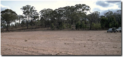 Soil Site LP 43 Landscape |
Soil Profile Morphology
Surface Soil
| A1 | 0-12 cm | Strong brown (7.5YR4/6); light fine sandy clay loam; hardsetting when dry; weakly structured; very firm consistence dry; contains a few (5%) ferruginous siltstone fragments and quartz gravel; pH 5.2; clear change to: | 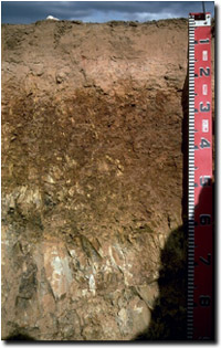 Soil Site LP43 Profile |
| A2 | 12-20 cm | Strong brown (7.5YR5/6) conspicuously bleached; light fine sandy clay loam; structureless; strong consistence (dry); pH 6.0; clear change to: | |
| Subsoil | |||
| B1 | 20-22 cm | Yellowish red (5YR5/8); clay loam (fine sandy); strong consistence dry; pH 6.2; abrupt change to: | |
| B21 | 22-40 cm | Dark red (2.5YR4/6); light medium clay; moderate medium to coarse blocky, parting to strong fine blocky structure; very strong consistence dry; pH 6.2; clear change to: | |
| B22 | 40-55 cm | Reddish brown (5YR5/4) and yellowish red (5YR5/6); light medium clay; moderate medium to coarse blocky, parting to strong fine blocky structure; strong consistence dry; contains a few (3%) siltstone fragments; pH 6.5: | |
| C | 55 cm + | Weathered rock. | |
Key Profile Features
- Strong texture contrast between surface (A) horizons and subsoil (B21) horizon.
Key Profile Characteristics
pH | Salinity Rating | |||
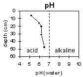
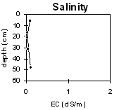
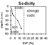
Surface (A1 horizon) | strongly acid | very low | non-sodic | none1 |
Subsoil (B21 horizon) | slightly acid | very low | sodic | slight2 |
Deeper subsoil (at 40-55 cm) | slightly acid | very low | sodic | moderate |
 |  |  | |
Horizon | Horizon Depth | pH (water) | pH CaCl2 | EC 1:5 | NaCl | Exchangeable Cations | |||
Ca | Mg | K | Na | ||||||
Meq/100g | |||||||||
A1 | 0-12 | 5.2 | 4.4 | 0.1 | 0.9 | 0.8 | 0.4 | 0.1 | |
A2 | 12-20 | 6 | 4.5 | <0.05 | 0.4 | 0.7 | 0.2 | 0.1 | |
B1 | 20-22 | 6.2 | 4.7 | <0.05 | 0.7 | 1.4 | 0.2 | 0.2 | |
B21 | 22-40 | 6.2 | 4.7 | 0.05 | 0.8 | 5.1 | 0.5 | 0.9 | |
B22 | 40-55 | 6.5 | 5.4 | 0.11 | 0.3 | 8.2 | 0.6 | 1.6 | |
Horizon | Horizon Depth | Ex Al mg/kg | Ex Ac meq/100g | Field pF2.5 | Wilting Point pF4.2 | Coarse Sand (0.2-2.0mm) | Fine Sand (0.02-0.2mm) | Silt (0.002-0.02mm) | Clay (<0.002mm) |
A1 | 0-12 | 25 | 6.8 | 21.8 | 4.8 | ||||
A2 | 12-20 | 18.5 | 3.8 | ||||||
B1 | 20-22 | ||||||||
B21 | 22-40 | 28.9 | 16.6 | ||||||
B22 | 40-55 |
Management Considerations:
Subsoil (A) Horizons
- The surface soil has a very low inherent fertility (based on the sum of the basic exchangeable cations). Building up organic matter levels will assist in improving soil fertility as well as aggregate stability and water holding capacity. Maintaining adequate surface cover is important on sloping land in order to prevent sheet erosion and loss of surface soil.
- The surface (A1) horizon disperses slightly after remoulding. This indicates that dispersion and resultant structural degradation (e.g. surface sealing, exacerbated hardsetting) may occur if the soil is cultivated in a moist to wet condition. Raindrop action on bare soil can have a similar effect, so it is important to maintain surface cover.
- The strongly acid surface soil indicates that some nutrients (e.g. aluminium) may become toxic. The level of exchangeable aluminium measured in the laboratory is, however, not high at this site (i.e. 25 ug/g) – but may affect highly aluminium-sensitive species. A pH/aluminium test sampled across the paddock may be most appropriate to determine if lime is needed to raise soil pH. Other factors need to be considered, however, before lime is recommended (e.g. species grown, method of application, local trial responses, soil surface structure and likely cost-benefit).
- Molybdenum deficiency may also occur in strongly acid soils. Lime application will make molybdenum more available to plants. Molybdenum is also applied in enriched superphosphate.
- The subsurface (A2) horizon disperses strongly after remoulding. This indicates that disturbance to this horizon (e.g. by cultivation) whilst in a moist-wet condition will result in structural degradation occurring and the possible development of a hardpan.
- The presence of a conspicuously bleached subsurface horizon indicates that periodic waterlogging occurs as water builds up on top of the slowly permeable subsoil after heavy rains.
- The subsoil is sodic and dispersive. This indicates that root and water movement will be restricted in the subsoil. Also, the dispersive subsoil will be highly erodible if exposed by removal of the surface horizons. Sodic soils also present constraints for dam construction which need to be managed.
- The subsoil is dominated by exchangeable magnesium (> 70%). This may result in nutrient imbalances (e.g. calcium and potassium deficiencies) and will enhance the deleterious effect of exchangeable sodium on soil structure.
Profile described by Mark Imhof, Paul Rampant and Karen De Plater (22/3/95).