Victorian Resources Online (archived)
LP44
| Property: State Forest | Geo. Ref: 701955E, 5909000N; ST ARNAUD |
| Aust. Soil Class.: Bleached, Magnesic, Red KUROSOL | Northcote Factual Key: Dr 3.41 |
| Great Soil Group: red soloth | Geology: Cambrian sediments. |
| General Landscape Description: Mid to upper slope (slope 20%) on mountain ridge located approximately 5 km east of Barkly. Vegetation includes Grey Box (E. microcarpa) and Red Stringybark (E. macrorhyncha). | |
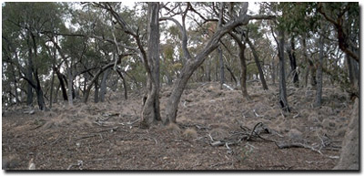 Soil Site LP 44 Landscape |
Soil Profile Morphology
Surface Soil
| A1 | 0-10 cm | Brown (7.5YR4/2); fine sandy loam; weak medium blocky structure; firm consistence dry; pH 5.0: | 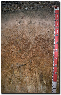 Soil Site LP44 Profile |
| A2 | 10-20 cm | Yellowish brown (10YR5/4) conspicuously bleached; fine sandy clay loam; structureless; contains very many (50%) angular quartz fragments; pH 5.1: | |
| Subsoil | |||
| B1 | 20-30 cm | Yellowish red (5YR5/8) and reddish yellow (5YR6/6); light medium clay; moderate medium to coarse polyhedral structure; strong consistence dry; pH 5.4: | |
| B21 | 30-60 cm | Dark red (2.5YR4/8); medium clay; strong medium to fine blocky structure; strong consistence dry; quartz floaters occur throughout; pH 5.4: | |
| B22 | 60-90 cm | Dark red (2.5YR4/8) and brownish yellow (10YR6/6); medium clay; strong medium to fine blocky structure; strong consistence dry; pH 5.6: | |
| C | 90 cm + | Weathered siltstone. | |
Key Profile Features
- Strong texture contrast between surface (A) horizons and subsoil (B21) horizon.
Key Profile Characteristics
pH | Salinity Rating | |||
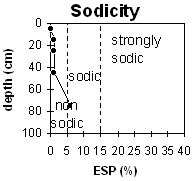
Surface (A1 horizon) | strongly acid | very low | non-sodic | none |
Subsoil (30 - 60 cm) | strongly acid | very low | non-sodic | none |
Deeper subsoil (60 - 90 cm) |
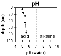 | 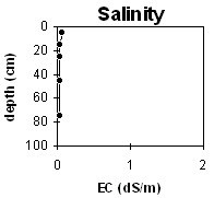 |  | |
Horizon | Horizon Depth | pH (water) | pH CaCl2 | EC 1:5 | NaCl | Exchangeable Cations | |||
Ca | Mg | K | Na | ||||||
Meq/100g | |||||||||
A1 | 0-10 | 5 | 4.2 | 0.07 | 4.4 | 1.9 | 0.6 | 0.1 | |
A2 | 10-20 | 5.1 | 4 | <0.05 | 0.1 | 0.5 | 0.2 | 0.1 | |
B1 | 20-30 | 5.4 | 4.2 | <0.05 | 0.1 | 2 | 0.4 | 0.1 | |
B21 | 30-60 | 5.4 | 4.2 | <0.05 | 0.1 | 4 | 0.5 | 0.2 | |
B22 | 60-90 | 5.6 | 4.3 | <0.05 | <0.1 | 4.6 | 0.4 | 0.3 | |
C | 90 | ||||||||
Horizon | Horizon Depth | Ex Al mg/kg | Ex Ac meq/100g | Field pF2.5 | Wilting Point pF4.2 | Coarse Sand (0.2-2.0mm) | Fine Sand (0.02-0.2mm) | Silt (0.002-0.02mm) | Clay (<0.002mm) |
A1 | 0-10 | 87 | 23.2 | ||||||
A2 | 10-20 | 159 | 9.4 | ||||||
B1 | 20-30 | 187 | 11.2 | ||||||
B21 | 30-60 | 304 | 15.6 | ||||||
B22 | 60-90 | ||||||||
C | 90 |
Management Considerations:
Whole Profile
- Exchangeable aluminium levels are high throughout the strongly acid soil profile (increasing with depth). These levels will significantly restrict the growth of aluminium-sensitive plant species.
- The surface horizons have a low inherent fertility (based on the sum of the exchangeable basic cations).
- Exchangeable magnesium levels are high (ie. greater than 80% of total cations) throughout the subsoil. This may result in nutrient imbalances (e.g. calcium and potassium deficiency).
- Profile described by Mark Imhof, Paul Rampant and Karen De Plater (23/3/95).