Victorian Resources Online (archived)
LP48
| Property: LP48 | Australian Soil Classification: Haplic, Hypercalcic, Red CHROMOSOL |
| Northcote Factual Key: Dr 2.23 | Great Soil Group: no suitable group |
| General Landscape Description: Mid to upper slope of a gently undulating rise within the Granite Highland Landscape Unit. The original vegetation includes Buloke (Casuarina luehmannii). | |
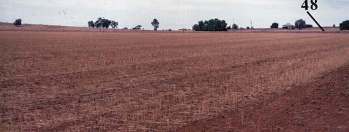 LP48 Landscape |
Soil Profile Morphology
Surface Soil
| A1 | 0-5 cm | Dark reddish brown (5YR3/4); heavy sandy loam; structureless and hardsetting surface condition; firm consistence dry; pH 7.9; clear change to: | 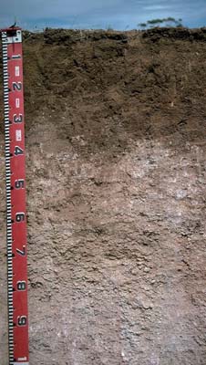 LP48 Profile |
| A2 | 5-20 cm | Reddish brown (5YR4/4); clay loam, (sandy); structureless; firm consistence dry; pH 8.4; clear and wavy change to: | |
| Subsoil | |||
| B21 | 20-35 cm | Red (2.5YR4/6); light medium clay; moderate medium polyhedral structure; very firm consistence dry; biological activity abundant (e.g. ants); pH 8.3; clear and wavy change to: | |
| B22k | 35-60 cm | Very many (80%) fine-earth carbonates and calcrete - incorporating some soil from above horizon in cracks; wavy change to: | |
| B23k | 60-90 cm | Reddish yellow (5YR6/6); sandy clay loam; contains very many (50%) coarse fragments of weathered granite and scattered fine-earth carbonates throughout: | |
| C | 90+ cm | Weathered granite. | |
NOTE: This soil corresponds to Terricks Sandy Loam (shallow phase) as described by Skene (1971). | |||
Key Profile Features
- Strong texture contrast between surface (A) horizons (clay content 25 to 33%) and subsoil (B21) horizon (clay content 57%).
- Hardsetting nature of the soil surface.
- Maximum carbonate accumulation in the 35-60 cm horizon (80% carbonates).
- Weathered granite beneath 90 cm.
Key Profile Characteristics
pH | Salinity Rating | |||
Surface (A1 horizon) | slightly alkaline | low | non-sodic | none |
Subsoil (B21 horizon) | moderately alkaline | low | non-sodic | none |
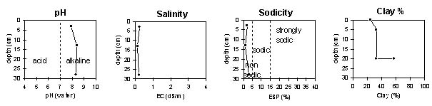 |
Horizon | Horizon Depth | pH (water) | EC 1:5 | NaCl | Exchangeable Cations | |||
Ca | Mg | K | Na | |||||
meq/100g | ||||||||
A1 | 0-5 | 7.9 | 0.24 | 9.2 | 0.9 | 1.6 | 0.2 | |
A2 | 5-20 | 8.4 | 0.14 | 12 | 1 | 1.5 | 0.1 | |
B21 | 20-35 | 8.3 | 0.23 | 15 | 2 | 1.6 | 0.4 | |
Horizon | Horizon Depth | Ex Al mg/kg | Ex Ac meq/100g | Field pF2.5 | Wilting Point pF4.2 | Coarse Sand (0.2-2.0mm) | Fine Sand (0.02-0.2mm) | Silt (0.002-0.02mm) | Clay (<0.002mm) |
A1 | 0-5 | 19.2 | 10.8 | 23 | 38 | 10 | 25 | ||
A2 | 5-20 | 21.5 | 12.6 | 18 | 34 | 10 | 33 | ||
B21 | 20-35 | 26.6 | 20 | 12 | 20 | 7 | 57 |
Management Considerations:
- In general, management strategies for all soils should aim to increase organic matter levels in the surface soil; minimise the degradation of soil aggregates and porosity; promote the development of stable biopores; improve the calcium status of the ion exchange complex (particularly when sodium is a significant part), and break up any hardpans. Less frequent tillage; using less aggressive implements, and working the soil at optimum moisture conditions can all assist in maintaining soil aggregation and porosity as well as reducing the breakdown of organic matter.
Surface (A) Horizons
- The surface horizon is hard-setting and moderately coherent; therefore it could restrict seedling emergence and may not be easy to work.
- The surface has a relatively low organic matter content. Improving soil surface organic matter levels will assist in minimising structural problems such as hardsetting, as well as improving soil fertility and water holding capacity.
Subsoil (B) Horizons
- The upper subsoil is non-sodic and non-dispersive. This is likely to present fewer limitations to root and water movement compared to more sodic subsoils in the region.
- The upper subsoil is moderately alkaline and becomes extremely alkaline at 35 cm. This indicates that phosphorus and some trace elements such as iron, manganese, zinc and copper may be poorly available to plants and deficiencies may occur. Deficiencies can be determined by plant tissue analysis. Boron toxicity can also occur in strongly alkaline soils.
Landholder Comments:
- Has not been cropped often. Oats have been grown once.
Notes:
Soil profile described by Mark Imhof, Paul Rampant and Karen de Plater (1/3/95)