Victorian Resources Online (archived)
LP53
| Property: LP53 Wanurp | Group: Pine Grove Farm Advance |
| Australian Soil Classification: Basic, Ferric, Orthic TENOSOL | Northcote Factual Key: Uc 5.21 |
| Great Soil Group: siliceous sand | |
| General Landscape Description: Recent alluvium within an older alluvial plain. Original vegetation includes River Red Gum (Eucalyptus camaldulensis). This soil is associated with prior stream activity. | |
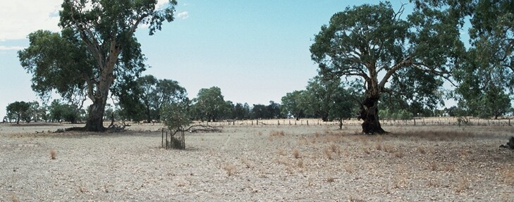 LP53 Landscape |
Soil Profile Morphology
Surface Soil
| A1 | 0-10 cm | Dark reddish brown (5YR3/4); heavy loamy sand; hardsetting surface condition; massive; firm consistence dry; pH 5.6; clear change to: | 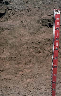 LP53 Profile |
| Subsoil | |||
| B21 | 10-30 cm | Dark reddish brown (5YR3/3); clayey sand; massive; very firm consistence dry; contains very few (2%) ferromanganiferrous nodules; pH 6.3; gradual change to: | |
| B31 | 30-65 cm | Strong brown (7.5YR5/6); clayey sand; massive; very firm consistence dry; contains very many (40%) ferromanganiferous nodules; pH 6.7; gradual change to: | |
| B32 | 65 cm+ | Reddish brown (7.5YR6/6); clayey sand; massive; firm consistence dry; contains very many (>50%) ferromanganiferrous nodules and very few (1%) rounded quartz fragments (3-4 mm); pH 7.1. | |
This soil corresponds to Type 1 soil of the prior stream landscape unit as described by Skene and Harford (1964). | |||
Key Profile Features
- Uniform sandy texture throughout the profile (clay percentage is less than 10% throughout).
Key Profile Characteristics
pH | Salinity Rating | |||
Surface (A1 horizon) | moderately acid | very low | non-sodic | none |
Subsoil (B21 horizon) | slightly acid | very low | non-sodic | none |
Deeper subsoil (at 75 cm) | slightly alkaline | very low | sodic | none |
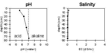 |
Horizon | Horizon Depth | pH (water) | EC 1:5 | NaCl | Exchangeable Cations | |||
Ca | Mg | K | Na | |||||
meq/100g | ||||||||
A1 | 0-10 | 5.6 | 0.13 | 2.4 | 0.9 | 0.4 | 0.1 | |
B21 | 10-30 | 6.3 | <0.05 | 2.1 | 0.9 | 0.3 | 0.1 | |
B32 | 30-65 | 6.7 | <0.05 | 1.3 | 0.9 | 0.2 | 0.1 | |
B32 | 65+ | 7.1 | <0.05 | 1.2 | 0.6 | 0.2 | 0.3 | |
Horizon | Horizon Depth | Ex Al mg/kg | Ex Ac meq/100g | Field pF2.5 | Wilting Point pF4.2 | Coarse Sand (0.2-2.0mm) | Fine Sand (0.02-0.2mm) | Silt (0.002-0.02mm) | Clay (<0.002mm) |
A1 | 0-10 | 11.1 | 5 | 51 | 30 | 9 | 9 | ||
B21 | 10-30 | 9.8 | 4.3 | 57 | 25 | 8 | 9 | ||
B32 | 30-65 | 8.8 | 4 | 58 | 25 | 9 | 9 | ||
B32 | 65+ |
Management Considerations:
- In general, management strategies for all soils should aim to increase organic matter levels in the surface soil; minimise the degradation of soil aggregates and porosity; promote the development of stable biopores; improve the calcium status of the ion exchange complex (particularly when sodium is a significant part – i.e. sodic), and break up any hardpans. Less frequent tillage; using less aggressive implements, and working the soil at optimum moisture conditions can all assist in maintaining soil aggregation and porosity as well as reducing the breakdown of organic matter. Practices such as residue retention, minimum tillage and including pasture rotations could be utilised if cropping takes place in order to build up organic matter, reduce erosion risk and increase fertility.
- Plant available water capacity (PAWC) is estimated to be very low (estimated at 45 mm) for this profile - based on the laboratory data available. PAWC is restricted by the high coarse sand and gravel content of the soil profile.
Surface (A) Horizons
- The sandy textured surface soil may be prone to wind erosion. Wind erodibility can be reduced by maintaining surface cover and organic matter levels. Improving soil organic matter levels will also assist in minimising structural problems such as hardsetting as well as improving aggregation, soil fertility and water holding capacity.
- Permeability of the sandy surface horizon will be high.
- The inherent fertility (based on the sum of the exchangeable basic cations) is very low for the surface soil.
- The water holding capacity of the surface soil is very low. However, due to the low wilting point, plants will be able to utilise light rains falling on relatively dry soil.
Subsoil (B) Horizons
- The subsoil has a very low nutrient status throughout.
- Plant available water holding capacity is low due to the high coarse sand and low clay content. This will limit pasture growth in a dry spring and summer, especially for shallow rooted species.