Victorian Resources Online (archived)
LP58
| Property: Mitiamo | Group: Pine Grove Farm Advance |
| Australian Soil Classification: Calcic, Hypernatric, Brown SODOSOL | Northcote Factual Key: Dy 2.43 |
| Great Soil Group: solodic | General Landscape Description: General Landscape Description: Generally lower lying position within an old alluvial plain. |
| Geology: Quaternary (Shepparton Formation) alluvial and aeolian deposits. | |
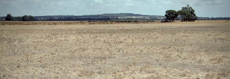 LP58 Landscape |
Soil Profile Morphology
Surface Soil
| A1 | 0-7 cm | Dark yellowish brown (10YR4/4); silty clay loam; hardsetting with surface cracking; weak blocky structure; firm consistence moist; pH 6.3; clear change to: | 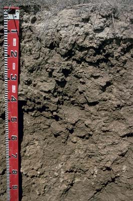 LP58 Profile |
| A2 | 7-10 cm | Yellowish brown (10YR5/4) conspicuously bleached (10YR7/1d); fine sandy clay loam; massive; strong consistence dry; pH 6.3; gradual change to: | |
| Subsoil | |||
| B21 | 10-50 cm | Yellowish brown (10YR5/4); light medium clay; strong coarse polyhedral structure; strong consistence dry; pH 8.2; gradual change to: | |
| B22 | 50-90 cm | Yellowish brown (10YR5/4); light medium clay; moderate coarse blocky structure; strong consistence moist; contains a few (5%) hard calcareous nodules; pH 9.3; gradual change to: | |
| B23 | 90 cm+ | Yellowish brown (10YR5/4); light medium clay; strong medium to coarse polyhedral structure; strong consistence dry; pH 8.9. | |
Key Profile Features
- Strong texture contrast between surface (A) horizon (clay content 32%) and the top of the subsoil (B21) horizon (clay content 66%).
- Hardsetting surface soil, with high fine sand (34%) and silt (34%) content.
- Coarsely structured sodic subsoil.
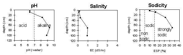
Key Profile Characteristics
pH | Salinity Rating | |||
Surface (A1 horizon) | slightly acidic | very low | sodic | slight1 |
Subsoil (B21 horizon) | moderately alkaline | very low | strongly sodic | complete |
Deeper subsoil (at 70 cm) | strongly alkaline | medium-high | strongly sodic | complete |
| 1 Strong dispersion after remoulding. | ||||
 |
Horizon | Horizon Depth | pH (water) | EC 1:5 | NaCl | Exchangeable Cations | |||
Ca | Mg | K | Na | |||||
meq/100g | ||||||||
A1 | 0-7 | 6.3 | 0.15 | 2.1 | 3.8 | 0.8 | 0.7 | |
A2 | 7-10 | 6.3 | 0.1 | 1.9 | 3.9 | 0.5 | 1.2 | |
B21 | 10-50 | 8.2 | 0.24 | 4.4 | 9 | 0.9 | 4.8 | |
B22 | 50-90 | 9.3 | 0.97 | 0.14 | 3.5 | 13 | 1 | 8.6 |
B23 | 90+ | 8.9 | 0.96 | 0.17 | 3.2 | 11 | 1 | 10 |
Horizon | Horizon Depth | Ex Al mg/kg | Ex Ac meq/100g | Field pF2.5 | Wilting Point pF4.2 | Coarse Sand (0.2-2.0mm) | Fine Sand (0.02-0.2mm) | Silt (0.002-0.02mm) | Clay (<0.002mm) |
A1 | 0-7 | 27.8 | 10.3 | 1 | 34 | 34 | 32 | ||
A2 | 7-10 | ||||||||
B21 | 10-50 | 37.4 | 20.8 | 0.3 | 14 | 22 | 66 | ||
B22 | 50-90 | ||||||||
B23 | 90+ |
Management Considerations:
- In general, management strategies for all soils should aim to increase organic matter levels in the surface soil; minimise the degradation of soil aggregates and porosity; promote the development of stable biopores; improve the calcium status of the ion exchange complex (particularly when sodium is a significant part – i.e. sodic), and break up any hardpans. Less frequent tillage; using less aggressive implements, and working the soil at optimum moisture conditions can all assist in maintaining soil aggregation and porosity as well as reducing the breakdown of organic matter. Practices such as residue retention, minimum tillage and including pasture rotations could be utilised if cropping takes place in order to build up organic matter, reduce erosion risk and increase fertility.
- Plant available water capacity (PAWC) is estimated to be low (estimated at 65 mm) for this profile - based on the laboratory data available. Effective rooting depth will be limited by the strongly sodic subsoil.
Surface (A) Horizons
- The surface soil has a low overall nutrient status (based on the sum of the exchangeable basic cations).
- The surface soil is sodic and disperses slightly in water. However, when remoulded it disperses strongly which indicates that over cultivation or overstocking of the soil in a wet condition may result in dispersion and crust formation occurring. The hardsetting condition will also be exacerbated.
- Improving surface soil organic matter levels will assist in minimising structural problems such as crusting and dispersion as well as improving soil fertility and water holding capacity.
Subsoil (B) Horizons
- The top of the subsoil is strongly sodic (and also has a low calcium:magnesium ratio) and disperses completely in water. This is likely to result in restricted water and root movement through the profile. The conspicuously bleached surface (A2) horizon indicates that water movement is being restricted and that periodic waterlogging may occur.
- The subsoil salinity rating becomes medium at 50 cm depth in the profile. This may restrict the growth of salt sensitive species (e.g. maize and many legumes).