Victorian Resources Online (archived)
LP66
| Group: Glenloth East Farm Advance Group | Australian Soil Classification: Epicalcareous, Self-Mulching; Grey VERTOSOL |
| Northcote Factual Key: Ug 5.2 | Great Soil Group: grey clay |
| General Landscape Description: Active flood plain of Avoca River. Gilgai ("crabholey") microrelief present. Original vegetation included Black Box (Eucalyptus largiflorens). Watertable occurs at approximately 7 m. depth. | |
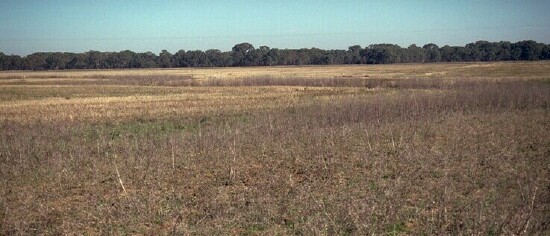 LP66 Landscape |
Soil Profile Morphology
Surface Soil
| A11 | 0-10 cm | Dark greyish brown (10YR4/2); light clay; weak consistence moist; self mulching surface condition with surface flake; pH 7.8; clear change to: | 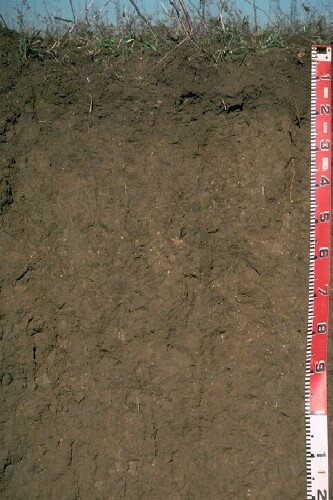 LP66 Profile |
| A12 | 10-30 cm | Dark greyish brown (10YR4/2); light medium clay; weak consistence moist; weak fine platy fragmentation present; pH 7.7; clear and wavy change to: | |
| Subsoil | |||
| B21k | 30-70 cm | Greyish brown (10YR5/2); medium heavy clay; moderate coarse prismatic, breaking down to coarse blocky structure; very firm consistence dry; contains a few (5-10%) carbonate nodules (up to 10 mm diameter); pH 8.4; gradual change to: | |
| B22 | 70+ cm | Greyish brown (2.5YR5/2); medium heavy clay; slickensides present; contains a few (2%) carbonate nodules; pH 8.7. | |
| Note: The soil is likely to vary across the paddock in relation to the gilgai microrelief. Amounts of carbonates and salts are usually higher in the gilgai mounds than in the depressions. | |||
Key Profile Features
- Self mulching surface soil.
- Clay texture throughout profile.
- Vertic properties (ie. cracking, slickensides).
- Soil profile is alkaline throughout.
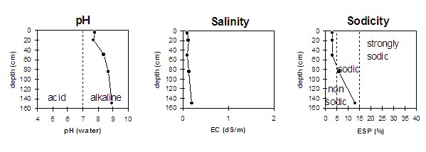
Soil Profile Characteristics
pH | Salinity Rating | |||
Surface (A1 horizon) | slightly alkaline | very low | non-sodic | none1 |
Subsoil (B21 horizon) | moderately alkaline | very low | non-sodic | none |
Deeper subsoil (at 1 m) | strongly alkaline | low | sodic | slight-moderate |
| 1 Slight dispersion after remoulding. | ||||
 |
Management Considerations:
Wole Profile:
- Plant available water capacity (PAWC) is considered to be relatively high (estimated at approximately 175 mm) for this soil profile. This is based on available laboratory data and assumes an effective rooting depth of 140 cm.
- Soluble salt levels are low throughout the profile. Irregular flooding may assist in restricting the upward movement of subsoil salts. More frequent flooding may contribute to rising water tables.
Surface (A) Horizons
- The surface soil has a relatively high cation exchange capacity. Inherent fertility is high.
- The high wilting point value indicates that plants will be unable to utilise light rains falling on relatively dry soil.
- The organic matter levels are satisfactory for a clay cropping soil. The total nitrogen level is relatively low at this site, suggesting that the rotation may need to be changed when economically possible. Cracking clay soils tend to mineralise nitrogen readily in cultivated bare fallows but total nitrogen levels are rapidly diminished under cropping. On clay soils in the Wimmera, cereals and legumes (including medic pastures) often respond to addition of zinc.
- Tillage of cracking clay soils should be avoided if the soil is wet (ie. wetter than the plastic limit). At such moisture conditions, tillage and excessive trafficking or overstocking could result in structural damage (e.g. compaction, smearing) occurring. Ideally tillage and trafficking should take place when the soil is drier than the plastic limit, down to at least the tillage depth. The presence of some fine platey fragmentation in the subsurface (A12) horizon at this site indicates that some compaction may have occurred. This horizon also disperses slightly. This is another reason why tillage should be avoided when the soil is wet.
- The surface soil is self-mulching which provides a good seed bed which is friable and easily worked. It will, however, become sticky when wet. It has been noted by Badawy (1984) that the cereal cyst nematode "eelworm" is more likely to occur on friable clays than the non-friable clays.
- When the soil is dry, heavy rains will move down the soil cracks. This rapid recharge can be valuable for the survival of plants near wilting. When wet, the soil will swell and further infiltration of water will be relatively slow.
Subsoil (B) Horizons
- The upper subsoil is non-sodic, this is a good result as sodicity may impede water and root movement
- The deeper subsoil is sodic and has a low calcium : magnesium ratio (0.8). As a result dispersion occurs which leads to structural conditions restricting root and water movement at depth (ie. beyond 140 cm).
Comments from Landholder
- Holds water in a drought (at 30-40 cm depth).
- Receives heavy flooding in most years.
- Referred to as "black river soil" locally.