Victorian Resources Online (archived)
LP72
| Group: Oakvale Farm Advance Group | Australian Soil Classification: Epihypersodic, Pedal, Hypercalcic CALCAROSOL |
| Northcote Factual Key: Dy 2.23 | Great Soil Group: no suitable group |
| General Landscape Description: Long flat slope of a plain associated with a subdude Cannie Ridge. Native Vegetation: Included Red Mallee (E. socialis) and Square Fruited Mallee (E. Calycogona). | |
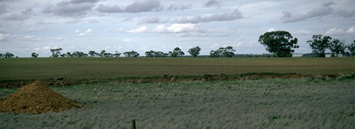
LP72 Landscape
Soil Profile Morphology
Surface Soil
| A1 | 0-10 cm | Dark reddish brown (5YR3/2); sandy clay loam; weakly structured; weak consistence moist; pH 8.0; abrupt change to: | 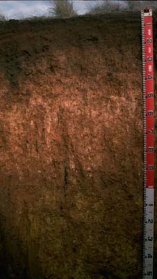 LP72 Profile |
| Subsoil | |||
| B1 | 10-20 cm | Dark reddish brown (5YR4/4); sandy clay; weak coarse blocky structure; firm consistence moist; pH 8.9; sharp change to: | |
| B21 | 20-35 cm | Yellowish red (5YR5/6); medium clay; moderate sub-angular blocky structure; strong consistence dry; pH 9.5; clear and wavy change to: | |
| B22k | 35-100 cm | Yellowish red (5YR5/6); medium clay (sandy); moderate sub-angular blocky structure; strong consistence dry; contains a few (2%) carbonate nodules (up to 10 mm in diameter) and many (45%) soft carbonates in tongues, as well as a few (2%) sandstone gravels (up to 15 mm diameter); pH 9.6; gradual and wavy change to: | |
| BC | 100 + cm | Yellowish red (7.5YR5/6); medium clay (sandy); moderate sub-angular blocky structure; strong consistence dry; pH 8.5; mixed with weathered sandstone. | |
Key Profile Features
- Moderate texture contrast between surface (A1) horizon and subsoil (B) horizons.
- Sodic
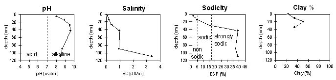
Key Profile Characteristics
pH | Salinity Rating | |||
Surface (A1 horizon) | moderately alkaline | very low | non-sodic | none1 |
Subsoil (25-45 horizon) | very strongly alkaline | low | sodic | slight |
Deeper subsoil (1 m) | moderately alkaline | extremely high | strongly sodic | none2 |
| 1 Slight dispersion with remoulding. 2 Due to high soluble salt levels. | ||||
 |
Horizon | Horizon Depth | pH (water) | pH CaCl2 | EC 1:5 | NaCl | Exchangeable Cations | |||
Ca | Mg | K | Na | ||||||
meq/100g | |||||||||
A1 | 0-10 | 8 | 7.1 | 0.09 | 9 | 4 | 1.1 | 0.3 | |
B1 | 10-20 | 8.9 | 8.2 | 0.19 | 11 | 9.6 | 0.8 | 1.1 | |
B21 | 2-35 | 9.5 | 8.6 | 0.39 | <0.05 | 5.9 | 12 | 1 | 3 |
B22K | 35-50 | 9.6 | 8.9 | 0.99 | 0.11 | 5 | 10 | 1.2 | 8.3 |
B22K | 80-100 | 8.7 | 8 | 0.95 | 0.12 | 1 | 5.8 | 0.6 | 4.2 |
BC | 100+ | 8.5 | 8.3 | 3.4 | 0.49 | 6.3 | 10 | 1.1 | 11 |
Horizon | Horizon Depth | Ex Al mg/kg | Ex Ac meq/100g | Field pF2.5 | Wilting Point pF4.2 | Coarse Sand (0.2-2.0mm) | Fine Sand (0.02-0.2mm) | Silt (0.002-0.02mm) | Clay (<0.002mm) |
A1 | 0-10 | 17.4 | 10.4 | 36 | 34 | 4 | 23 | ||
B1 | 10-20 | 37.3 | 23.4 | 30 | 23 | 4 | 35 | ||
B21 | 2-35 | 30.2 | 19 | 11 | 24 | 7 | 51 | ||
B22K | 35-50 | 35.7 | 21.4 | 25 | 18 | 4 | 35 | ||
B22K | 80-100 | 25 | 14 | 4 | 36 | ||||
BC | 100+ |
Management Considerations:
Surface (A) Horizons
- The surface soil is non-sodic but disperses moderately after remoulding. Overstocking or excessive cultivation of the soil when wet may result in surface sealing and exacerbate the hardsetting condition
- The overall nutrient status is high (based on the sum of the exchangeable basic cations). Total nitrogen and organic carbon levels are relatively low.
Subsoil (B) Horizons
- The subsoil is sodic (becoming strongly sodic with depth). This is likely to result in restricted root and water movement throughout the profile. The B1 horizon (10-20 cm) disperses strongly after remoulding, so tillage in a moist to wet condition is likely to result in structural degradation (eg. plough pan development).
- The very strongly alkaline subsoil (becoming extremely alkaline at 35 cm depth) indicates that some nutrients (e.g. copper, iron, manganese and zinc) may be poorly available to plants.
- The salinity rating becomes medium-high at 35 cm depth. This is likely to restrict the growth of salt sensitive species such as linseed, maize, chickpeas, faba beans and some other legumes.
- The B/C horizon (from 100 cm depth) has a very high salinity rating for plant growth.
Notes
- Repeats of analyses are being undertaken for some of the horizons at this site, due to some irregular results.
- Profile described by Mark Imhof, Paul Rampant and Sonia Thompson (25/5/95)