Victorian Resources Online (archived)
LP80
| Group: Navarre and Districts Landcare Group | Map Sheet: ST ARNAUD |
| Aust. Soil Class.: Bleached, Eutrophic, Red CHROMOSOL | Northcote Factual Key: Dy 2.42 |
| General Landscape Description: Lower alluvial terrace. | Geology: Quaternary alluvial deposits (Shepparton Formation) |
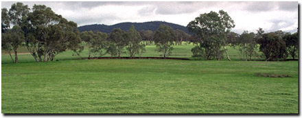 Soil Site LP 80 Landscape |
Soil Profile Morphology
Surface Soil
| A11 | 0-12 cm | Brown (7.5YR4/4); fine sandy loam; massive; weak consistence moist; pH 5.3; clear change to: | 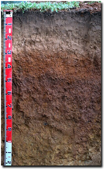 Soil Site LP80 Profile |
| A2 | 12-25 cm | Conspicuously bleached; light fine sandy loam; structureless; weak consistence moist; pH 5.4; abrupt change to: | |
| Subsoil | |||
| B1 | 25-30 cm | Yellowish red (5YR5/8); fine sandy clay loam; weak medium blocky structure; firm consistence moist; pH 5.4; abrupt change to: | |
| B21 | 30-45 cm | Yellowish red (5YR5/8); medium clay; moderate medium blocky, parting to fine blocky structure; firm consistence moist; pH 6.1 abrupt and wavy change to: | |
| B22 | 45-65 cm | Yellowish red (5YR4/6); medium heavy clay; weak coarse blocky, parting to moderate fine blocky structure; firm consistence moist; pH 6.7; gradual change to: | |
| B23 | 65-90 cm | Strong brown (7.5YR5/6); medium clay; strong medium blocky, parting to fine blocky structure; firm consistence moist; pH 7.0; gradual change to: | |
| B3 | 90+ cm | Strong brown (7.5YR5/6) with yellowish red (5YR5/6) and red (2.5YR5/8) mottles; very fine sandy clay loam; weakly structured; very firm consistence slightly moist; pH 7.3. | |
Key Profile Features
- Strong texture contrast between surface (A) horizon and the upper subsoil (B21) horizon.
Key Profile Characteristics
pH | Salinity Rating | |||
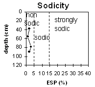
Surface (A1 horizon) | strongly acid | low | non-sodic | - |
Subsoil (B21 horizon) | strongly acid | very low | non-sodic | none1 |
Deeper subsoil (at 90 cm) | slightly alkaline | very low | non-sodic | - |
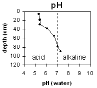 | 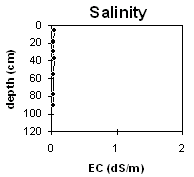 |  | |
Horizon | Horizon Depth | pH (water) | pH CaCl2 | EC 1:5 | NaCl | Exchangeable Cations | |||
Ca | Mg | K | Na | ||||||
Meq/100g | |||||||||
A11 | 0-12 | 5.3 | 4.3 | 0.05 | 1.3 | 0.4 | 0.3 | <0.1 | |
A12 | 12-25 | 5.4 | 4.4 | <0.05 | 0.4 | 0.1 | 0.2 | <0.1 | |
B1 | 25-30 | 5.4 | 4.4 | <0.05 | 1.8 | 0.7 | 0.4 | <0.1 | |
B21 | 30-45 | 6.1 | 5.3 | 0.05 | 3.7 | 1.9 | 0.6 | 0.1 | |
B22 | 45-65 | 6.7 | 5.7 | <0.05 | 5.1 | 3.4 | 0.7 | 0.1 | |
B23 | 65-90 | 7.0 | 6.0 | <0.05 | 4.4 | 3.7 | 0.6 | 0.2 | |
B24 | 90 | 7.3 | 6.2 | <0.05 | 2.5 | 1.9 | 0.3 | 0.1 | |
Horizon | Horizon Depth | Ex Al mg/kg | Ex Ac meq/100g | Field pF2.5 | Wilting Point pF4.2 | Coarse Sand (0.2-2.0mm) | Fine Sand (0.02-0.2mm) | Silt (0.002-0.02mm) | Clay (<0.002mm) |
A11 | 0-12 | 19 | 5.4 | ||||||
A12 | 12-25 | 25 | 1.4 | ||||||
B1 | 25-30 | 32 | 4.1 | ||||||
B21 | 30-45 | ||||||||
B22 | 45-65 | ||||||||
B23 | 65-90 | ||||||||
B24 | 90 |
Management Considerations:
Whole Profile
- Plant available water capacity (PAWC) will be reasonable for this soil due to the relatively deep effective rooting depth.
- The strongly acid surface soil indicates that some nutrients (eg. aluminium, manganese) may become toxic to plants. Some plant species such as lucerne and phalaris are sensitive to significant levels of aluminium. The level of exchangeable aluminium measured in the laboratory is, however, not high at this pit site (ie. 19-32 ug/g) but may affect highly aluminium-sensitive species. A pH/aluminium test, sampled across the paddock, may be most appropriate to determine if lime is needed to raise soil pH. Other factors need to be considered, however, before lime is recommended (e.g. pasture species grown, method of application, local trial responses, soil surface structure and likely cost/benefit).
- Deficiencies in molybdenum, phosphorus and potassium may occur in strongly acid soils. Lime application may assist in increasing phosphorus availability. Plant tissue analysis may give a more accurate assessment of molybdenum requirements.
- The inherent fertility (based on the sum of the exchangeable basic cations) is low for the surface horizons.
- The upper subsoil is non-sodic, has a favourable calcium:magnesium ratio (ie. 2:1), and is reasonably well structured (parting to fine blocky peds). Root and water movement should be relatively good as a result.
- The pH increases with depth down the subsoil. As a result nutrient toxicities (e.g. aluminium) are less likely to occur in the subsoil.
- Regarded as some of the best soil on the property; stocked at 4-5 sheep per acre.
- Will grow any crop.
- Profile described by Mark Imhof, Paul Rampant and Karen De Plater (5/6/95).