Victorian Resources Online (archived)
LP83
| Group: Navarre and Districts Landcare Group | Map Sheet: ST ARNAUD |
| Aust. Soil Class.: Haplic, Mesotrophic, Red CHROMOSOL | Northcote Factual Key: Dr 2.21 |
| General Landscape Description: Crest of hill (11% slope) on Rolling Hills landform pattern. Original vegetation included Red Stringybark (Eucalyptus macrorhyncha). | |
| Geology: Cambrian sediments. (sandstone and slate). | |
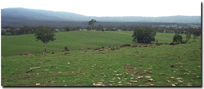 Soil Site LP 83 Landscape |
Soil Profile Morphology
Surface Soil
| A1 | 0-10 cm | Dark reddish brown (5YR3/3); sandy loam; weak medium blocky structure; very weak consistence dry; contains many (25%) sandstone fragments (7 mm average diameter); pH 5.7; abrupt change to: | 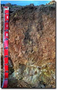 Soil Site LP83 Profile |
| A2 | 10-25 cm | Reddish brown (5YR4/4); fine sandy clay loam; weak medium blocky, parting down to moderate fine polyhedral structure; weak consistence dry; contains many (25%) fine sandstone fragments (10 mm average diameter); pH 6.2; clear change to: | |
| Subsoil | |||
| B1 | 25-60 cm | Yellowish red (5YR4/6); medium clay; moderate medium polyhedral, parting to strong fine polyhedral structure; firm consistence dry; contains very few (< 2%) soft and hard manganiferous segregations (6-8 mm diameter); and many (50%) fine sandstone fragments (up to 100 mm diameter); pH 5.9; gradual change to: | |
| BC | 60+ cm | Mainly sandstone (90%). Contains (10%) yellowish red (5YR5/8); medium clay; contains very few (<2%) soft and hard manganiferous segregations (6-8 mm diameter), and very many (90%) fine sandstone fragments. | |
Key Profile Features
- Strong texture contrast between surface (A) horizon and the upper subsoil (B21) horizon.
- Shallow soil profile.
Key Profile Characteristics
pH | Salinity Rating | |||
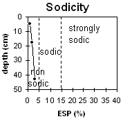
Surface (A1 horizon) | moderately acid | low | non-sodic | none1 |
Subsoil (B21 horizon) | moderately acid | very low | non-sodic | slight |
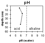 | 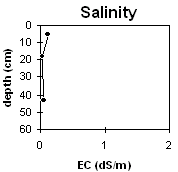 |  | |
Horizon | Horizon Depth | pH (water) | pH CaCl2 | EC 1:5 | NaCl | Exchangeable Cations | |||
Ca | Mg | K | Na | ||||||
Meq/100g | |||||||||
A1 | 0-10 | 5.7 | 4.9 | 0.11 | 7.7 | 2.2 | 0.6 | 0.1 | |
B1 | 10-25 | 6.2 | 5.3 | <0.05 | 3.5 | 1.8 | 0.4 | <0.1 | |
B21 | 25-60 | 5.9 | 4.9 | 0.04 | 0.6 | 2.9 | 0.3 | 0.1 | |
Horizon | Horizon Depth | Ex Al mg/kg | Ex Ac meq/100g | Field pF2.5 | Wilting Point pF4.2 | Coarse Sand (0.2-2.0mm) | Fine Sand (0.02-0.2mm) | Silt (0.002-0.02mm) | Clay (<0.002mm) |
A1 | 0-10 | 36.2 | 10.3 | 18 | 37 | 29 | 16 | ||
B1 | 10-25 | 27.5 | 7.9 | 11 | 41 | 29 | 18 | ||
B21 | 25-60 | 26.8 | 10.4 | 13 | 26 | 25 | 32 |
Management Considerations:
Whole Profile
- Plant available water capacity (PAWC) is likely to be quite low for soils such as these that are shallow and contain large amounts of coarse fragments.
- Exchangeable calcium levels are relatively high in the moderately acid surface horizon – suggesting that lime has been applied and that natural pH levels have been increased.
- Organic carbon and total nitrogen levels are reasonably high at this site. This is a good result as organic matter enhances the fertility, aggregate stability and water holding capacity of surface soils.
- The subsoil has a low inherent fertility (based on the sum of the exchangeable basic cations).
- The soil profile will be reasonably well draining and these areas are likely to be significant recharge areas.
- Improved pasture with Phalaris and Cocksfoot.
- Stocked at 11/2 - 2 sheep per acre.
- Lower in the landscape, this country is susceptible to erosion and salinity.
- Very deficient in potassium.
- Molybdenum applied with superphosphate every 7 years.
Profile described by Paul Rampant, Sonia Thompson and Ruth Lourey (5/6/95).