Victorian Resources Online (archived)
LP87
| Group: Raywood Farm Advance Group | Australian Soil Classification: Hypocalcic, Mesonatric, Red SODOSOL |
| Northcote Factual Key:Dr 2.13 | Great Soil Group: red-brown earth |
| General Landscape Description: Old alluvial plain. | |

LP87 Landscape
Soil Profile Morphology
Surface Soil
| A11 | 0-5 cm | Dark brown (7.5YR4/4); very finesandy clay loam;hardsetting surface condition; weak blocky structure; firm consistence moist; pH 6.1; clear change to: | 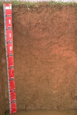 LP87 Profile |
| A12 | 5-12 cm | Dark brown (7.5YR4/4) (with yellowish red (5YR4/6) mixing); very fine sandy clay loam; weak blocky structure; weak consistence moist; pH 6.4; clear change to: | |
| Subsoil | |||
| B21 | 12-30 cm | Yellowish red (5YR4/6); mediumheavy clay; strong coarse blocky structure (with shiny faced peds); very firm consistence moist; pH 7.3; clear change to: | |
| B22 | 30-65 cm | Yellowish red (5YR5/6); medium clay; firm consistence moist; pH 8.8; gradual change to: | |
| B23 | 65+ cm | Strong brown (7.5YR5/6); mediumclay; parting to strong polyhedral structure; weak consistence moist; contains a few (<2%) carbonates (5-10 mm diameter) in pockets; pH 9.0. | |
Key Profile Features
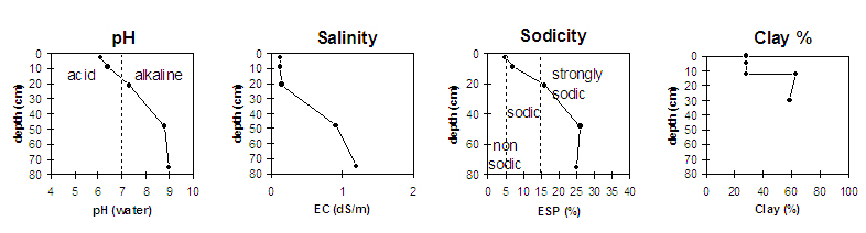
- Strong texture contrast between surface (A) horizons (28% clay) and the top of the subsoil (B21) horizon (63% clay).
- Strongly sodic subsoil.
Key Profile Characteristics
pH | Salinity Rating | |||
Surface (A1 horizon) | slightly acid | low | non-sodic | slight1 |
Subsoil (B21 horizon) | slightly alkaline | very low | strongly sodic | moderate - strong |
Deeper subsoil (at 1 m) | strongly alkaline | high | strongly sodic | moderate-strong |
| 1 Moderate to strong dispersion after remoulding. | ||||
 |
Horizon | Horizon Depth | pH (water) | EC 1:5 | NaCl | Exchangeable Cations | ||||
Ca | Mg | K | Na | ||||||
meq/100g | |||||||||
A1 | 0-5 | 6.1 | 5.1 | 0.13 | 2.1 | 3.4 | 0.7 | 0.3 | |
A12 | 5-12 | 6.4 | 5.2 | 0.13 | 1.8 | 3.4 | 0.6 | 0.4 | |
B21 | 12-30 | 7.3 | 6.2 | 0.15 | 3.4 | 8.5 | 1.3 | 2.5 | |
B22 | 30-65 | 8.8 | 8 | 0.91 | 0.15 | 3.6 | 13 | 1.2 | 6 |
B23 | 65+ | 9 | 8.5 | 1.2 | 0.21 | 3.6 | 14 | 1.5 | 6.1 |
Horizon | Horizon Depth | Ex Al mg/kg | Ex Ac meq/100g | Field pF2.5 | Wilting Point pF4.2 | Coarse Sand (0.2-2.0mm) | Fine Sand (0.02-0.2mm) | Silt (0.002-0.02mm) | Clay (<0.002mm) |
A1 | 0-5 | 25 | 9.6 | 2 | 41 | 26 | 28 | ||
A12 | 5-12 | 22.2 | 8.9 | 2 | 41 | 26 | 28 | ||
B21 | 12-30 | 32.2 | 19 | 1 | 20 | 14 | 63 | ||
B22 | 30-65 | 36.9 | 20.8 | 1 | 19 | 19 | 59 | ||
B23 | 65+ |
Management Considerations
Whole Profile
- Plant Available Water Capacity (PAWC) is considered to be relatively low (estimated at approximately 80 cm) for this site. This is based on available laboratory data and assumes an effective rooting depth of 40 cm. Rooting depth will be limited by the level of soluble salts in the deeper strongly sodic subsoil.
Surface (A) Horizon
- Total nitrogen and organic carbon levels are reasonable (as would be expected in an area that has been in pasture for a number of years).
- When dry, the surface soil will set hard and may be difficult to work. When worked in a dry condition, it will become "powdery" and then may be prone to structural degradation from raindrop action. Improving organic matter will help improve soil structure. If cultivated in a wet condition, dispersion may occur which could result in surface sealing developing which would restrict water infiltration and seedling emergence.
- The surface (A1 horizon) soil disperses slightly in water (moderately to strongly after remoulding). This indicates that mechanical disturbance to this horizon whilst in a wet condition may result in structural deterioration and exacerbate the hardsetting condition.
- The subsurface (A12) horizon disperses strongly after remoulding. Mechanical disturbance to this horizon whilst in a moist to wet condition may result in the development of a cultivation pan.
Subsoil (B) Horizons
- The coarsely structured upper subsoil is strongly sodic and has a low calcium:magnesium ratio (i.e. <1). It also disperses moderately to strongly in water. This is likely to result in water and root movement being restricted throughout the profile.
- The salinity rating becomes high at 30 cm depth. This may restrict the growth of salt sensitive species (e.g. maize, linseed and faba beans). These high levels of soluble salts may be due to seepage from a nearby channel.
- The deeper subsoil is strongly alkaline (from 30 cm depth), which indicates that some nutrients (e.g. phosphorus, iron, manganese and zinc) may be poorly available to plants.
Notes
- Profile described by Mark Imhof, Paul Rampant and Karen De Plater (6/7/95).