Victorian Resources Online (archived)
LP88
| Group: Raywood Farm Advance Group | Australian Soil Classification: Hypocalcic, Mesonatric, Red SODOSOL. |
| Northcote Factual Key:Dr 2.13 | Great Soil Group: red-brown earth |
| General Landscape Description: Old alluvial plain. | |
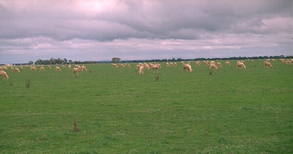 LP88 Landscape |
Soil Profile Morphology
Surface Soil
| A1 | 0-10 cm | Dark brown (7.5YR4/4); very fine sandy clay loam; hardsetting surface condition; weak coarse blocky structure; strong consistence dry; pH 6.2; abrupt change to: | 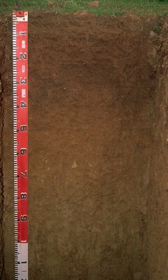 LP88 Profile |
| Subsoil | |||
| B21 | 10-40 cm | Yellowish red (5YR4/4); medium clay; strong coarse blocky, parting to strong fine polyhedral structure (with shiny faced peds); very strong consistence dry; pH 7.9; clear change to: | |
| B22 | 40-65 cm | Yellowish red (5YR5/6); medium heavy clay; firm consistence moist; pH 9.0; clear change to: | |
| B23 | 65-90 cm | Yellowish brown (10YR5/6) and yellowish red (5YR5/6); medium clay; moderate fine polyhedral structure; very strong consistence dry; contains few (2%) carbonate nodules (up to 15 mm diameter); pH 9.1; gradual change to: | |
| B24 | 90+ cm | Yellowish brown (10YR5/6) and strong brown (7.5YR5/6); medium clay; strong fine polyhedral structure; very strong consistence dry; contains very few (<1%) carbonate nodules (up to 30 mm diameter); pH 9.1. | |
Key Profile Features
- Strong texture contrast between the surface (A) horizon (26% clay) and the top of the subsoil (B21) horizon (73% clay).
- Strongly sodic subsoil.
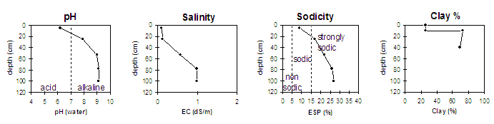
Key Profile Characteristics
pH | Salinity Rating | |||
Surface (A1 horizon) | slightly acid | very low | sodic | slight1 |
Subsoil (B21 horizon) | slightly alkaline | very low | strongly sodic | strong |
Deeper subsoil (at 1 m) | very strongly alkaline | medium | strongly sodic | strong |
| 1 Strong to complete dispersion after remoulding. | ||||
 |
Horizon | Horizon Depth | pH (water) | EC 1:5 | NaCl | Exchangeable Cations | ||||
Ca | Mg | K | Na | ||||||
meq/100g | |||||||||
A1 | 0-10 | 6.2 | 5.1 | 0.1 | 2.4 | 2.4 | 0.87 | 0.5 | |
B21 | 10-40 | 7.9 | 6.5 | 0.12 | 6.6 | 9.9 | 1.6 | 3.5 | |
B22 | 0-65 | 9 | 7.9 | 0.58 | 0.05 | 5.6 | 13 | 1.6 | 5.7 |
B23 | 65-90 | 9.1 | 8.3 | 0.99 | 0.12 | 4.8 | 12 | 1.6 | 6.4 |
B24 | 90+ | 9.1 | 8.3 | 0.99 | 0.14 | 4.6 | 13 | 1.5 | 6.9 |
Horizon | Horizon Depth | Ex Al mg/kg | Ex Ac meq/100g | Field pF2.5 | Wilting Point pF4.2 | Coarse Sand (0.2-2.0mm) | Fine Sand (0.02-0.2mm) | Silt (0.002-0.02mm) | Clay (<0.002mm) |
A1 | 0-10 | 23.6 | 9.4 | 5 | 39 | 28 | 26 | ||
B21 | 10-40 | 39 | 22.7 | 1 | 13 | 12 | 73 | ||
B22 | 0-65 | 40.1 | 21.8 | 1 | 14 | 15 | 69 | ||
B23 | 65-90 | 38 | 21.2 | 1 | 14 | 16 | 62 | ||
B24 | 90+ |
Whole Profile
- Plant Available Water Capacity (PAWC) is considered to be relatively medium (estimated approximately at 120 mm) for this site. This is based on available laboratory data and assumes an effective rooting depth of 60 cm. Rooting depth will be restricted by the strongly sodic deeper subsoil and by the medium level of soluble salts.
Surface (A) Horizon
- The surface soil has a low overall nutrient status and the total nitrogen and organic carbon levels are moderate. Organic matter levels will have improved after three years of pasture growth. Improving organic matter levels is important for soils with high fine sand (39%) and silt (28%) contents. Such soils with low organic matter levels will set hard on drying and become difficult to work. It may become "powdery" when worked in a dry condition.
- The surface soil is sodic and will disperse after remoulding. Excessive cultivation or overstocking of the soil in a wet condition is likely to cause dispersion and may result in the development of surface sealing and exacerbate the hardsetting condition. Gypsum is usually an effective ameliorant on such soils. The use of gypsum will result in improved water infiltration and seedling emergence.
Subsoil (B) Horizons
- The coarsely structured upper subsoil is strongly sodic and disperses strongly in water. This is likely to result in water and root movement being significantly restricted. Deep tillage with gypsum application has been advocated as an ameliorative technique for some subsoils. A test strip in the paddock could be used to asses this technique.
- The salinity rating becomes medium at 65 cm. This may restrict the growth of salt sensitive species (e.g. maize and many legumes).
- The deeper subsoil (from 40 cm depth) is very strongly alkaline which indicates that some nutrients (e.g. copper, iron, manganese and zinc) may be poorly available to plants.
Comments from Landholder:
- Gypsum used four years ago.
- Topsoil decreased over previous summer (due to blowing off).
- Under pasture for past three years ie. lucerne, ryegrass, subclover. (cropped for three years previous).
Notes
- Profile described by Mark Imhof, Paul Rampant and Karen De Plater (5/7/95)