Victorian Resources Online (archived)
LP89
| Group: Raywood Farm Advance Group | Australian Soil Classification: Calcic, Subnatric, Red SODOSOL |
| Northcote Factual Key:Dr 2.23 | Great Soil Group: red-brown earth |
| General Landscape Description: Old alluvial plain. Original vegetation included Grey Box (Eucalyptus microcarpa). | |
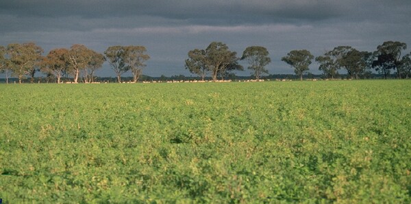 LP89 Landscape |
Soil Profile Morphology
Surface Soil
| A1 | 0-10 cm | Dark reddish brown (5YR3/3); fine sandy clay loam; hardsetting surface condition; moderate blocky structure; firm consistence dry; pH 5.8; sharp change to: | 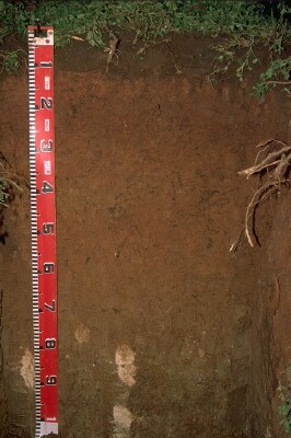 LP89 Profile |
| Subsoil | |||
| B1 | 10-20 cm | Yellowish red (5YR4/6); heavy clay loam (fine sandy); weak coarse blocky structure; very strong consistence dry; pH 7.4; clear change to: | |
| B21 | 20-35 cm | Yellowish red (5YR4/6); medium clay; moderate blocky structure (with smooth faced peds); strong consistence dry; pH 8.1; clear change to: | |
| B22 | 35-50 cm | Strong brown (7.5YR5/6) and yellowish red (5YR5/8); medium heavy clay; weakly structured; very strong consistence dry; pH 8.7; clear change to: | |
| B23 | 50-70 cm | Strong brown (7.5YR5/6); medium heavy clay; weakly structured; very strong consistence dry; pH 9.2; gradual change to: | |
| B24k | 70-100 cm | Yellowish brown (10YR5/6) with yellowish red (5YR5/8) in tubules; heavy clay; moderate coarse prismatic, parting to strong polyhedral structure; very strong consistence dry; contains a few (5%) soft and hard carbonates; pH 9.3. | |
Key Profile Features
- Strong texture contrast between surface (A1) horizon and subsoil (B1) horizon.
- Sodic subsoil.
Key Profile Characteristics
pH | Salinity Rating | |||
Surface (A1 horizon) | moderately acid | low | non-sodic | none1 |
Subsoil (B21 horizon) | moderately alkaline | low | sodic | strong |
Deeper subsoil (at 70+ cm) | very strongly alkaline | low-medium | strongly sodic | strong |
| 1 Slight slaking only. | ||||
 |
Horizon | Horizon Depth | pH (water) | pH CaCl2 | EC 1:5 | NaCl | Exchangeable Cations | |||
Ca | Mg | K | Na | ||||||
meq/100g | |||||||||
A1 | 0-10 | 5.8 | 5.2 | 0.19 | 7.3 | 0.7 | 0.7 | <0.1 | |
B1 | 10-20 | 7.4 | 6.3 | 0.13 | 5.8 | 4.3 | 0.9 | 9 | |
B21 | 20-35 | 8.1 | 6.9 | 0.19 | 7.8 | 8.5 | 1.4 | 12 | |
B22 | 35-50 | 8.7 | 7.6 | 0.29 | <0.05 | 7.8 | 11 | 1.8 | 18 |
B23 | 50-70 | .2 | 8.1 | 0.37 | <0.05 | 6.7 | 12 | 1.9 | 22 |
B24k | 70+ | 9.3 | 8.4 | 0.69 | <0.05 | 4.9 | 13 | 1.9 | 29 |
Horizon | Horizon Depth | Ex Al mg/kg | Ex Ac meq/100g | Field pF2.5 | Wilting Point pF4.2 | Coarse Sand (0.2-2.0mm) | Fine Sand (0.02-0.2mm) | Silt (0.002-0.02mm) | Clay (<0.002mm) |
A1 | 0-10 | 20.6 | 7.4 | 13 | 44 | 24 | 20 | ||
B1 | 10-20 | 22.4 | 12.7 | 10 | 34 | 15 | 41 | ||
B21 | 20-35 | 34.6 | 20 | 4 | 23 | 12 | 60 | ||
B22 | 35-50 | 40.1 | 23.3 | 4 | 16 | 11 | 68 | ||
B23 | 50-70 | 41.1 | 23 | ||||||
B24k | 70+ |
Management Considerations:
Whole Profile
- Plant Available Water Capacity (PAWC) is considered to be medium (estimated at approximately 120 mm) for this site. This is based on available laboratory data and assumes an effective rooting depth of 70 cm. Rooting depth will be limited by the strongly sodic deeper subsoil. However, lucerne roots were evident at 1 m depth in this profile.
Surface (A) Horizon
- Organic matter levels are relatively high. This is a good result as organic matter assists in maintaining soil structure as well as enhancing soil fertility and water holding capacity. This is important on soils such as this with high fine sand (44%) contents. High organic matter levels will assist in minimising structural problems, such as surface sealing (by reducing slaking) and hardsetting. This will lead to improved water infiltration and seedling emergence. Organic matter levels can be maintained and improved by practises such as minimal tillage, stubble retention and pasture rotations. Signs of reasonable topsoil structural condition at this site include the moderate structure and minimal slaking in water.
- The surface soil has a moderate overall nutrient status.
Subsoil (B) Horizons
- The upper subsoil (B1) horizon disperses slightly in water and strongly after remoulding. If this horizon is excessively disturbed by cultivation when moist, it may develop into a cultivation pan.
- The deeper subsoil (from a 35 cm depth) is strongly sodic and has a low calcium:magnesium ratio (i.e. <1). As a consequence, it disperses strongly in water. This is likely to result in water and root movement being significantly restricted.
- The deeper subsoil (from 50 cm depth) is very strongly alkaline which indicates that some nutrients (e.g. phosphorus, iron, manganese, and zinc) may be poorly available to plants.
- The salinity rating increases to between low and medium at 70 cm. However, chloride salts seem to be quite low and are not likely to restrict the growth of most plants.
Comments from Landholder:
- Cultivated once or twice in last seven years.
- Variable paddock (crabholes and black banks occur further east).
- Stubble retention.
- Wheat has yielded well.
Notes
- Profile described by Mark Imhof, Paul Rampant and Karen De Plater (5/7/95)