Victorian Resources Online (archived)
LP9
| Group: Middle Creek Landcare Group | Australian Soil Classification: Hypercalcic, Subnatric, Red SODOSOL |
| Northcote Factual Key:Dy 2.43 | Great Soil Group: solodized solonetz |
| General Landscape Description: Upper slope on western side of a sedimentary (lower Ordovician) hillslope. Yellow Gum (E. leucoxylon) and Grey Box (E. microcarpa) association is the typical native vegetation. | |
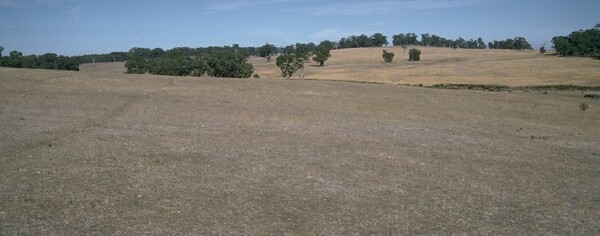 LP9 Landscape |
Soil Profile Morphology
Surface Soil
| A1 | 0-5 cm | Dark brown (10YR3/3) light fine sandy clay loam; weakly structured; firm consistence dry; contains occasional shale fragments; pH 5.5; sharp and irregular change to: | 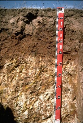 LP9 Profile |
| A2 | 5-10 cm | Light brown (7.5YR6/4) conspicuously bleached fine sandy clay loam; weakly structured; strong consistence dry; contains a slight (10%) amount of ferruginous nodules (buckshot); pH 6.5; sharp and irregular change to: | |
| Subsoil | |||
| B21 | 10-25 cm | Yellowish Red (5YR5/8) heavy clay; moderate coarse columnar, breaking down to strong coarse blocky structure (with smooth faced peds); very strong consistence moist; contains occasional shale fragments; pH 7.1; sharp and wavy change to: | |
| B22 | 25-40 cm | Red (2.5YR4/8) heavy clay; strong medium blocky structure; very strong consistence moist; contains occasional shale fragments; pH 8.6 : | |
| B3k | 40-100 cm | Strong brown (7.5YR4/6) medium clay; with a heavy (>50%) amount of soft carbonate together with weathered shale; pH 9.3; gradual change to: | |
| C | 100+ cm | Laminated soft shale. | |
Key Profile Features
- Strong textural contrast between A horizon and clay B horizons.
- Sodic subsoil.
- Increasing pH with depth down the profile.
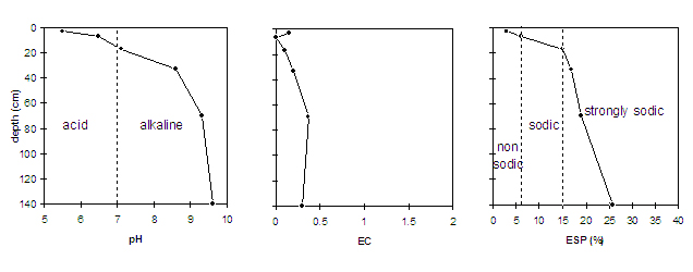
Key Profile Characteristics
pH | Salinity Rating | |||
Surface (A1 horizon) | strongly acid | very low | non-sodic | water-stable |
Subsoil (B21 horizon) | slightly alkaline | very low | sodic | strong |
Deeper subsoil (at 1 m) | very strongly alkaline | low | strongly sodic | strong |
 |
Management Considerations:
Surface (A) horizons
- The surface horizon has high levels of organic carbon and total nitrogen and a moderate overall nutrient status. However, being very shallow (i.e. 5 cm deep) it provides a limited rooting environment above the sodic subsoil.
- The high organic matter levels ensure that the surface aggregates are water-stable and will not readily break down when wet.
- Aluminium and manganese toxicity can occur in strongly acid surface soils, although exchangeable aluminium and manganese levels appear relatively low at this site. A lime test (sampled at the paddock level) may be appropriate to determine whether lime is needed to raise the pH levels.
- The conspicuously bleached A2 horizon indicates that periodic waterlogging may occur. This horizon has low fertility and is likely to become "soupy" when worked in a wet condition (as is evident by strong dispersion occurring after remoulding).
Subsoil (B) Horizons
- The coarsely structured and dense subsoil (i.e. B21 horizon) is sodic and becomes strongly sodic with increasing depth down the profile. Strong dispersion occurs as a result, creating conditions which will restrict water and plant root movement.
- Effective plant rooting depth is shallow due to the coarsely structured sodic subsoil being encountered at 10 cm depth. Plant available water capacity for the profile is also low as a consequence.
- At a depth of 40 cm the soil becomes strongly alkaline which may result in nutrients such as phosphorous, iron, manganese and zinc becoming poorly available to plants.