Victorian Resources Online (archived)
LP90
| Mapsheet: CHARLTON | Aust. Soil Class.: Vertic (and Calcic), Mesonatric, Red SODOSOL |
| Northcote Factual Key: Dr 2.13 | Great Soil Group:red-brown earth |
| General Landscape Description: Lower slope of a low rise (3% slope) on a gently undulating plain. Original vegetation included Grey Box (Eucalyptus microcarpa) and Yellow Gum (E. leucoxylon). | |
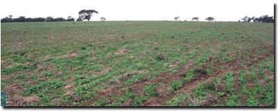 LP90 landscape |
Soil Profile Morphology
Surface Soil
| A1 | 0-10 cm | Dark reddish brown (5YR3/2); sandy clay loam; moderate coarse blocky structure; firm consistence moist; pH 6.7; abrupt change to: | 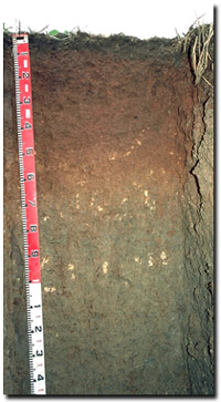 LP90 profile |
| Subsoil | |||
| B21 | 10-55 cm | Reddish brown (5YR4/4); medium heavy clay; strong coarse blocky, parting to strong medium blocky structure; some slickensides present towards bottom of horizon; pH 9.0; gradual change to: | |
| B22k | 55-70 cm | Yellowish red (5YR5/6); medium clay; strong coarse blocky structure; contains a few (2-5%) soft carbonates; pH 8.9: | |
| B31k | 70-100 cm | Pinkish grey (5YR6/2) and yellowish red (5YR5/8); medium clay; strong coarse prismatic, parting to moderate coarse blocky structure; contains a few (2-5%) soft carbonates and very few (2%) gypsum crystals at 70-80 cm depth; pockets of sand grains occur throughout on ped faces; pH 8.5: | |
| B32k | 100 cm+ | Grey (10YR6/1) and yellowish red (5YR5/8) (associated with root channels); medium clay; moderate coarse prismatic, parting to moderate fine to medium blocky structure; contains a few (2-5%) carbonate concretions; pH 8.7. | |
Key Profile Features
|
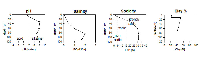
Key Profile Characteristics
pH | Salinity Rating | |||
Surface (A1 horizon) | slightly acid | very low | non-sodic | moderate 1 |
Subsoil (B21 horizon) | strongly alkaline | low | strongly sodic | strong |
Deeper subsoil (at 1 m) | strongly alkaline | very high | strongly sodic | - |
| 1complete dispersion with remoulding | ||||
 |
Horizon | Horizon Depth | pH (water) | pH CaCl2 | EC 1:5 | NaCl | Exchangeable Cations | |||
Ca | Mg | K | Na | ||||||
meq/100g | |||||||||
A1 | 0-10 | 6.7 | 5.8 | 009 | 8.1 | 3 | 0.7 | 0.2 | |
B21 | 10-55 | 9.0 | 7.9 | 0.33 | <0.05 | 11 | 11 | 1 | 6.4 |
B22k | 55-70 | 8.9 | 8.2 | 1.0 | 0.09 | 8.7 | 11 | 1.2 | 8.6 |
B31k | 70-100 | 8.5 | 8.2 | 2.0 | 0.16 | 8.3 | 11 | 1.3 | 9 |
B32k | 100+ | 8.7 | 8.3 | 1.7 | 0.24 | 7.2 | 11 | 1.2 | 8.6 |
Horizon | Horizon Depth | Ex Al mg/kg | Ex Ac meq/100g | Field pF2.5 | Wilting Point pF4.2 | Coarse Sand (0.2-2.0mm) | Fine Sand (0.02-0.2mm) | Silt (0.002-0.02mm) | Clay (<0.002mm) |
A1 | 0-10 | 18.9 | 9.8 | 26 | 38 | 10 | 23 | ||
B21 | 10-55 | 49.4 | 23.6 | 17 | 20 | 9 | 52 | ||
B22k | 55-70 | 42.8 | 22.3 | 15 | 21 | 9 | 45 | ||
B31k | 70-100 | 21 | 26 | 7 | 41 | ||||
B32k | 100+ |
Management Considerations:
Whole Profile
- Plant available water capacity (PAWC) is considered to be very low (estimated at 30 mm). This is based on available laboratory data and assumes an effective rooting depth of 20 mm. Effective rooting depth will be restricted by the strongly sodic subsoil and the increasing level of soluble salts with depth.
- The surface soil is non-sodic but disperses strongly after remoulding. This suggests that cultivation or overstocking of the soil whilst in a moist to wet condition may result in structural degradation (eg. exacerbated hardsetting, surface sealing, cloddiness) occurring. This will lead to restricted water infiltration and restrict seedling emergence. Raindrop impact on bare soil may also induce dispersion and result in surface sealing. Maintaining surface cover is important on such soils. Gypsum is likely to be an effective ameliorant.
- Organic matter is important for surface soils such as these (with high fine sand (38%) contents) in order to maintain soil aggregation. Practices such as residue retention, minimum tillage and including pasture rotations can be utilised to build up soil organic matter if cropping takes place.
- The coarsely structured upper subsoil is strongly sodic and disperses strongly. This will result in restricted root and water movement through the subsoil. Water is likely to build up on top of the subsoil after heavy rains as a result. Crops such as faba beans, chickpeas, lupins and canola have a low tolerance to waterlogging. The high levels of exchangeable magnesium may also compound the deleterious effects of exchangeable sodium on soil structure. The addition of gypsum with deep ripping has been advocated by some researchers as an ameliorative technique for sodic subsoils. A test strip could be used to assess likely benefits.
- The high levels of exchangeable sodium and magnesium in the subsoil may also result in nutrient imbalances and may even have a toxic effect on some plants.
- The level of soluble salts becomes medium by 55 cm depth. These levels may restrict the growth of salt sensitive species (eg. faba beans, chick peas, lupins). Soluble salt levels become high by 70 cm depth.
- The strongly alkaline subsoil indicates that some nutrients (eg. iron, manganese, copper, zinc) may be poorly available to plants. Plant tissue analysis can be performed to assess nutrient deficiencies.
- Originally a grazing paddock - been pasture for 40 years (til 1992).
- Pre-drilled fertiliser first year to provide seed bed.
- Rotation from 1992: faba beans; barley (24 bags/acre); chick peas (200 kg/ha); canola direct drilled (2 1/2 tonnes/ha); wheat.
- This site is part of a trial area with gypsum application (2.5 tonnes/hectare) applied .
- Continual 50 % yield increase since gypsum applied: compared to site LP91 where no gypsum has been applied.
Profile described by Mark Imhof, Paul Rampant and Karen De Plater (7/7/95)