Victorian Resources Online (archived)
LP91
| Mapsheet: CHARLTON | Aust. Soil Class.:Vertic (and Calcic), Mesonatric, Red SODOSOL |
| Northcote Factual Key: Dr 2.13 | Great Soil Group: red-brown earth |
| General Landscape Description: Lower slope on a low rise of a gently undulating plain. | |
Soil Profile Morphology
Surface Soil
| A1 | 0-12 cm | Dark brown (7.5YR3/4); sandy clay loam; moderate coarse blocky structure; firm consistence moist; pH 6.7; abrupt and wavy change to: | 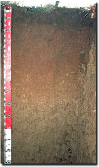 Lp91 profile |
| Subsoil | |||
| B21 | 12-45 cm | Yellowish red (5YR4/6); medium heavy clay; medium prismatic, breaking down to strong coarse to medium blocky structure (smooth faced peds); firm consistence moist; pH 8.9; gradual change to: | |
| B22k | 45-70 cm | Yellowish red (5YR5/6); medium heavy clay; moderate coarse blocky structure; firm consistence moist; contains a few (2-5%) soft carbonates and occasional nodules; some sand pockets present around ped faces; pH 8.7; gradual change to: | |
| B31k | 70-100 cm | Brown (7.5YR5/4) with Yellowish red (5YR4/6); medium heavy clay; moderate coarse blocky, breaking to strong fine blocky structure; firm consistence moist; contains very few (<2%) very fine gypsum crystals; many pockets of sand present along ped faces; pH 8.6; gradual change to: | |
| B32k | 100 cm+ | Light brown (7.5YR6/4) with Yellowish red (5YR5/8) (associated with sand pockets); medium heavy clay; strong coarse blocky, breaking to moderate medium blocky structure; slickensides present; contains numerous fine manganese flecks and pockets of sand between peds; pH 8.7. | |
Key Profile Features
|
Key Profile Characteristics
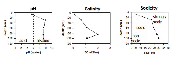
pH | Salinity Rating | |||
Surface (A1 horizon) | slightly acid | very low | non-sodic | strong |
Subsoil (B21 horizon) | strongly alkaline | low-medium | strongly sodic | moderate |
Deeper subsoil (at 1 m) | strongly alkaline | high | strongly sodic | - |
 |
Horizon | Horizon Depth | pH (water) | pH CaCl2 | EC 1:5 | NaCl | Exchangeable Cations | |||
Ca | Mg | K | Na | ||||||
meq/100g | |||||||||
A1 | 0-12 | 6.7 | 5.6 | 0.09 | 5.8 | 37 | 0.6 | 0.4 | |
B21 | 12-45 | 8.9 | 8.1 | 0.63 | 0.06 | 13 | 12 | 0.9 | 7.3 |
B22k | 45-70 | 8.7 | 8.1 | 1.11 | 0.15 | 9.5 | 11 | 1 | 6.8 |
B31k | 70-100 | 8.6 | 8.3 | 2 | 0.2 | 9.8 | 11 | 0.8 | 8.4 |
B32 | 100 | 8.7 | 8.1 | 1.12 | 0.15 | 7.2 | 9.3 | 0.7 | 7.1 |
Horizon | Horizon Depth | Ex Al mg/kg | Ex Ac meq/100g | Field pF2.5 | Wilting Point pF4.2 | Coarse Sand (0.2-2.0mm) | Fine Sand (0.02-0.2mm) | Silt (0.002-0.02mm) | Clay (<0.002mm) |
A1 | 0-12 | 18 | 8.1 | ||||||
B21 | 12-45 | 44.9 | 24.5 | ||||||
B22k | 45-70 | 46.7 | 26.8 | ||||||
B31k | 70-100 | ||||||||
B32 | 100 |
Comments from Landholder:
- This site is part of a trial area without gypsum application.
- Originally a grazing paddock. Under pasture for 40 years (til 1992).
- Rotation from 1992: faba beans; barley (17 bags/acre); chick peas (140 kg/ha).
Profile described by Mark Imhof, Paul Rampant and Karen De Plater (7/7/95)