Victorian Resources Online (archived)
LP97
| Group: Mount Camel Landcare Group | Australian Soil Classification: Vertic (and Calcic), Mottled-Mesonatric, Brown SODOSOL |
| Northcote Factual Key: Dy 3.43 | Great Soil Group: red-brown earth |
| General Landscape Description: Lower slope (5%) on an undulating low hill (Cambrian to lower Ordovician sediments). | |
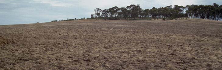 LP97 Landscape |
Soil Profile Morphology
Surface Soil
| A1 | 0-10 cm | Dark reddish brown (5YR3/3); sandy clay loam; hardsetting surface condition; weak coarse blocky structure; very firm consistence dry; contains a common (15%) amount of ironstone, quartz and jasper gravel (5 mm average size); pH 6; abrupt change to; | 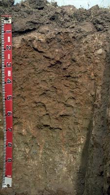 LP97 profile |
| A2 | 10-15 cm | Yellowish red (5YR5/6) conspicuously bleached (5YR7/3); sandy clay loam; discontinuous along soil pit; massive; strong consistence dry; contains many (25%) angular quartz, jasper and ironstone gravels (5 mm average size); pH 6.8; sharp change to; | |
| Subsoil | |||
| B21 | 15-50 cm | Yellowish brown (10YR5/6) with strong brown (7.5YR5/6) mottles; medium heavy clay; moderate coarse blocky structure; very firm consistence moderately moist; contains a few (5%) gravels (average size 8 mm); small slickensides present; pH 7.9; gradual change to; | |
| B22 | 50-80 cm | Strong brown (7.5YR5/6); medium clay; weak to moderate coarse blocky structure; very strong consistence dry; pH 8.7; clear change to; | |
| B31k | 80-110 cm | Light brownish grey (2.5Y6/2) with light olive brown (2.5Y5/4), yellowish red (5YR5/8) and brownish yellow (10YR6/6) mottles; medium heavy clay; moderate medium polyhedral, parting to moderate fine polyhedral structure; contains a few (5%) fine-earth carbonates in patches and a common (10-20%) amount of angular quartz (4 mm), ironstone (4 cm) and mudstone (10-20 mm) gravel; pH 9.0. | |
Key Profile Features
- Strong texture contrast between surface (A) horizons (<17% clay) and subsoil (B21) horizon (48% clay).
- Coarsely structured, strongly sodic subsoil.
- Deeper subsoil displays vertic properties and contains free carbonate (lime).
Key Profile Characteristics
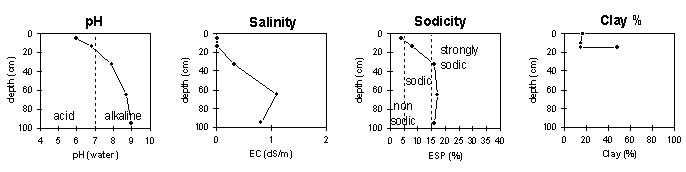
pH | Salinity Rating | |||
Surface (A1 horizon) | moderately acid | very low | non-sodic | none1 |
Subsoil (25-45 horizon) | slightly alkaline | low | strongly sodic | strong |
Deeper subsoil (1 m) | strongly alkaline | medium | strongly sodic | none2 |
| 1 slight dispersion with remoulding 2 possibly due to medium level of soluble salts. | ||||
 |
Horizon | Horizon Depth | pH (water) | pH CaCl2 | EC 1:5 | NaCl | Exchangeable Cations | |||
Ca | Mg | K | Na | ||||||
meq/100g | |||||||||
A1 | 0-10 | 6 | 5 | <0.05 | 4 | 2.1 | 0.5 | 0.3 | |
A2 | 10-15 | 6.8 | 5.6 | <0.05 | 2.4 | 2.3 | 0.2 | 0.4 | |
B21 | 15-50 | 7.9 | 6.8 | 0.33 | <0.05 | 5.2 | 14 | 0.7 | 3.8 |
B22 | 50-80 | 8.7 | 8.2 | 1.0 | 0.18 | 7 | 19 | 0.7 | 7.4 |
B31k | 80-110 | 9 | 8.4 | 0.81 | 0.09 | 14 | 17 | 0.7 | 6 |
Horizon | Horizon Depth | Ex Al mg/kg | Ex Ac meq/100g | Field pF2.5 | Wilting Point pF4.2 | Coarse Sand (0.2-2.0mm) | Fine Sand (0.02-0.2mm) | Silt (0.002-0.02mm) | Clay (<0.002mm) |
A1 | 0-5 | 18.9 | 6.2 | 18 | 48 | 15 | 17 | ||
A2 | 5-25 | 12.7 | 4.6 | 23 | 49 | 15 | 15 | ||
B21 | 25-45 | 31.6 | 17.2 | 14 | 27 | 11 | 48 | ||
B22 | 45-55 | ||||||||
C | 55 |
Management Considerations:
In general, management strategies for all soils should aim to increase organic matter levels in the surface soil; minimise the degradation of soil aggregates and porosity; promote the development of stable biopores; improve the calcium status of the ion exchange complex (particularly when sodium is a significant part – i.e. sodic), and break up any hardpans. Less frequent tillage; using less aggressive implements, and working the soil at optimum moisture conditions can all assist in maintaining soil aggregation and porosity as well as reducing the breakdown of organic matter. Practices such as residue retention, minimum tillage and including pasture rotations could be utilised if cropping takes place in order to build up organic matter, reduce erosion risk and increase fertility.
Plant available water capacity (PAWC) is considered to be low (estimated at 70 mm). This is based on available laboratory data an assumes an effective rooting depth of 40 cm. Rooting depth will be limited by the strongly sodic and dispersive upper subsoil.
Notes:
- Profile described by Mark Imhof, Paul Rampant and Karen De Plater (29/11/95.)