Victorian Resources Online (archived)
LP98
| Group: Mount Camel Landcare Group | Australian Soil Classification: Vertic, Subnatric, Red SODOSOL |
| Northcote Factual Key: Dr 2.23 | Great Soil Group: red-brown earth |
| General Landscape Description: Closed depression on plain beneath Mt. Camel Range. Gilgai microrelief present. Original vegetation included Grey Box (Eucalyptus microcarpa). This soil will have formed on alluvial and colluvial deposits (originating from higher areas). | |
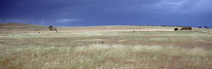 LP98 Landscape |
Soil Profile Morphology - LP98a
Surface Soil
| A11 | 0-7 cm | Dark yellowish brown (5YR3/4); fine sandy clay loam; weak medium blocky structure; strong consistence dry; contains few (5%) ferruginous and angular quartz gravel; pH 6.1; abrupt change to: | 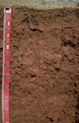 LP98 Profile a |
| A21 | 7-13 cm | Dark yellowish brown (5YR4/4); clay loam (fine sandy); moderate coarse blocky structure; strong consistence dry; contains few (5%) ferruginous gravels (average size 4 mm); pH 6.2: | |
| A22 | 13-20 cm | Dark yellowish brown (5YR4/6); clay loam (fine sandy); weak coarse blocky structure; strong consistence dry; contains a few (5%) gravels (average size 4 mm); pH 6.5; abrupt change to: | |
| Subsoil | |||
| B21 | 20-50 cm | Dark red (2.5YR3/6); medium heavy clay; moderate coarse blocky structure; significant cracking evident when dry; very strong consistence dry; pH 6.8; gradual change to: | |
| B22 | 50-80 cm | Red (2.5YR5/8); medium heavy clay; moderate coarse blocky structure; numerous slickensides; very strong consistence dry; pH 8.5; gradual change to: | |
| B31k | 80 cm+ | Dark red (2.5YR4/7); medium heavy clay; moderate coarse blocky structure; slickensides; firm consistence moist; pH 8.9. | |
Soil Profile Morphology - LP98b
NOTE: The surface horizon varies in depth and gravel content. These variations are associated with the gilgai microrelief due to the vertic properties of the subsoil.
Surface Soil
| A1 | 0-8 cm | Dark reddish brown (5YR3/4); fine sandy clay loam; contains a common (10%) amount of ferruginous gravel; pH 6.1; abrupt change to: | 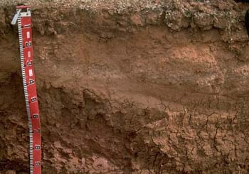 LP98 profile b |
| A21 | 8-16 cm | Reddish brown (2.5YR4/4); clay loam (fine sandy); contains a common (10%) amount of ferruginous gravel (5 mm average size); pH 6.3; sharp change to: | |
| A22 | 16-30 cm | Dark yellowish brown (5YR4/6); clay loam (fine sandy); weak coarse blocky structure; strong consistence dry; contains a few (5%) gravels (average size 4 mm); pH 6.5; abrupt change to: | |
| A23 | 30-45 cm | Yellowish red (5YR5/6), conspicuously bleached (5YR7/4d); clay loam (fine sandy); contains very many (45%) gravels (2-4 mm size range); pH 7; sharp and irregular change to: | |
| Subsoil | |||
| B21 | 45 cm + | Red (2.5YR4/8) with strong brown (7.5YR5/6) mottles; medium clay; moderate coarse prismatic, parting to moderate coarse blocky structure; pH 7.3. | |
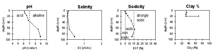
Key Profile Features
- Strong texture contrast between surface (A) horizons (<34% clay) and subsoil (B21) horizon (69% clay).
- Coarsely structured, sodic subsoil.
- Deeper subsoil has vertic properties (slickensides present).
- Variability in soil due to gilgai microrelief.
pH | Salinity Rating | |||
Surface (A1 horizon) | slightly acid | very low | non-sodic | none1 |
Subsoil (25-45 horizon) | slightly acid | very low | sodic | none2 |
Deeper subsoil ( 80 cm+) | strongly alkaline | low | sodic | complete |
| 1 slight dispersion with remoulding 2 complete dispersion with remoulding | ||||
 |
LP98a
Horizon | Horizon Depth | pH (water) | pH CaCl2 | EC 1:5 | NaCl | Exchangeable Cations | |||
Ca | Mg | K | Na | ||||||
meq/100g | |||||||||
A11 | 0-7 | 6.1 | 5.1 | 0.07 | 7 | 4.5 | 0.8 | 0.6 | |
A21 | 7-13 | 6.2 | 4.9 | 0.05 | 5.6 | 4.1 | 0.5 | 0.6 | |
A22 | 13-20 | 6.5 | 5 | <0.05 | 3.8 | 3.4 | 0.3 | 0.6 | |
B21 | 20-50 | 6.8 | 5.3 | 0.05 | 6 | 9.3 | 0.5 | 2 | |
B22 | 50-80 | 8.5 | 7 | 0.13 | 7.5 | 21 | 0.7 | 5.2 | |
B23 | 80+ | 8.9 | 8 | 0.42 | <0.05 | 17 | 19 | 0.6 | 5.5 |
Horizon | Horizon Depth | Ex Al mg/kg | Ex Ac meq/100g | Field pF2.5 | Wilting Point pF4.2 | Coarse Sand (0.2-2.0mm) | Fine Sand (0.02-0.2mm) | Silt (0.002-0.02mm) | Clay (<0.002mm) |
A11 | 0-7 | 31.7 | 14.6 | 9.8 | 30.9 | 22.5 | 31.5 | ||
A21 | 7-13 | 25.4 | 12.7 | 9.2 | 32 | 25.5 | 33.5 | ||
A22 | 13-20 | 22.8 | 11.2 | 10.3 | 34.6 | 24 | 32 | ||
B21 | 20-50 | 37.8 | 22.3 | 5.1 | 15.6 | 11.5 | 68.5 | ||
B22 | 50-80 | 47.6 | 25.8 | ||||||
B23 | 80+ |
LP98b
Horizon | Horizon Depth | pH (water) | pH CaCl2 | EC dS/m | NaCl | Exchangeable Cations | |||
Ca | Mg | K | Na | ||||||
Meq/100g | |||||||||
A21 | 8-16 | 6.3 | 5.1 | <0.05 | 6.6 | 4.6 | 0.5 | 0.5 | |
A22 | 16-30 | 6.6 | 5.2 | <0.05 | 3.5 | 3.1 | 0.4 | 0.3 | |
A23 | 30-45 | 7 | 5.4 | <0.05 | 2.1 | 2.9 | 0.7 | 0.2 | |
B21 | 45+ | 7.3 | 5.9 | <0.05 | 3.9 | 8.7 | 2.7 | 0.4 | |
Horizon | Horizon Depth | Ex Al mg/kg | Ex Ac meq/100g | Field pF2.5 | Wilting Point pF4.2 | Coarse Sand (0.2-2.0mm) | Fine Sand (0.02-0.2mm) | Silt (0.002-0.02mm) | Clay (<0.002mm) |
A21 | 8-16 | 25.8 | 13.1 | 9.7 | 30.7 | 24.5 | 33.5 | ||
A22 | 16-30 | 21.9 | 10.1 | ||||||
A23 | 30-45 | 20.1 | 9.1 | 13.4 | 35.8 | 26 | 26 | ||
B21 | 45+ | 31.6 | 19.5 | 7 | 20.1 | 15.5 | 61 |
Management Considerations:
- In general, management strategies for all soils should aim to increase organic matter levels in the surface soil; minimise the degradation of soil aggregates and porosity; promote the development of stable biopores; improve the calcium status of the ion exchange complex (particularly when sodium is a significant part – i.e. sodic), and break up any hardpans. Less frequent tillage; using less aggressive implements, and working the soil at optimum moisture conditions can all assist in maintaining soil aggregation and porosity as well as reducing the breakdown of organic matter. Practices such as residue retention, minimum tillage and including pasture rotations could be utilised if cropping takes place in order to build up organic matter, reduce erosion risk and increase fertility.
- Plant available water capacity (PAWC) is considered to be medium (estimated at approximately 150 mm) in the areas with shallower surface horizons (i.e. profile 98a). This is based on available laboratory data and assumes an effective rooting depth of 90 cm. In areas with the deeper and gravelly surface horizons (i.e. profile 98b) plant available water capacity will be significantly reduced and is considered to be low (estimated at 60 mm). An effective rooting depth of 50 cm is assumed. Rooting depth will be restricted by the high gravel content of the lower surface horizons.
Surface (A) Horizons
- The surface soil disperses moderately after remoulding. This indicates that cultivation or overstocking of the soil in a moist to wet condition may result in structural degradation (eg. surface sealing, exacerbated hardsetting) occurring. Raindrop impact on bare soil is also likely to cause structural degradation so it is important to maintain surface cover. Structural degradation will result in problems such as decreased water infiltration, friability and seedling emergence.
- The lower A horizon (i.e. 13-20 cm layer) of profile LP98a is sodic and disperses completely after remoulding. Tillage of this layer when moist to wet may result in the development of a plough pan.
- High gravel contents in some areas will result in restricted root penetration.
Subsoil (B) Horizons
- The subsoil is sodic (and has a high level of exchangeable magnesium relative to calcium) which indicates that root and water movement will be restricted somewhat by the coarsely structured subsoil. Dispersion does not occur in the upper subsoil - suggesting that permeability will be better than for Site 98.
- The subsoil displays evidence of vertic properties (i.e. significant cracking, presence of numerous slickensides) which indicates that significant shrinking and swelling occurs in wetting and drying cycles. This will cause subsoil movement and has resulted in the gilgai (‘crabholey’) microrelief at the surface. Variations in subsurface horizons has occurred as a result. These vertic properties may have implications for engineering purposes (e.g. building foundations).
- Has been under pasture for 3 years. Lupins and wheat were grown prior.
- Considered a good cropping soil but can become boggy in winter.
- Superphosphate and gypsum never applied.
- Profile described by Mark Imhof, Paul Rampant and Karen DePlater (28/11/95)