Victorian Resources Online (archived)
LP99
| Group: Mount Camel Landcare Group | Australian Soil Classification: Haplic, Eutrophic, Red FERROSOL |
| Northcote Factual Key: Gn 4.12 | General Landscape Description: Saddle on crest of Mt. Camel Range. This soil has developed on Cambrian greenstone. |
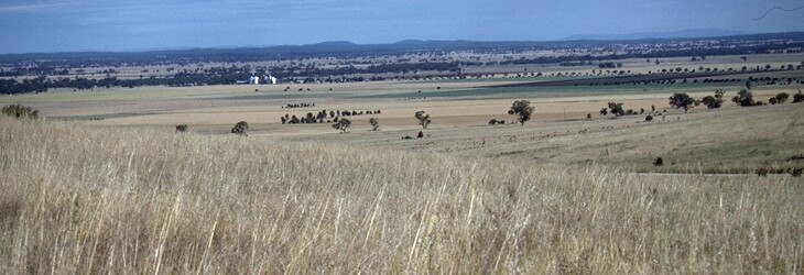 LP99 Landscape |
Soil Profile Morphology
Surface Soil
| A1 | 0-7 cm | Dark red (2.5YR3/6); fine sandy clay loam; moderate medium blocky structure; very firm consistence dry; significant biological activity evident (i.e. spiders, termites); pH 5.6: | 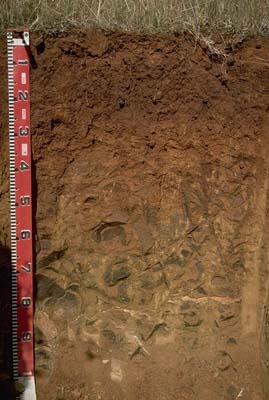 LP99 profile |
| Subsoil | |||
| B21 | 7-20 cm | Dark red (2.5YR3/6); light medium clay; moderate coarse blocky, parting to strong medium to fine blocky structure; strong consistence dry; contains a few (2-10%) angular quartz (<2 cm size) and hard greenstone fragments (average size 3 cm); pH 6.0: | |
| B22 | 20-35 cm | Dark red (2.5YR3/6); light clay; moderate coarse blocky structure; very firm consistence dry; pH 6.6: | |
| B23 | 35-60 cm | Dark red (2.5YR4/8) and strong brown (7.5YR5/6); light sandy clay loam; very firm consistence dry; pH 6.9: | |
| C | 60-100 cm+ | Weathered greenstone base rock; pH 7.9. | |
Key Profile Features
- Gradual changes in clay content with depth.
Key Profile Characteristics
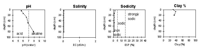
pH | Salinity Rating | |||
Surface (A1 horizon) | moderately acid | very low | non-sodic | none |
Subsoil (25-45 horizon) | moderately acid | very low | non-sodic | none |
Deeper subsoil ( 60 cm) | slightly alkaline | very low | non-sodic | none |
 |
Horizon | Horizon Depth | pH (water) | pH CaCl2 | EC 1:5 | NaCl | Exchangeable Cations | |||
Ca | Mg | K | Na | ||||||
meq/100g | |||||||||
A1 | 0-7 | 5.6 | 4.7 | <0.05 | 12 | 5 | 0.2 | 0.4 | |
B21 | 7-20 | 6 | 5 | <0.05 | 19 | 7.3 | 0.2 | 0.2 | |
B22 | 20-35 | 6.6 | 5.7 | <0.05 | 36 | 16 | 0.2 | 0.2 | |
B23 | 35-60 | 6.9 | 6 | <0.05 | 39 | 19 | 0.1 | 0.3 | |
C | 60-100 | 7.9 | 6.6 | <0.05 | 32 | 18 | 0.1 | 0.4 | |
Horizon | Horizon Depth | Ex Al mg/kg | Ex Ac meq/100g | Field pF2.5 | Wilting Point pF4.2 | Coarse Sand (0.2-2.0mm) | Fine Sand (0.02-0.2mm) | Silt (0.002-0.02mm) | Clay (<0.002mm) |
A1 | 0-7 | 33.6 | 14.7 | 5.8 | 34.4 | 25 | 29.5 | ||
B21 | 7-20 | 29.8 | 16.2 | 6.5 | 31.7 | 20.5 | 37.5 | ||
B22 | 20-35 | 34.1 | 19.8 | 8.7 | 30.9 | 19.5 | 33 | ||
B23 | 35-60 | 26 | 14.7 | ||||||
C | 60-100 |
Management Considerations:
Whole Profile
- In general, management strategies for all soils should aim to increase organic matter levels in the surface soil; minimise the degradation of soil aggregates and porosity; promote the development of stable biopores; improve the calcium status of the ion exchange complex (particularly when sodium is a significant part – i.e. sodic), and break up any hardpans. Less frequent tillage; using less aggressive implements, and working the soil at optimum moisture conditions can all assist in maintaining soil aggregation and porosity as well as reducing the breakdown of organic matter. Practices such as residue retention, minimum tillage and including pasture rotations could be utilised if cropping takes place in order to build up organic matter, reduce erosion risk and increase fertility.
- Plant available water capacity (PAWC) is considered to be moderate (estimated at 90 mm). This is based on available laboratory data and assumes an effective rooting depth of 70 cm. Rooting depth will be restricted by the weathering base rock.
- The surface soil is reasonably well structured and has relatively high levels of organic matter and nitrogen. Organic matter is important for maintaining aggregation of surface soils. Surface aggregates at this site are water-stable and do not slake in water.
- The nutrient status (based on the sum of the exchangeable basic cations) is moderate.
- The upper subsoil is well structured and non-sodic. This would suggest that these soils are well drained and will provide a good rooting environment for plants.
- Profile described by Mark Imhof, Paul Rampant and Karen DePlater (28/11/95)