Victorian Resources Online (archived)
Archived content — This page contains material from the Victorian Resources Online (VRO) website. It is no longer maintained and is provided for reference only. This content is hosted by CeRDI and is not endorsed by Agriculture Victoria.
Sitemap
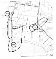
114. Bass Highway - Old Sea Cliff
|
This information has been developed from one or more of these publications:
- Sites of Geological and Geomorphological Significance in the Westernport Bay Catchment (1984) by Neville Rosengren.
- Sites of Geological and Geomorphological Significance in the Western Region of Melbourne (1986) by Neville Rosengren
- Sites of Geological and Geomorphological Significance on the Coast of Port Phillip Bay (1988) by Neville Rosengren.
- Sites of Environmental Significance in the Flood Plain of the Upper Yarra Valley Region (1983) by Neville Rosengren, Douglas Frood and Kim Lowe (as part of a study of Sites of Environmental Significance by the University of Melbourne for the then Upper Yarra Valley and Dandenong Ranges Authority).
Geological heritage sites, including sites of geomorphological interest and volcanic heritage sites, are under regular revision by the Geological Society of Australia, especially in the assessment of significance and values. Reference should be made to the most recent reports. See the Earth Science Heritage section of the Geological Society of Australia website (external link) for details of geological heritage reports, and a bibliography. |
| Location: | Lang Lang - 723573. Six kilometres south of Lang Lang. |
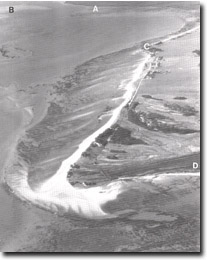 The multiple recurving spits that comprise Stockyard point. Also shown are Lang Lang delta (A), tidal watershed (B), Red bluff (C), part of Pioneer Bay (D). The multiple recurving spits that comprise Stockyard point. Also shown are Lang Lang delta (A), tidal watershed (B), Red bluff (C), part of Pioneer Bay (D). |
Access: |
Bass Highway. |
Ownership: |
Mainly private land and some Crown Land. |
Geology/Geomorphology: |
The ridge of Baxter Formation sediments that extends east from Red Bluff has a distinct erosion escarpment on the southern side 15 metres high. The escarpment is crossed by the Bass Highway. The escarpment is a former marine cliff developed prior to the accumulation of Stockyard point and the sedimentary fill in Pioneer Bay. It represents an interglacial sea level several metres above that of the present. |
Significance: |
Regional. The site illustrates a relief form developed at different sea levels from the present and is one of several such localities around Westernport Bay. |
Management: |
Class 3. Changes in land use are not likely to alter the significance of the feature. |