Victorian Resources Online (archived)
Archived content — This page contains material from the Victorian Resources Online (VRO) website. It is no longer maintained and is provided for reference only. This content is hosted by CeRDI and is not endorsed by Agriculture Victoria.
Sitemap
120. Poowong - Valley Capture
|
This information has been developed from one or more of these publications:
- Sites of Geological and Geomorphological Significance in the Westernport Bay Catchment (1984) by Neville Rosengren.
- Sites of Geological and Geomorphological Significance in the Western Region of Melbourne (1986) by Neville Rosengren
- Sites of Geological and Geomorphological Significance on the Coast of Port Phillip Bay (1988) by Neville Rosengren.
- Sites of Environmental Significance in the Flood Plain of the Upper Yarra Valley Region (1983) by Neville Rosengren, Douglas Frood and Kim Lowe (as part of a study of Sites of Environmental Significance by the University of Melbourne for the then Upper Yarra Valley and Dandenong Ranges Authority).
Geological heritage sites, including sites of geomorphological interest and volcanic heritage sites, are under regular revision by the Geological Society of Australia, especially in the assessment of significance and values. Reference should be made to the most recent reports. See the Earth Science Heritage section of the Geological Society of Australia website (external link) for details of geological heritage reports, and a bibliography. |
Location: |
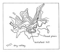
Nyora - 895535. Three kilometres north-east of Loch. |
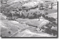 Isolated hill (A), dry valley (arrow), Bass River floodplain (B). Isolated hill (A), dry valley (arrow), Bass River floodplain (B). |
Access: |
Loch - Poowong road. |
Ownership: |
Crown Land (Public Land Water Frontage Reserve) and private land. |
Geology/Geomorphology: |
A small spur of Mesozoic sandstone deflects the Bass River and the spur end is now an isolated hill. The isolation is due to capture by the river of the lower valley of a tributary creek that originally entered the Bass River 500 metres to the west. The Poowong to Loch road traverses this abandoned valley north of the isolated hill. |
Significance: |
Regional. The site illustrates a mechanism of the isolation of bedrock inliers in younger flood plain sediments. This is an exceptionally clear example of a stage in this process. |
Management: |
Class 3. Changes in land use will be unlikely to alter the significance of the features at the site. |