Victorian Resources Online (archived)
Archived content — This page contains material from the Victorian Resources Online (VRO) website. It is no longer maintained and is provided for reference only. This content is hosted by CeRDI and is not endorsed by Agriculture Victoria.
Sitemap
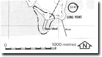
214. Rams Island - Tombolo
|
This information has been developed from one or more of these publications:
- Sites of Geological and Geomorphological Significance in the Westernport Bay Catchment (1984) by Neville Rosengren.
- Sites of Geological and Geomorphological Significance in the Western Region of Melbourne (1986) by Neville Rosengren
- Sites of Geological and Geomorphological Significance on the Coast of Port Phillip Bay (1988) by Neville Rosengren.
- Sites of Environmental Significance in the Flood Plain of the Upper Yarra Valley Region (1983) by Neville Rosengren, Douglas Frood and Kim Lowe (as part of a study of Sites of Environmental Significance by the University of Melbourne for the then Upper Yarra Valley and Dandenong Ranges Authority).
Geological heritage sites, including sites of geomorphological interest and volcanic heritage sites, are under regular revision by the Geological Society of Australia, especially in the assessment of significance and values. Reference should be made to the most recent reports. See the Earth Science Heritage section of the Geological Society of Australia website (external link) for details of geological heritage reports, and a bibliography. |
| Location: | Rhyll - 557459. 6 km east of Tortoise Head. | |
Access: |
Walk from Long Point Road. |
Ownership: |
Crown land. |
Geology/Geomorphology: |
Rams Island is a small basalt knob surrounded by gravel beaches. A gravel ridge or swashway about 200 m long connects the island to French Island. |
Significance: |
Local. The island is a very good example of a small tombolo. |
Management: |
Class 1. No removal of gravel or sand from the site should be permitted. No artificial coastal structures should be built in the area of the site. |