Victorian Resources Online (archived)
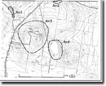
An1 - Anakie - Unconformity
|
This information has been developed from this publication:
|
| Location: | Anakie - 585046. Shire of Corio. Road cutting on Geelong-Ballan Road, 1 km northwest of Anakie Junction. | |
Access: | Geelong-Ballan Road. | |
Ownership: | Crown land. | |
Site Description: | The road cutting reveals the contact between steeply dipping Ordovician shales and sandstones, and iron-stained sands of the Moorabool Viaduct Formation. The plane of the unconformity is irregular, with gravels at the base of the Moorabool Viaduct Formation filling a former gully of the now buried land surface cut into the top of the Ordovician rocks. | |
Significance: | Local. The cutting is a clear exposure of an unconformity and shows the nature of the contact between Ordovician rocks and the overlying sediments in the Brisbane Ranges area. It is one of the best displays of this contact readily accessible in the Brisbane Ranges. | |
Management: | Class 2. Any road widening should be designed to maintain the clarity of the outcrop of the unconformity. | |
References: | Bolger PF (1980) | |