Victorian Resources Online (archived)
Archived content — This page contains material from the Victorian Resources Online (VRO) website. It is no longer maintained and is provided for reference only. This content is hosted by CeRDI and is not endorsed by Agriculture Victoria.
Sitemap
57. Balnarring Beach - Merricks Creek Barrier
|
This information has been developed from one or more of these publications:
- Sites of Geological and Geomorphological Significance in the Westernport Bay Catchment (1984) by Neville Rosengren.
- Sites of Geological and Geomorphological Significance in the Western Region of Melbourne (1986) by Neville Rosengren
- Sites of Geological and Geomorphological Significance on the Coast of Port Phillip Bay (1988) by Neville Rosengren.
- Sites of Environmental Significance in the Flood Plain of the Upper Yarra Valley Region (1983) by Neville Rosengren, Douglas Frood and Kim Lowe (as part of a study of Sites of Environmental Significance by the University of Melbourne for the then Upper Yarra Valley and Dandenong Ranges Authority).
Geological heritage sites, including sites of geomorphological interest and volcanic heritage sites, are under regular revision by the Geological Society of Australia, especially in the assessment of significance and values.Reference should be made to the most recent reports. See the Earth Science Heritage section of the Geological Society of Australia website (external link) for details of geological heritage reports, and a bibliography. |
| Location: | Somers – 358490 to 383489. Coastal area between Balnarring Beach Road and Lord Somers Road. | 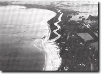 Mouth of Merricks Creek deflected by sand barriers, Site 57 Mouth of Merricks Creek deflected by sand barriers, Site 57 |
| Access: | Balnarring Beach Road and Lord Somers Road. |
| Ownership: | Crown Land and private land. |
| Geomorphology: | East of Balnarring Beach, Merricks Creek is deflected eastward for two kilometers by a narrow vegetated sand barrier. The river mouth is sand encumbered and outflow is restricted and frequently blocked by sand accumulation. An older barrier system lies parallel to the outermost barrier. The inner margin of coastal deposits is marked by a coastal bluff. |
| Significance: | Regional. This is one of the few sand barrier systems developed at stream mouths in Western Port and is a clear example of a multiple barrier system. |
| Management: | Class 2. Building construction and other major disturbances such as quarrying or dumping of any materials in the area should not be permitted. Other disturbances of the sandy terrain should be kept to a minimum. |