Victorian Resources Online (archived)
Archived content — This page contains material from the Victorian Resources Online (VRO) website. It is no longer maintained and is provided for reference only. This content is hosted by CeRDI and is not endorsed by Agriculture Victoria.
Sitemap
G28 - Cement Creek Junction - Old River Channel
|
This information has been developed from the publications:
- Sites of Geological and Geomorphological Significance in the Western Region of Melbourne (1986) by Neville Rosengren
- Sites of Geological and Geomorphological Significance on the Coast of Port Phillip Bay (1988) by Neville Rosengren.
- Sites of Geological and Geomorphological Significance in the Shire of Otway (1984) by Neville Rosengren.
Geological heritage sites, including sites of geomorphological interest and volcanic heritage sites, are under regular revision by the Geological Society of Australia, especially in the assessment of significance and values. Reference should be made to the most recent reports. See the Earth Science Heritage (external link) section of the Geological Society of Australia website for details of geological heritage reports, and a bibliography. |
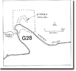
| Location: | AMG Ref: 906247. |  Swamp-filled former channel of Yarra River at Site G28. Swamp-filled former channel of Yarra River at Site G28. |
Access: |
From Riverside Road off Warburton - Woods Point Road. |
Geomorphology: |
A well defined swamp-filled former channel of the Yarra River occurs upstream from the junction of Cement Creek. |
Significance: |
Local. The site is of importance to demonstrate drainage processes in a little modified abandoned meander. |
Management: |
Class 1. To maintain the significance of the site, it will be necessary to prohibit any form of artificial drainage of the area. |
 Cement Creek Junction - Old River Channel