Victorian Resources Online (archived)
Archived content — This page contains material from the Victorian Resources Online (VRO) website. It is no longer maintained and is provided for reference only. This content is hosted by CeRDI and is not endorsed by Agriculture Victoria.
Sitemap
G35 - McMahons Creek - Alluvial/Colluvial Slopes and Terrace
|
This information has been developed from the publications:
- Sites of Geological and Geomorphological Significance in the Western Region of Melbourne (1986) by Neville Rosengren
- Sites of Geological and Geomorphological Significance on the Coast of Port Phillip Bay (1988) by Neville Rosengren.
- Sites of Geological and Geomorphological Significance in the Shire of Otway (1984) by Neville Rosengren.
Geological heritage sites, including sites of geomorphological interest and volcanic heritage sites, are under regular revision by the Geological Society of Australia, especially in the assessment of significance and values. Reference should be made to the most recent reports. See the Earth Science Heritage (external link) section of the Geological Society of Australia website for details of geological heritage reports, and a bibliography. |
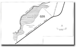
| Location: | AMG Ref: 975276. |  Alluvial and colluvial fans (A) and alluvial
terrace (B) at Site G35 Alluvial and colluvial fans (A) and alluvial
terrace (B) at Site G35 |
Access: |
From Woods Point - Warburton Road. |
Geomorphology: |
The slopes below the road are composite in origin and include alluvial fan and colluvial materials. At the slope foot, these grade into floodplain alluvium which forms the low swamp terrace adjacent to the river. |
Significance: |
Local. This slope sequence occurs at several localities on the valley between Warburton and the Woods Point turn-off. This site illustrates the sequence particularly well. |
Management: |
Class 3. No special management action is necessary to maintain the significance of the site. |
 McMahons Creek