Victorian Resources Online (archived)
Archived content — This page contains material from the Victorian Resources Online (VRO) website. It is no longer maintained and is provided for reference only. This content is hosted by CeRDI and is not endorsed by Agriculture Victoria.
Sitemap
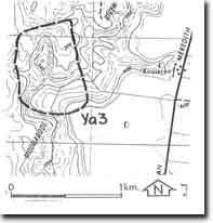
Ya3 - Moorabool River - Ingrown Meander
|
This information has been developed from this publication:
- Sites of Geological and Geomorphological Significance in the Western Region of Melbourne (1986) by Neville Rosengren
Geological heritage sites, including sites of geomorphological interest and volcanic heritage sites, are under regular revision by the Geological Society of Australia, especially in the assessment of significance and values. Reference should be made to the most recent reports. See the Earth Science Heritage section of the Geological Society of Australia website for details of geological heritage reports, and a bibliography. |
| Location: | Yaloak - 208485. Shire of Ballan. Moorabool River, 1.5 km west of ‘Koonlaroo’ homestead. | |
Access: |
Ballan-Meredith Road. |
Ownership: |
Crown land. |
Site Description: |
An angular, elongated, incised, ingrown meander, with a very narrow meander neck, has developed on the Moorabool River at this locality. |
Significance: |
Local. The meander is an unusual form of the Moorabool River and illustrates one stage in the development of abandoned meanders in bedrock valleys. |
Management: |
Class 2. The site should be retained as public land and forestry and extractive industry not be permitted at the site. |