Victorian Resources Online (archived)
French Island, Phillip Island and Bass Coast - Soils and Landforms
This map is designed to be viewed on-screen. The map legend can be clicked on to provide information about each of the map units. 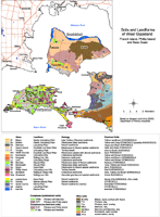 French Island, Phillip & Bass Coast | A PDF map is provided here that is suitable for printing at A3 or A4 scale. Note that this is not a clickable map when opened. To view the information PDF requires the use of a PDF reader. This can be installed for free from the Adobe website (external link).  French Island, Phillip Island & Bass Coast |