Victorian Resources Online (archived)
GP20
|
Location: Cranbourne | Aust. Soil Class: Parapanic, Humic, Semiaquic PODOSOL (very thick, sandy) |
| Northcote Factual Key: Uc 2.33 | Great Soil Group: podzol |
| General Site Description: Uncultivated grassed verge near edge of vegetable cropping paddock. | |
| Geology: Quaternary wind-blown sand. | Landscape Description: Sand dune on a gently undulating sand plain. |
| Soil Mapping Unit: Cranbourne sand. | |
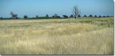
Soil Pit GP20 Landscape
Soil Profile Morphology:
Surface soil
| A1 | 0-15 cm | Black (10YR2/1); loamy sand; very weak consistence dry; pH 5.4; clear change to: | 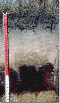 Soil Pit GP20 Profile |
| A21 | 15-40 cm | Greyish brown (10YR5/2) conspicuously bleached (10YR7/1d); sand; loose consistence dry; pH 5.0; clear change to: | |
| A22 | 40-80 cm | Very pale brown (10YR7/3) conspicuously bleached (10YR7/1d); sand; loose consistence dry; pH 5.3; sharp and tongued change to: | |
| Subsoil | |||
| Bhs | 80-125 cm | Very dark brown (10YR2/2) variably cemented sand (‘coffee rock'); some development of pipiness; strong consistence dry; pH 5.2; abrupt change to: | |
| C | 125-127 cm | Light grey (10YR7/2); sand; abrupt change to: | |
| D | 127 cm + | Grey (10YR6/1) with yellowish brown (10YR5/6) mottles; fine sandy loam; weakly structured; pH 5.5. | |
Key Profile Features:
- High sand content in deep surface (A) horizons.
- Presence of subsoil accumulation of organic matter and iron compounds (ie. ‘coffee rock’).
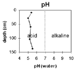 The soil profile is strongly acid throughout. | 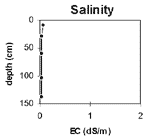 The salinity rating is very low throughout the soil profile. |
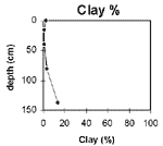
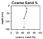 The clay percentage is low throughout the soil profile. | 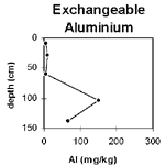 The coarse sand content is high throughout most of the soil profile. |
 Exchangeable aluminium levels are very low for the surface horizons. Levels increase in the 'coffee rock' zone. |
Horizon | Horizon Depth | pH water | pH CaCl2 | EC 1:5 | NaCI % | Exchangeable Cations | ExAl mg/kg | Ex Ac meg/100g | Field pF 2.5 | Wilting Point pF 4.2 | Coarse Sand (0.02 -0.2mm) | Fine Sand (0.02-0.2mm) | Silt (0.02-0.2mm) | Clay (<0.002mm) | |||
ca | mg | k | Na | ||||||||||||||
meg/100g | |||||||||||||||||
A1 | 0-15 | 5.4 | 4.4 | 0.07 | 3.4 | 0.08 | 0.29 | 0.18 | <10 | 9.5 | 5.9 | 48 | 41.5 | 2.5 | 2 | ||
A21 | 15-40 | 5 | 3.8 | <0.05 | 0.13 | 0.07 | 0.06 | <0.05 | 10 | 3.7 | 0.8 | 53.9 | 40.3 | 1 | 0.5 | ||
A22 | 40-80 | 5.3 | 4.1 | <0.05 | 0.5 | <0.05 | <0.05 | <0.05 | <10 | 3 | 0.5 | 52.3 | 44.3 | 1 | 0.5 | ||
Bhs | 80-125 | 5.2 | 4.3 | <0.05 | 0.14 | 0.18 | 0.13 | 0.08 | 150 | 6.9 | 3.2 | 44.5 | 44.7 | 1.5 | 3.5 | ||
D | 127+ | 5.5 | 4.2 | <0.05 | 0.15 | 1.4 | 0.11 | 0.31 | 66 | 14.2 | 5.1 | 16 | 56.4 | 1.6 | 13 | ||
Management Considerations:
Note: This pit site is on a grassed verge on the edge of a cropped paddock, and has never been cropped. Consequently, it will more closely represent uncropped conditions.
Whole Profile
- Plant available water capacity (PAWC) is considered to be very low (estimated at 42 mm). This is based on available laboratory data and assumes an effective rooting depth of 40 cm. Rooting depth will be restricted by the ‘coffee rock’ layer but is considered to be shallower as the strongly leached A2 horizon is very infertile and does not provide favourable conditions for plant growth. Most of this available water (ie. 24 mm) is likely to be held in the upper 15 cm of the soil profile.
- A major advantage of these soils is that they usually drain very well and can be worked throughout the year.
- The sandy surface horizons are very well drained and have a low water storage capacity. The low wilting point value (ie. 4 %) indicates that plants will be able to utilise light rains falling on dry soil. However, due to the low water storage capacity, plants will soon suffer moisture stress unless further rainfall occurs. Organic matter is important in these sandy soils to enhance water holding capacity.
- The sandy surface soil will be prone to wind erosion if plant cover is removed and blow-outs can occur.
- The surface soil has a very low inherent fertility (based on the sum of the exchangeable cations). Such strongly leached soils are also likely to be naturally deficient in nitrogen, phosphorus, sulphur and potassium. Regular fertiliser inputs are required for intensive cropping. Nitrate and sulphate are readily soluble and easily removed by leaching. More regular but smaller applications of fertiliser will assist in reducing loss of nutrients through leaching. Nutrients lost through leaching may influence catchment water quality.
- The sub-surface (A2) horizon is extremely infertile, so building up the surface (A1) soil should be a prime objective.
- Lime application will result in increased pH levels and make certain nutrients such as phosphorus more available to plants. Many vegetables prefer a pH closer to 6.5. Burnt lime is preferred when planting Brassica species or when a rapid pH change is required (pers. comm. Geoff Morrow).
- Deficiencies of the trace element molybdenum (Mo) are likely to occur in acid sandy soils (soil adsorption of Mo increases as pH decreases, leading to reduced availability to plants). U.S.A research has found that the following vegetables can be susceptible to molybdenum deficiency: Brassica species (eg. cauliflower, broccoli and cabbage), lettuce and tomato (Clark 1984). Any deficiencies can be confirmed by plant tissue analysis. Deficiencies can be remedied with molybdenum enriched fertiliser and foliar application. Lime application on acid soils will also make molybdenum more available to plants.
- Nutrients such as calcium and magnesium are usually low in strongly acid soils. Magnesium deficiency has been found to affect vegetables such as tomatoes, potatoes and cauliflowers (NSW Dept. Agric. 1987). Magnesium deficiency can be assessed by plant tissue analysis and can be treated by applying dolomite to the soil or using a foliar spray. Calcium deficiency can affect vegetable crops such as tomatoes, lettuce, celery, brussels sprouts and potatoes (NSW Dept. Agric. 1987). Foliar spray application, adjusting soil pH with lime application or using calcium based fertilisers can be utilised to treat deficiencies.
- The trace element boron (B) leaches rapidly through acid sandy soils and deficiencies are likely to occur. Susceptible crops include cauliflower, cabbage and celery (NSW Dept. Agric. 1986). Over-liming in sandy soils can make trace elements such as boron, zinc and manganese less available. Organic matter can complex with metal ions enabling trace elements (Fe, Zn, Cu) to become more available to plants.
- Organic matter is an important source of nutrient holding capacity in sandy soils. Levels of organic matter are often low in continually cropped vegetable growing soils and inputs such as poultry manure are often recommended.
Subsoil (B) Horizons
- The ‘coffee rock’ layer may restrict the downward movement of plant roots and water. In some situations, the temporary build up of water on top of this less permeable layer may be beneficial for deeper rooted plants in that it prevents deep drainage of water away from plant roots.
- Lime used to raise pH to 6.5.
- Fertilisers low in P and high in potash used.