Victorian Resources Online (archived)
GP25
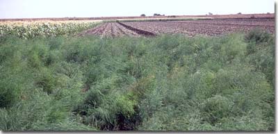
Location: Dalmore
Australian Soil Classification: Haplic, Self-mulching, Black VERTOSOL
Northcote Factual Key: Ug 5.1
Great Soil Group: black earth
Map Unit: Dalmore clay.
Landscape Description: Level plain.
General Site Description: Edge of asparagus crop.
Geology: Recent swamp deposits. Quartz and feldspar gravel in the deeper subsoil is likely to have originated from the Baw Baw area.
 GP25 Landscape |
Soil Profile Morphology:
Surface Soil:
| A1 | 0-10 cm | Black (10YR2/1); medium clay; self-mulching surface condition; strong consistence dry; pH 5.9; clear change to: | 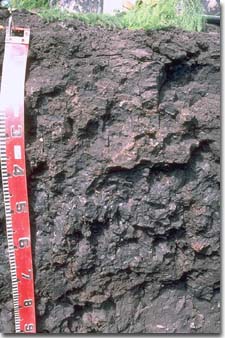 GP25 Profile |
| Subsoil: | |||
| B21 | 10-40 cm | Black (10YR2/1); medium heavy clay; weak blocky structure; some iron oxide coatings occur on ped faces; strong consistence dry; contains a few (2-5 %) quartz gravels (2-4 mm size); pH 5.9; clear change to: | |
| B22 | 40-70 cm | Black (10YR2/0); medium heavy clay; strong coarse polyhedral structure; shiny faced peds; some slickensides present; very firm consistence moist; contains some iron oxide staining in deeper root channels; pH 5.3; abrupt and wavy change to: | |
| B23 | 70-80 cm | Black (10YR2/0); peaty light clay; pH 5.6; abrupt change to: | |
| B24 | 80-100 cm | Very dark grey (10YR3/1) with slight yellowish brown (10YR5/8) mottles; light medium clay; contains a few (2-5 %) quartz and feldspar gravels (2-5 mm size); pH 5.8. |
- High clay content throughout profile.
- Vertic properties (ie. significant shrink-swell characteristic).
- Presence of peaty clay zone (humose horizon) in subsoil.
- Self-mulching surface soil.
Soil Profile Characteristics:
pH | Salinity Rating | Sodicity | Dispersion | |
Surface (A1 horizon) | Moderately Acid | Low | Non-Sodic | None1 |
Subsoil (B21 horizon) | Moderately Acid | Very Low | Non-Sodic | None2 |
Deeper subsoil (at 80-100 cm) | Moderately Acid | Very Low | Non-Sodic | None |
| 1 Moderate dispersion after remoulding. 2 Slight dispersion after remoulding. | ||||
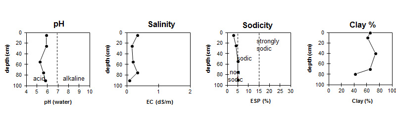
| The soil is moderately acid throughout most of the profile. |
|
| Clay content is high throughout the profile. |
Horizon | Horizon Depth (cm) | pH (water) | pH (CaCl2) | EC ds/m | Organic Carbon % | Nitrogen % | Exchangeable Cations | Exchangeable Aluminium mg/kg | Sodium Chloride % | Field Capacity pF 2.5 | Wilting Point pF 4.2 | Coarse Sand (0.02 -0.2mm) | Fine Sand (0.02 -0.2mm) | Silt (0.02 -0.2mm) | Clay (<0.002mm) | |||
Ca | Mg | K | Na | |||||||||||||||
meg/100g | ||||||||||||||||||
A1 | 0-10 | 5.9 | 5.5 | 0.33 | 5.1 | 0.28 | 20 | 6.7 | 2.2 | 0.73 | <0.05 | 44.7 | 26.2 | 5.7 | 5.2 | 10 | 65.5 | |
B21 | 10-40 | 5.9 | 5.2 | 0.16 | 14 | 7.7 | 1.9 | 0.94 | 43.1 | 26.2 | 9.9 | 4 | 9 | 61.5 | ||||
B22 | 40-70 | 5.3 | 4.7 | 0.2 | 12 | 12 | 1.3 | 1.1 | 34 | 51.3 | 31.6 | 3.6 | 2.5 | 6.5 | 74 | |||
B23 | 70-80 | 5.6 | 5.1 | 0.34 | 9.1 | 0.52 | 15 | 19 | 0.79 | 1.5 | <0.05 | 59 | 37.6 | 2.2 | 4.3 | 8 | 65 | |
B24 | 80-100+ | 5.8 | 4.9 | 0.09 | 4.5 | 8.1 | 0.31 | 0.6 | 32.3 | 17.4 | 11.2 | 25.1 | 20 | 42 | ||||
Management Considerations:
Note: This pit site occurs on the edge of an asparagus crop. It may not be representative of the whole cropped paddock.
- Whole Profile
- Plant available water capacity (PAWC) is considered to be medium-high (estimated at 150 mm) for the top metre of the soil profile. Effective rooting depth may vary depending on crop type. The PAWC should be considered a potential value only as rooting depth is likely to vary depending on soil structural degradation (eg. compaction) and variations in water table depths.
- Surface (A) Horizons
- The surface soil is self-mulching which will result in a seed-bed that is friable and easily worked.
- The high wilting point value (ie. 26 %) indicates that plants will be unable to fully utilise light rains falling on dry soil.
- The surface pH measured at the pit site is moderately acid and close to the preferred range for a number of vegetables. For a more representative pH value, samples should be collected from across the paddock and bulked together for analysis.
- The surface soil at this site has a relatively high inherent fertility (based on the sum of the exchangeable basic cations). Levels of exchangeable potassium, calcium and organic carbon are relatively high, and remain relatively high in the upper subsoil. The level of total nitrogen measured at this pit site is, however, relatively low in comparison to organic carbon levels. This measurement may not be representative of the cropped paddock, so samples should also be collected from across the paddock and bulked for analysis.
- Tillage of cracking clay soils should be avoided if the soil is wet (ie. wetter than the plastic limit). At such moisture conditions, excessive tillage, trafficking or overstocking can result in structural damage (eg. compaction, smearing) occurring. Ideally, tillage and trafficking should take place on clay soils when the soil is drier than the plastic limit, down to at least the depth of tillage.
- Subsoil (B) Horizons
- A soil pit or spade hole provides an opportunity to examine the soil below the surface and look for signs of structural degradation, which may have developed due to excessive compaction. Signs of degradation to look out for include: lack of natural shiny peds; development of coarse cloddy structure with 'flinty' appearance; presence of platy type soil fragments and distorted root growth. Evidence of degradation is usually evident in the 10 - 30 cm zone for Vertosols.
- The pH at the top of the subsoil is also moderately acid which is near the lower end of the preferred range for a number of vegetables.
- The subsoil displays vertic properties (ie. slickensides, lenticular peds) and will therefore experience significant shrinking and swelling with wetting and drying cycles. This may disturb the roots of some plant species and has engineering implications (eg. disturbance to building foundations and fence lines).
Landholders Comments:
- This area has been under continuous cultivation for about 75 years.
- Disc plough used to turn over soil to a depth of 50 cm.
- Four wheel drive machinery needed to get on land in wet conditions.
Profile Described By: Mark Imhof and Ian Sargeant (March 1996)