Victorian Resources Online (archived)
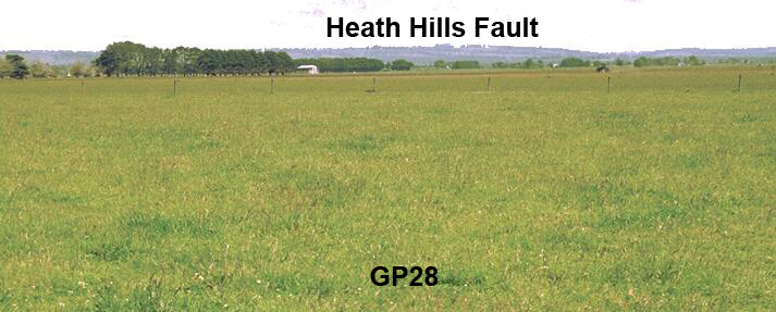
GP28
Location: Catani
Australian Soil Classification: Humose-Acidic (and Vertic), Eutrophic, Grey DERMOSOL
Northcote Factual Key: Gn 3.90
Great Soil Group: humic gley
Map Unit: Koo-Wee-Rup peaty clay
Landscape Description: Lacustrine plain
General Site Description: Pasture paddock
Geology: Recent swamp deposits
 GP28 Landscape GP28 Landscape |
Surface soil:
| A1 | 0-20 cm | Very dark greyish brown (10YR3/2); light clay (organic); moderate coarse blocky, parting to weak fine polyhedral structure; firm consistence moist; pH 4.8; sharp change to: | 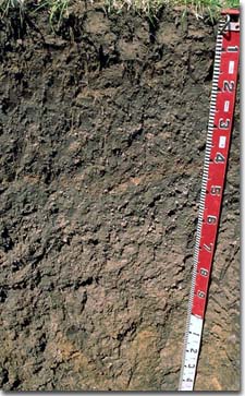 GP28 Profile |
| Subsoil: | |||
| B21 | 20-40 cm | Dark greyish brown (10YR4/2) with root channel staining; light medium clay (gritty); weak coarse blocky structure; contains quartz fragments; has a brown ash zone (1-2 cm thick); pH 4.9: | |
| B22 | 40-75 cm | Grey (10YR5/1); medium heavy clay (gritty); contains few (10%) quartz fragments (2-4 mm in size); pH 5.2: | |
| B23 | 75-100 cm | Dark grey (10YR4/1) with strong brown (7.5YR5/8) mottles (associated with root channels); heavy clay (gritty); parts to strong fine lenticular structure; feldspar and quartz fragments are common (15-20%) ; pH 5.1: | |
| B24 | 100+ cm | Grey (10YR5/1) with yellowish brown (10YR5/8) mottles; medium clay; strong medium lenticular, parting to to strong fine lenticular structure; contains very little (< 2%) quartz grit; pH 4.9. | |
- Organic rich surface soil (ie. humose horizon).
- Lack of strong texture contrast between surface soil and subsoil horizons.
- Vertic properties (ie. lenticular structure) evident in deeper subsoil.
Soil Profile Characteristics:
pH | Salinity Rating | Sodicity | Dispersion | |
Surface (A1 horizon) | Very Strongly Acid | Low | Non-Sodic | None |
Subsoil (B21 horizon) | Very Strongly acid | Very Low | Non-Sodic | None1 |
Deeper Subsoil (at 75-100 cm) | Strongly Acid | Low | Non-Sodic | None |
| 1 40-70cm depth – Moderate dispersion after remoulding. | ||||
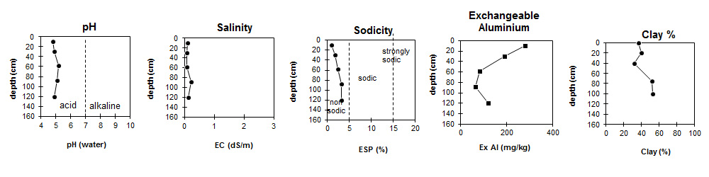
| The upper soil profile is very strongly acid becoming strongly acid at depth. | The salinity rating is low throughout. | The soil profile is non-sodic throughout. | Exchangeable aluminium levels are high in the upper soil profile and decrease with depth. | Clay content is high throughout the profile. |
Horizon | Horizon Depth (cm) | pH (water) | pH (CaCl2) | EC ds/m | Organic Carbon % | Nitrogen % | Exchangeable Cations | Exchangeable Aluminium mg/kg | Exchangeable Acidity meg/100g | Field Capacity pF 2.5 | Wilting Point pF 4.2 | Coarse Sand (0.02 -0.2mm) | Fine Sand (0.02 -0.2mm) | Silt (0.02 -0.2mm) | Clay (<0.002mm) | |||
Ca | Mg | K | Na | |||||||||||||||
meg/100g | ||||||||||||||||||
A1 | 0-20 | 4.8 | 4.1 | 0.1 | 7.4 | 0.59 | 2.7 | 1.1 | 0.57 | 0.34 | 280 | 33.0 | 42.2 | 19.5 | 21 | 11 | 15 | 37 |
B21 | 20-40 | 4.9 | 4.2 | 0.08 | 2.1 | 0.12 | 2.8 | 1.8 | 0.24 | 0.33 | 190 | 14.0 | 30.2 | 15.3 | 29 | 12 | 13 | 40 |
B22 | 40-75 | 5.2 | 4.4 | 0.08 | 1.1 | 0.05 | 2.8 | 2.3 | 0.24 | 0.33 | 82 | 8.1 | 21.7 | 11.5 | 35 | 15 | 14 | 32 |
B23 | 75-100 | 5.1 | 4.6 | 0.21 | 4.2 | 4.5 | 0.36 | 0.51 | 63 | 6.1 | 31.2 | 17.2 | 27 | 10 | 9 | 52 | ||
B24 | 100+ | 4.9 | 4.2 | 0.12 | 2.8 | 4.6 | 0.32 | 0.45 | 120 | 5.9 | 31.7 | 18 | 25 | 10 | 10 | 53 | ||
Management Considerations:
- Whole Profile
- Plant available water capacity (PAWC) is considered to be low-medium (estimated at 97 mm) for the top metre of this soil profile. This is based on available laboratory data. Effective rooting depth is likely to vary, however, depending on crop type. PAWC should therefore be considered as potential only. Factors which may decrease effective rooting depth and PAWC include: structural degradation due to compaction, variations in water table depth and high exchangeable aluminium levels.
- The profile is very strongly acid throughout. Some vegetables will not grow well in these highly acid conditions. Many vegetables have a preferred pH range beginning above 5.5, although potatoes have a preferred range of between 5.0 - 6.0. Acid soils can also have high aluminium and manganese levels, which may be toxic to some plants.
- Surface (A) Horizons
- The levels of organic carbon levels and total nitrogen measured at this pit site are high. These measurements are best assessed though by taking a bulked sample from across the paddock. Organic matter levels will build up under pasture but will decline if cropping takes place. Practices such as residue retention, minimum tillage and including pasture rotations could be utilised if cropping takes place in order to retain organic matter. The use of green manure crops (eg. oats, ryecorn, lupins) will also assist in building up organic matter levels between crops. Organic matter is important for maintaining soil aggregation as well as fertility and water holding capacity. PAWC is relatively high for the surface horizon (estimated at 32 mm).
- Molybdenum deficiency may occur in the strongly acid surface soil. Lime application will make molybdenum more available to plants. However, if a deficiency occurs it may be more practical to apply a molybdenum compound to the soil or crop.
- Aluminium becomes more soluble in soils at low pH levels. The level of exchangeable aluminium measured in the laboratory is very high (ie. 280 ug/g) for the surface soil at this site. This is likely to restrict the growth of aluminium sensitive plant species (eg. lucerne, phalaris). High levels of aluminium will also tend to 'fix' phosphorus and make it less available to plants (and reduce the effectiveness of applied P fertiliser). Raising the pH level of the soil by liming will help reduce the level of exchangeable aluminium. A lime test (sampled across the paddock) may be appropriate to determine the amount of lime needed to raise pH levels. Other factors need to be considered, however, before lime is recommended (eg. species grown, method of application, local trial responses, likely cost-benefit). The relatively high levels of organic matter in these soils may assist in reducing the effects of aluminium on plants. Organic materials have been known to be effective in reducing the level of active aluminium in soils (Vimpany 1990).
- Manganese toxicity can also occur in strongly acid soils, especially when waterlogging occurs. Susceptible crops include cabbage, cauliflower, lettuce, celery and lucerne (NSW Dept. Agric. 1986). Raising the pH by lime application will assist in reducing any manganese toxicity.
- Subsoil (B) Horizons
- The level of exchangeable aluminium is still high in the upper subsoil but decreases with depth. Lime application at the soil surface will not have a significant effect on pH and aluminium levels in the subsoil.
- The deep subsoil is strongly mottled which indicates that deep drainage is imperfect.
- The deeper subsoil (from 75 cm depth) displays vertic properties (ie. lenticular structure) which indicates that significant shrinking and swelling occurs during wetting and drying cycles. This may disturb the roots of some plant species. The shrinking and swelling also has engineering implications (eg. disturbance to building foundations and fence lines).
Profile Described By: Mark Imhof and Ian Sargeant (December 1996).